
Franklin County is a county on the northern border of the U.S. state of New York. To the north across the Canada–United States border are the Canadian provinces of Quebec and Ontario, from east to west. As of the 2020 census, the county population was 47,555. Its county seat is Malone. The county is named in honor of United States Founding Father Benjamin Franklin. The county is part of the North Country region of the state.

St. Regis or Saint Regis is an unincorporated community and census-designated place (CDP) in Mineral County, Montana. The population was 313 at the time of the 2020 census.
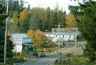
Waverly is a town in Franklin County, New York, United States. The population was 1,022 at the 2010 census. The town is on the western border of the county, southwest of Malone.

Brasher is a town in St. Lawrence County, New York, United States. The population was 2,512 at the 2010 census. The town is named after Philip Brasher, an original landowner.

Hopkinton is a town in St. Lawrence County, New York, United States. The population was 1,105 at the 2020 census and has a Population density of 5.9 square miles. The town is named for Roswell Hopkins, a pioneer settler and a government official.

Great Falls is a census-designated place in Fairfax County, Virginia, United States. The population at the 2020 census was 15,953.

Paul Smiths is a hamlet and census-designated place (CDP) in the town of Brighton in Franklin County, New York, United States. It is located on Lower Saint Regis Lake in the Adirondacks, 12 miles (19 km) northwest of Saranac Lake, located at 44°26' North 74°15' West. The population of the CDP was 671 at the 2010 census.

Darlington is an unincorporated community and census-designated place in northeastern Harford County, Maryland, United States. The population was 409 at the 2010 census. The center of the community was listed on the National Register of Historic Places as the Darlington Historic District in 1987. Median household income is $66,563. The percentage of people in poverty is 5.3%.
Stone Ridge is a census-designated place in Loudoun County, Virginia, United States. Residences use Aldie mailing addresses, and it is near Washington Dulles International Airport. The population as of the 2020 census was 15,039. Stone Ridge is a Van Metre Homes planned, mixed-use community.

New York State Route 458 (NY 458) is a state highway in the North Country of New York in the United States. It extends for 24.42 miles (39.30 km) from an intersection with NY 11B in the St. Lawrence County town of Hopkinton to a junction with NY 30 in the Franklin County town of Brighton. The route follows a generally northwest–southeast alignment between the two points, serving only small hamlets as it crosses an otherwise rural area of the North Country. NY 458 was assigned on July 1, 1972 to the former routing of NY 72 east of the Hopkinton hamlet of Nicholville. Prior to being signed as part of NY 72 in 1930, it was designated as part of NY 56 in the 1920s.
Brasher Falls is the largest hamlet and a census-designated place (CDP) in the town of Brasher in St. Lawrence County, New York, United States. As of the 2010 census, it had a population of 669.
Winthrop is a hamlet and census-designated place (CDP) in the town of Stockholm in St. Lawrence County, New York, United States. As of the 2010 census, it had a population of 510.
Highgate Center is the primary village and a census-designated place (CDP) in the town of Highgate, Franklin County, Vermont, United States. As of the 2020 census it had a population of 361, out of 3,472 in the entire town of Highgate.

Robertsville is a census-designated place and unincorporated community in Marlboro Township, Monmouth County, in the U.S. state of New Jersey. As of the 2020 census, the CDP's population was 11,399.

Hyde Park is a hamlet and census-designated place (CDP) in the town of Hyde Park, Dutchess County, New York, United States. Its population was 1,908 as of the 2010 census.
Fort Covington is a census-designated place (CDP) within the town of Fort Covington, Franklin County, New York, United States. It consists of the hamlet of Fort Covington, as well as a large amount of rural land surrounding the hamlet, such that the CDP occupies about one half of the area within the town limits. The population of the CDP was 1,308 at the 2010 census, out of a total town population of 1,676.
Colton is the primary hamlet and a census-designated place (CDP) in the town of Colton in St. Lawrence County, New York, United States. As of the 2010 census, it had a population of 345, out of 1,451 in the entire town of Colton.
Madrid is the primary hamlet and a census-designated place (CDP) in the town of Madrid in St. Lawrence County, New York, United States. At the 2020 census, it had a population of 736, out of 1,735 in the entire town of Madrid.
Parishville is the primary hamlet and a census-designated place (CDP) in the town of Parishville in St. Lawrence County, New York, United States. As of the 2010 census, it had a population of 647, out of 2,153 in the entire town of Parishville.
Kysorville is a hamlet and census-designated place (CDP) in the town of West Sparta, Livingston County, New York, United States. Its population was 110 as of the 2010 census.


