
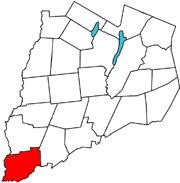
Plainfield is a town in Otsego County, New York, United States. The population was 915 at the 2010 census.
Unadilla is a town in Otsego County, New York, United States. As of the 2010 census, the town had a population of 4,392. The name is derived from an Iroquois word for "meeting place". Unadilla is located in the southwest corner of the county, southwest of Oneonta. The Village of Unadilla is located in the southern part of the town. The mayor of Unadilla is David Welch, as of January 13, 2020.

The Unadilla River is a 71-mile-long (114 km) river in the Central New York Region of New York State. The river begins northeast of the hamlet of Millers Mills and flows generally south to the village of Sidney, where it converges with the Susquehanna River, which drains into the Chesapeake Bay, a bay of the Atlantic Ocean.

The Churchill Mountains are a mountain range group of the Transantarctic Mountains System, located in the Ross Dependency region of Antarctica. They border on the western side of the Ross Ice Shelf, between Byrd Glacier and Nimrod Glacier.

Leonardsville is a hamlet on the Unadilla River in the Town of Brookfield in Madison County, New York, United States. A portion of it does also extend into the Town of Plainfield in Otsego County, New York, United States.
Unadilla Forks is a hamlet in the Town of Plainfield in Otsego County, New York, United States, at the confluence of the two branches of the Unadilla River on the Otsego-Madison County border.

The Line of Property is the name commonly given to the line dividing Indian from British Colonial lands established in the 1768 Treaty of Fort Stanwix between the British officials and the Indian tribes. In western Pennsylvania it is referred to as the Purchase line.
County Route 18 (CR 18) is a county-maintained highway in western Otsego County, New York, in the United States. It extends for 34.83 miles (56.05 km) from an intersection with New York State Route 51 (NY 51) in the town of Butternuts to the Oneida County line at Plainfield, where it becomes CR 2. The highway runs along the eastern bank of the Unadilla River and parallels NY 8, which follows the western bank of the river. CR 18 enters the vicinity of several villages and hamlets, including the village of New Berlin and the hamlet of Unadilla Forks.

Unadilla Forks School, also known as Plainfield Town District No. 8 School and Wimac Rebekan Lodge 51, is a historic school building located at Unadilla Forks in Otsego County, New York. It was built in 1902 and is a two-story rectangular structure, with a two-story central projecting vestibule wing. The building is of balloon frame construction with clapboard siding. The school closed in 1931 and in 1940 it was purchased by the Independent Order of Odd Fellows.
The West Branch Unadilla River flows into the Unadilla River near Unadilla Forks, New York. This branch was known as Eghwagy Creek during the early 18th century.
Butternut Creek flows for 37 miles before converging with the Unadilla River just downstream of Mount Upton, New York. The creek has many fish for fishing dominated by largemouth bass, smallmouth bass, wall-eye, chain pickerel, rock bass, and yellow perch.
The Center Brook converges with the Unadilla River in New Berlin, New York. The Center Brook has one main tributary, the Shawler Brook which converges with Center Brook in New Berlin, New York. The Center Brook is part of the Unadilla River watershed.
Moyer Creek starts at Wheelock Pond near Jerusalem Hill, New York. Past Gulph, New York Moyer Creek follows a deep ravine, the Frankfort Gorge, south towards Frankfort, New York before converging with the Mohawk River in Frankfort, New York. The headwaters of Moyer Creek rise within a half mile of the source of the Unadilla River which is the most northerly headwater source of the Susquehanna and the closest to the Mohawk River.

Mount Wellington is a mountain located in the Central New York Region of New York. It is located south of the Hamlet of Springfield Center at the northern end of Otsego Lake. Mount Wellington rises 600 feet (180 m) above lake level. The extreme southern point of the mountain is called Clarke Point and also referred to as the Shad Cam. It is known as "The Sleeping Lion", as it looks similar to a lion laying down, viewed from Cooperstown, New York. It was originally named Mount Millington, but was renamed by George Hyde Clarke in honor of Field Marshal The 1st Duke of Wellington, the victor of Waterloo, who had been Clarke's schoolmate at Eton College in England.
Sisson Hill is a mountain in the Central New York region of New York. It is located northwest of Unadilla, New York.
Mount Moses is a mountain in the Central New York region of New York. It is located west of Riverside and north of Sidney. The Unadilla River converges with the Susquehanna River southwest of Mount Moses. Hutchinson Hill is located north-northeast.
Kilkenny Hill is a mountain in the Central New York region of New York, USA. It is located northwest of Unadilla, New York. Kilkenny Hill is part of the Northern Allegheny Plateau Ecoregion.
Mount Zion is a small mountain chain in the Central New York region of New York. It is located southwest of Otego, New York. It is made of two main peaks. One is in Otsego County and the other, being the tallest at 1988 feet, in Delaware County.
Mount Tom is a mountain in the Central New York region of New York. It is located north of Springfield Four Corners, New York.
Campbell Brook is a river in Otsego County, New York. It flows into Unadilla River south of Unadilla Forks and southwest of Mount Markham.

