Snowy Mountain (New York)

Last updated
Snowy Mountain
Snowy Mountain from NY 30.jpg
Snowy Mountain as viewed from the north on NY Route 30
Highest point
Elevation 3,899 ft (1,188 m)  NGVD 29 [1]
Prominence 2,225 ft (678 m) [1]
Listing
Coordinates 43°42′01″N74°23′10″W / 43.7003432°N 74.3859856°W / 43.7003432; -74.3859856 Coordinates: 43°42′01″N74°23′10″W / 43.7003432°N 74.3859856°W / 43.7003432; -74.3859856 [2]
Geography
New York Adirondack.svg
Red triangle with thick white border.svg
Snowy Mountain
Location of Snowy Mountain within New York
Usa edcp relief location map.png
Red triangle with thick white border.svg
Snowy Mountain
Snowy Mountain (the United States)
Location Hamilton County, New York
Parent range Adirondack Mountains
Topo map USGS Snowy Mountain

Snowy Mountain is a mountain located in Hamilton County, New York. Initially known as 'Squaw Bonnet', its summit is the highest point in the county. While most maps show the elevation as 3899 feet, some suggest that more recent surveys have it as 3904 feet or even 3908 feet.

Contents

Description

The mountain is the highest in the Adirondack Mountains south of the 4,000 ft (1,200 m) High Peaks region. It is one of thirteen mountains in New York with more than 2,000 ft (610 m) of topographic prominence. Snowy Mountain is flanked to the northeast by Beaver Mountain (3239 feet), and to the southwest by Lewey Mountain (3742 feet). A subsidiary ridge comes off the summit to the east ending at unnamed 'Peak 3149' (3149 feet) which forms the head of a large bowl overlooking the Griffin Brook drainage.

Snowy Mountain stands within the watershed of the Hudson River, which drains into New York Bay. The south end of the northwest side of Snowy Mountain drains into Little Squaw Brook, thence into the Cedar River, and the Hudson River. The north side of Snowy Mountain drains into Squaw Brook, thence into Indian Lake, Lake Abanakee, the Indian River, and the Hudson River. The northeast end of Snowy Mountain drains into Beaver Brook, thence into Indian Lake. The southeast slopes of Snowy Mountain drain into Indian Lake via Griffin Brook, Forks Brook, Willow Brook, and Falls Brook.

It is the location of the recently restored Snowy Mountain Fire Observation Station, i.e. 'fire tower', listed on the National Register of Historic Places in 2001. [3] In 1909, after the disastrous forest fires of 1903 and 1908, New York State began erecting observation towers on strategically located peaks, such as Snowy Mountain, as part of a comprehensive forest fire suppression program for the Adirondack Mountains. That year a fifteen foot high log tower and a small log cabin were erected on the summit of Snowy Mountain. A telephone line was strung from the tower to Indian Lake village, a distance of 11 1/2 miles. Upon sighting smoke, the observer would call in the location of a suspected forest fire. With reports from observers on other nearby mountains, the exact location of the fire could be calculated by triangulation and fire suppression crews dispatched most expeditiously. In 1917, a steel tower 22 feet high replaced the log tower. In 1933, the steel tower was raised 33 feet so observers could see over the surrounding trees (one must assume that Verplanck Colvin and his men cleared the summit of most, if not all, trees in 1872 for triangulation sightings to distant peaks during the Adirondack Survey). In 1971, the Snowy Mountain fire tower was closed when NYS decided that it was unnecessary for protecting the Adirondack Park from forest fires (airplanes could do the job equally well). [4] Several years later (it was there in 1986, but gone in 2006), the observer's cabin was removed.

Due to its high elevation and the restored fire tower, Snowy Mountain is a popular hiking destination. While the trip is nearly an eight-mile walk involving more than 2000 feet of elevation gain, many find its views well worth the effort.

While the history of ascending this peak is surely incomplete, this much is known: The earliest known ascent is said to have been in 1771 by Archibald Campbell, a surveyor from Albany, NY. In that year, Joseph Totten and Stephen Crossfield were negotiating the purchase of a huge land tract from the Mohawk Nation (Six Nation Confederacy) for Edward and Ebenezer Jessup who had great influence with Sir William Johnson, NY Governor Dunmore and General Tryon. One can imagine that Campbell was dispatched to the area to find out something about what was being purchased. Verplanck Colvin and his crew climbed it on 4 August 1872 for the Adirondack Survey. Mills Blake, Colvin's assistant, and his crew climbed it again ten years later on 7 November 1882 to complete some triangulations, again for the Adirondack Survey. One might wonder about their itinerary for they were again on the summit on 9 and 10 November. Due to the four mile approach, it seems likely that the survey crew bivouacked on the summit at least for the last two days. There is some speculation that Colvin may have been among the group on the 9th. While technically not 'winter', some consider this to be the earliest known 'winter' ascent. Colvin made his second (perhaps 3rd) ascent of this peak on 22 June 1885 when he certainly bivouacked on the summit. [5] [6]

View of Snowy Mountain from Pillsbury Mountain in May 2021 Snowy Mountain from Pillsbury Mountain May 2021.JPG
View of Snowy Mountain from Pillsbury Mountain in May 2021

It is not known when the hiking trail was built, but one can imagine that it may have existed before the fire tower in 1909.

Rockclimbing at Snowy Mountain: In the mid-1990s, the peak was visited by Neal Knitel and Jonas Morelli who attempted a route on the left side of the summit cliff. They never returned to complete their route because "it was too far and there was other stuff to do." In 2002, unbeknownst to each other, two parties began working climbing routes at Snowy Mountain: Karl Swisher and Sid Perkins, and Ed Palen and Bob Starinsky. By 2008, seven high quality routes had been put up. All are bolt-protected face climbing on highly featured rock.

Part-way up the Griffin Brook drainage toward Peak 3149, lie the Snowy Mountain Boulders, a unique collection of boulders featuring the largest collection of huecos in the Adirondack Park. This unique bouldering area was initially noticed by Dave Buzzelli in 2003 while on the approach to the slides on Peak 3149 for skiing. Over 40 bouldering problems have been put up here since 2006. [7]

See also

Related Research Articles

<span class="mw-page-title-main">Verplanck Colvin</span> American lawyer

Verplanck Colvin (1847–1920) was a lawyer, author, illustrator and topographical engineer whose understanding and appreciation for the environment of the Adirondack Mountains led to the creation of New York's Forest Preserve and the Adirondack Park.

Esther Mountain Mountain in New York, United States

Esther Mountain is a mountain located in Essex County, New York. The mountain is the northernmost of the High Peaks of the Adirondack Mountains and its 28th highest peak. It was the only High Peak named for a woman until 2014, having been named in honor of Esther McComb, who made the first recorded climb to the summit in 1839, at age 15; at the time she was attempting to climb Whiteface Mountain from the north.

Blake Peak is a mountain located in Essex County, New York. The mountain is named after Mills Blake, Verplanck Colvin’s chief assistant during the Adirondack Survey. It is part of the Colvin Range. Blake Peak is flanked to the northeast by Mount Colvin, and to the southwest by Pinnacle.

Dial Mountain Mountain in the United States

Dial Mountain is a mountain located in Essex County, New York. The mountain is part of the Colvin Range. Dial Mountain is flanked to the southwest by Nippletop.

Nippletop Mountain in New York, United States

Nippletop is a mountain located in Essex County, New York. The mountain is part of the Colvin Range. Nippletop is flanked to the northeast by Dial Mountain. To the east, it faces Dix Mountain across Hunters Pass, and to the west it faces Mount Colvin across Elk Pass.

Phelps Mountain (New York) Mountain in New York, United States

Phelps Mountain is a mountain located in Essex County, New York. The mountain is named after Orson Schofield "Old Mountain" Phelps (1817–1905), who cut the first trail up Mount Marcy and named several of the Adirondack peaks. It is the 32nd highest peak in New York. Phelps Mountain is flanked to the southeast by Table Top Mountain.

Allen Mountain (New York) Mountain in New York, United States

Allen Mountain is located in Essex County, New York. It is part of the Marcy Group of the Great Range of the Adirondack Mountains, and is flanked to the north by Mount Skylight.

Mount Redfield is a mountain located in Essex County, New York. The mountain is part of the Marcy Group of the Great Range of the Adirondack Mountains. Mount Redfield is flanked to the northwest by Cliff Mountain, and to the northeast by Mount Skylight.

Mount Emmons (New York) Mountain in New York, United States

Mount Emmons is a mountain located in the Adirondack Mountains near the southern edge of Franklin County, New York, United States.

Nye Mountain is a mountain located in Essex County, New York, named after William B. Nye (c.1815–1893), an Adirondack mountain guide. Nye Mountain is part of the Street Range of the Adirondack Mountains; it is flanked to the southwest by Street Mountain.

Lyon Mountain (Clinton County, New York) Mountain in United States of America

Lyon Mountain is a 3,820 ft (1,160 m) mountain located in Clinton County, New York, the county’s high point. It is named for Nathaniel Lyon, an early settler of the area who moved from Vermont in 1803 and died circa 1850. The mountain is within New York's Adirondack Park.

Black Mountain is a mountain located in Washington County, New York, of which its peak is the highest point. Isolated from the rest of the Adirondack Mountains by Lake George, Black Mtn. has the seventh highest topographic prominence of all the mountains in New York. Black Mountain also has the highest elevation of any of the peaks which surround Lake George and offers unobstructed views of the lake from its summit.

Balsam Mountain (Ulster County, New York) 28th highest peak of Catskill Mountains

Balsam Mountain is one of the High Peaks of the Catskill Mountains in the U.S. state of New York. Its exact height has not been determined, so the highest contour line, 3,600 feet (1,100 m), is usually given as its elevation. It is located in western Ulster County, on the divide between the Hudson and Delaware watersheds. The summit and western slopes of the peak are within the Town of Hardenburgh and its eastern slopes are in Shandaken. The small community of Oliverea is near its base on that side. Most of the mountain is publicly owned, managed by the New York State Department of Environmental Conservation as part of the state Forest Preserve, part of the Big Indian-Beaverkill Range Wilderness Area in the Catskill Park. The summit is on a small corner of private land.

Ampersand Mountain Mountain in New York state, United States

Ampersand Mountain is a 3,352 ft (1,021.7 m) mountain in Franklin County in the High Peaks Wilderness Area of the northeastern Adirondacks, west of the High Peaks proper in New York State. The trail up the mountain begins on New York State Route 3 8.1 miles (13.0 km) southwest of the village of Saranac Lake, near Middle Saranac Lake; it is a popular day hike. The mountain takes its name from nearby Ampersand Creek, so named because it twists and turns like the ampersand symbol. The summit is bare rock, with extensive views of the High Peaks to the east and the Saranac Lakes to the west. Stony Creek Mountain is located west-southwest of Ampersand Mountain. The mountain is notable as the land surrounding its hiking trail's initial ascent is generally acknowledged as unlogged old growth forest.

Hurricane Mountain Mountain in New York, United States

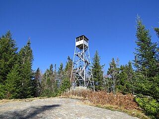
Hurricane Mountain is a 3,688-foot-tall (1,124 m) mountain near Keene in the north of the High Peaks region of the Adirondacks in New York, United States. It is considered to boast some of the most impressive views of any of the lesser peaks; this is due to its prominence, and because its summit was cleared by Verplanck Colvin in the course of his early survey of the Adirondacks. On a clear day, the length of Lake Champlain and the Green Mountains of Vermont are visible to the east, and many of the High Peaks can be seen to the south through the northwest. There is a disused fire tower on the top.

Saint Regis Mountain Mountain in New York State, U.S.

Saint Regis Mountain is a 2,838-foot-tall (865 m) mountain in the town of Santa Clara, New York, in Franklin County at the center of the Saint Regis Canoe Area in the Adirondack Park.

Poke-O-Moonshine Mountain, spelled Pokamoonshine on U.S. Geological Survey maps, and sometimes known as just Poke-O, is a minor peak of the Adirondack Mountains. The name is believed to be a corruption of the Algonquin words pohqui, meaning 'broken', and moosie, meaning 'smooth'. It is located in the town of Chesterfield, New York, United States, on New York state Forest Preserve land, part of the Taylor Pond Wild Forest complex within the Adirondack Park. Due to its location next to the pass through which most travelers from the north enter the range, it has been called the "gateway to the Adirondacks".

Bald Mountain (Herkimer County, New York) Part of the Adirondack Mountains in the U.S. state of New York

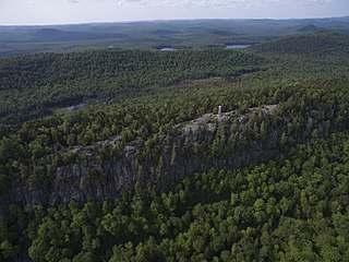
Bald Mountain, or Rondaxe Mountain, is a part of the Adirondack Mountains in the U.S. state of New York. The trail leading up the mountain is a popular hike, likely due to its proximity to tourist towns. The mountain is also home to the Rondaxe Mountain Fire Tower, which contributes to the trail's popularity.

Owls Head Mountain Mountain in New York, United States

Owls Head Mountain is a 2,786-foot-tall (849 m) mountain in the Adirondack Mountains region of New York. It is located west-southwest of the hamlet of Long Lake in Hamilton County.

<span class="mw-page-title-main">Mount Morris (New York)</span> Mountain in New York, United States

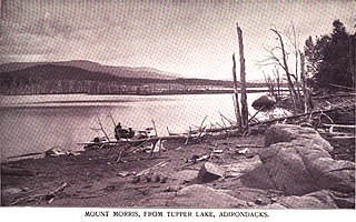
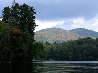
Mount Morris is a 3,117-foot-tall (950 m) mountain located in Adirondack Mountains of New York. It is located in the south-southwest of the village of Tupper Lake in Franklin County, and is "the highest peak immediately east of Tupper Lake." It is named after the town in which it was then located.

References

  1. 1 2 "Snowy Mountain, New York". Peakbagger.com. Retrieved 2010-04-16.
  2. "Snowy Mountain". Geographic Names Information System . United States Geological Survey, United States Department of the Interior . Retrieved 2010-04-17.
  3. "National Register Information System". National Register of Historic Places . National Park Service. March 13, 2009.
  4. Podskoch, Martin, 2003. Adirondack Fire Towers: Their History and Lore, The Southern Districts, Purple Mountain Press, Fleischmanns, NY, ISBN   978-0-9794979-2-6, pp. 179-184.
  5. Rosevear, Francis B., 1992. Colvin in the Adirondacks: A Chronology and Index, North Country Books, Utica, NY, pp. 4, 37, 47.
  6. Donaldson, Alfred L., 1992. A History of the Adirondacks, 2 volumes, Purple Mountain Press, Fleischmanns, NY (originally pub. in 1921 by The Century Co., NY), pp. 51-61
  7. Lawyer, Jim and Haas, Jeremy, 2008. Adirondack Rock: A Rock Climber's Guide, Adirondack Rock Press, LLC., Pompey, NY, ISBN   978-0-9814702-0-7, pp. 525-532.