
Arietta is a town in Hamilton County, New York, United States. The population was 304 at the 2010 census. The town was named after the mother of one of the first settlers, Rensselaer Van Rennslaer.

The Mendocino National Forest is located in the Coastal Mountain Range in northwestern California and comprises 913,306 acres (3,696 km2). It is the only national forest in the state of California without a major paved road entering it. There are a variety of recreational opportunities — camping, hiking, mountain biking, paragliding, backpacking, boating, fishing, hunting, nature study, photography, and off-highway vehicle travel.

Berlin Mountain is a 2,818-foot-tall (859 m) prominent peak in the Taconic Mountains of western New England and is located adjacent to Massachusetts's border with New York State. It is the highest point in Rensselaer County. The summit and west side of the mountain are located in New York; the east side lies within Williamstown, Massachusetts. The mountain is a bald, notable for its grassy summit and expansive views of the Hudson River Valley to the west. The 37-mile (60 km) Taconic Crest Trail traverses the mountain. Several other hiking trails approach the summit from the east. Much of the upper slopes and summit are within protected conservation land. Historically the lower slopes of the mountain were farmed heavily throughout the 19th Century. In addition to agriculture, there are several remnants of charcoal kilns located on the mountain that produced fuel for iron smelting.

Blue Mountain is a peak in the Adirondack Mountains of New York State in the United States. Located east of Blue Mountain Lake, Hamilton County, the peak reaches a height of 3750 ft/1143m. For hiking, the elevation gain is 1,559 feet and the trail length is four miles. The trailhead elevation is 2,200 feet. It is the location of the Blue Mountain Fire Observation Station, listed on the National Register of Historic Places in 2001.

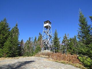
The Pillsbury Mountain Forest Fire Observation Station is a historic fire observation station located on Pillsbury Mountain summit at Arietta in Hamilton County, New York. The tower was built in 1924 by the Aermotor Windmill Company and the associated observer's cabin and shed in 1950. The lookout tower measures 69 feet tall.
Owls Head Mountain is a 2,786-foot-tall (849 m) mountain in the Adirondack Mountains region of New York. It is located west-southwest of the hamlet of Long Lake in Hamilton County.

Vanderwhacker Mountain is a 3,389-foot-tall (1,033 m) mountain in the Adirondack Mountains region of New York. It is located northeast of Indian Lake and southeast of Newcomb in Essex County. The Vanderwhacker Mountain Fire Observation Station is located on top of the mountain. In May 1911, the Conservation Commission built a wooden fire observation tower on the mountain which was replaced in 1918, with a 35-foot-tall (11 m) metal tower. The tower stopped fire watching operations at the end of the 1988 season.
Cedar Lake is located northwest of Sled Harbor, New York. Fish species present in the lake are brook trout, black bullhead, and white sucker. There is trail access on the north and west shores from Sled Harbor. There is also trail access to Whitney Lake. No motors are allowed on this lake.
Dairy Hill is a 1,844-foot-tall (562 m) summit located in Central New York Region of New York located in the Town of Norway in Herkimer County, southeast of Norway. The mountain is the former location of a 79-foot-6-inch-tall (24.23 m) steel fire lookout tower.

Dun Brook Mountain is a mountain located in Adirondack Mountains of New York located in the town of Indian Lake east-northeast of Blue Mountain Lake. Tirrell Mountain is located west and Tirrel Pond is located west-southwest of Dun Brook Mountain.
Meenahga Mountain is a 2,087-foot-tall (636 m) mountain located in Adirondack Mountains of New York. It is located in the northeast of the hamlet of Paul Smiths in Franklin County. The mountain is the site of a 73-foot-tall (22 m) Aermotor LS40 fire lookout tower.
Salmon Lake Mountain is a 2,500-foot-tall (760 m) summit located in Adirondack Mountains of New York. It is located west of the hamlet of Long Lake in Hamilton County. Around 1933, a 35-foot-tall (11 m) Aermotor LX24 tower was built on the mountain. The tower was privately owned, but cooperated with the Conservation Commission for fire watching operations. The tower still remains, but is in poor condition and is not open to the public.
Debar Mountain is a 3,317-foot-tall (1,011 m) mountain located in Adirondack Mountains of New York. It is located north-northeast of the hamlet of Paul Smiths in Franklin County. The mountain was the site of a 35-foot-tall (11 m) steel lookout tower, which was removed in 1979.
Twadell Mountain is a 2,293-foot-tall (699 m) mountain in the Catskill Mountains of New York. It is located north-northeast of East Branch in Delaware County. Rock Rift Mountain is located north-northwest, and Baxter Mountain is located east of Twadell Mountain. In May 1910, a 45-foot-tall (14 m) modified windmill tower was built on the mountain for fire lookout purposes. In 1919, the windmill tower was replaced with a 47-foot-tall (14 m) steel lookout tower. The tower ceased fire lookout operations at the end of the 1972 fire lookout season. The tower still remains but is closed to the public.
Ohmer Mountain is a 2,572-foot-tall (784 m) mountain in the Adirondack Mountains of New York. It is located northeast of Northville in Saratoga County.
Petersburg Mountain is a mountain located in the Catskill Mountains of New York southeast of Cobleskill. Warnerville Hill is located northwest, and Donats Mountain is located northwest of Petersburg Mountain. In 1940, a 67-foot-6-inch-tall (20.57 m) steel fire lookout tower was built on the mountain. The tower was closed at the end of the 1971 season, and later transferred to Schoharie County for use as a radio tower. The tower site is closed to the public.
Mount Electra is a 2,260-foot-tall (690 m) mountain in the Adirondack Mountains of New York. It is located north-northeast of Little Rapids in the Town of Webb in Herkimer County. Deer Mountain is located north-northwest of Mount Electra. The mountain was previously known as Rock Lake Mountain. Around 1920, a 60-foot-tall (18 m) steel fire lookout tower was built on the mountain. The tower was dismantled in 1989 and left at the mountain top.
Leonard Hill is a 2,592-foot-tall (790 m) mountain in Schoharie County, New York. It is located east-southeast of North Blenheim. Safford Hill is located northwest and Hubbard Hill is located southeast of Leonard Hill. In 1948, the Conservation Commission built an 80-foot-tall (24 m) steel fire lookout tower on the mountain. The tower ceased fire watching operations at the end of the 1988 season and was officially closed in early 1989. The tower remains on the summit, but is closed to the public. A local group is planning to restore the tower and reopen it to the public.

Swede Mountain is a mountain in the Adirondack Mountains region of New York. It is located southwest of Ticonderoga and north of Glens Falls in Warren County. The Swede Mountain Fire Observation Station is located on top of the mountain.

Belfry Mountain is a mountain in the Adirondack Mountains region of New York. It is located north-northwest of Witherbee in Essex County. The Belfry Mountain Fire Observation Station is located on top of the mountain.


