Delaware County is a county located in the US state of New York. As of the 2020 United States census, the population was 44,308. The county seat is Delhi. The county is named after the Delaware River, which was named in honor of Thomas West, 3rd Baron De La Warr, appointed governor of Virginia in 1609.

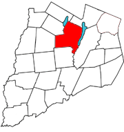
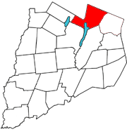
Otsego County is a county in the U.S. state of New York. As of the 2020 census, the population was 58,524. The county seat is Cooperstown. The county's population center is Oneonta. The name Otsego is from a Mohawk or Oneida word meaning "place of the rock."

Otsego County, formerly known as Okkuddo County, is a county located in the U.S. state of Michigan. As of the 2020 Census, the population was 25,091. The county seat is Gaylord. The county was founded in 1840 and organized in 1875.
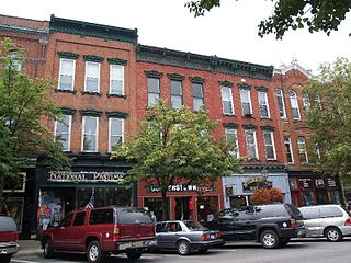
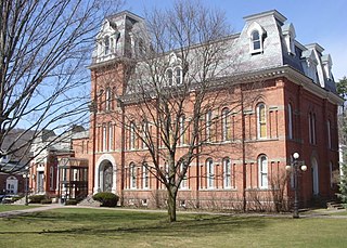
Cooperstown is a village in and the county seat of Otsego County, New York, United States. Most of the village lies within the town of Otsego, but some of the eastern part is in the town of Middlefield. Located at the foot of Otsego Lake in the Central New York Region, Cooperstown is approximately 60 miles southwest of Albany, 67 mi (108 km) southeast of Syracuse and 145 mi (233 km) northwest of New York City. The population of the village was 1,794 as of the 2020 census.
Otsego is a town in the north-central part of Otsego County, New York, United States. The population was 3,900 at the 2010 census. The town is named after Lake Otsego, which forms part of the town's eastern border.
Springfield is a town in Otsego County, New York, United States. The population was 1,358 at the 2010 census.

Otsego Lake is a 4,046-acre (16.37 km2) lake located in Otsego County in the U.S. state of New York. It is the source of the Susquehanna River and largest lake in Otsego County. The Village of Cooperstown is located at the lake's southern end. Glimmerglass State Park is located on the lake's northeastern shore, and includes Hyde Hall, a large mansion constructed in 1817, that overlooks the lake. The Glimmerglass Opera, opened in June 1987, is located on the western shore.

The U.S. state of New York currently comprises 26 congressional districts. Each district elects one member of the United States House of Representatives who sits on its behalf. The state was redistricted in 2022, following the 2020 U.S. census; it lost one seat in Congress.
The Skaneateles Turnpike was an east–west turnpike in central New York in the United States. It began east of the village of Skaneateles and ran east across southern Onondaga and Madison counties to Richfield Springs in northern Otsego County. The road began and ended at the Cherry Valley Turnpike, part of the Great Western Turnpike system, and largely paralleled the Cherry Valley Turnpike between Skaneateles and Richfield Springs. Most of the road is now county-maintained, but a handful of sections are now part of New York state touring routes.

Canadarago Lake is a 1,917-acre (7.76 km2) lake located in Otsego County, New York and is the source of Oaks Creek. The Village of Richfield Springs is located at the lake's northern end. It is the second largest lake in Otsego County, lying to the west of and parallel to the larger Otsego Lake. The lake's name is also spelled "Candajarago Lake" or "Caniadaraga Lake".

New York's 19th congressional district is located in New York's Catskills and mid-Hudson Valley regions. It lies partially in the northernmost region of the New York metropolitan area and mostly south of Albany. This district is currently represented by Republican Marc Molinaro. It was one of 18 districts that voted for Joe Biden in the 2020 presidential election while being won or held by a Republican in 2022.
New York State Route 80 (NY 80) is a 127.32-mile-long (204.90 km) west–east New York State Route located within Onondaga, Madison, Chenango, Otsego, Herkimer, and Montgomery counties in New York. Its western terminus is located at a junction with NY 175 in the city of Syracuse in Onondaga County, from which it actually runs in a north–south direction for 20 miles (32 km). The eastern terminus is located at a junction with NY 5 in the village of Nelliston in Montgomery County. The route is signed north–south from U.S. Route 20 (US 20) north to NY 5.

New York State Route 357 (NY 357) is a 14.02-mile-long (22.56 km) state highway in New York, running from NY 7 in the Otsego County village of Unadilla to NY 28 in the Delaware County town of Franklin.
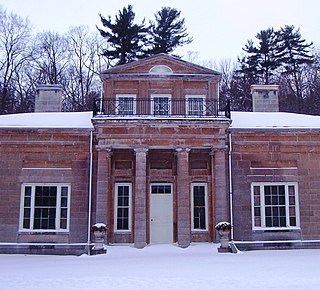
Hyde Hall is a neoclassical country mansion designed by architect Philip Hooker for George Clarke (1768–1835), a wealthy landowner. The house was constructed between 1817 and 1834, and designed with English and American architectural features. It was designated a National Historic Landmark in 1986 for its architecture, and the completeness of its architectural documentary record. It is one of the few surviving works of Philip Hooker, a leading 19th-century American architect.
East Worcester is a hamlet and census-designated place (CDP) in the town of Worcester in Otsego County, New York, United States. It was first listed as a CDP prior to the 2020 census.

Otego Creek is a 32.7-mile-long (52.6 km) tributary of the Susquehanna River in Otsego County, New York. Otego Creek rises in the Town of Otsego and flows south through the Towns of Hartwick and Laurens, before joining the Susquehanna River southwest of the City of Oneonta.

Rum Hill is a mountain located in Central New York Region of New York northwest of the Hamlet of Pierstown. Red House Hill is located southeast, Metcalf Hill is located south, Allen Lake and Mohegan Hill are located north-northwest and Otsego Lake is located east of Rum Hill.
Red House Hill is a mountain in the Central New York Region of New York. It is located south-southwest of the Hamlet of Springfield Center, New York, west of Hutter Point and Six Mile Point of Otsego Lake, and southeast of Rum Hill. Mohican Brook flows eastward along the southern edge of the hill.
Hooker Mountain is a 2,310-foot-tall (700 m) mountain in the Central New York region of New York. It is located in Otsego County northwest of the hamlet of Schenevus. In 1935, a 79-foot-6-inch-tall (24.23 m) fire tower was installed on the mountain by the Civilian Conservation Corps. The tower ceased operations at the end of 1970, and later sold and removed in 1975.
Pierstown is a hamlet located on CR-28 north of Cooperstown and west of Five Mile Point in the Town of Otsego, in Otsego County, New York, United States.

