
Mount Marcy is the highest point in the Adirondack Mountains and the U.S. state of New York, with an elevation of 5,343.1 feet (1,628.6 m). It is located in the town of Keene in Essex County. The mountain is in the heart of the High Peaks Wilderness Area in Adirondack Park. Like the surrounding Adirondack Mountains, Marcy was heavily affected by large glaciers during recent ice ages, which deposited boulders on the mountain slopes and carved valleys and depressions on the mountain. One such depression is today filled by Lake Tear of the Clouds, which is often cited as the highest source of the Hudson River. The majority of the mountain is covered by hardwood and spruce-fir forests, although the highest few hundred feet are above the tree line. The peak is dominated by rocky outcrops, lichens, and alpine plants. The mountain supports a diverse number of woodland mammals and birds.
The Adirondack High Peaks are a set of 46 mountain peaks in the Adirondack Mountains of New York state. They have been popular hiking destinations since the late 1920s, when the list of peaks was published in Russell Carson's book Peaks and Peoples of the Adirondacks. Those who have climbed all 46 High Peaks are eligible to join the Adirondack Forty-Sixers club.

Mount Haystack is a mountain in the Great Range of the Adirondack Mountains of New York. With an elevation of 4,960 feet (1,510 m), it is the third-highest mountain in New York and one of the 46 High Peaks in Adirondack Park. It is located in the town of Keene in Essex County. The first recorded ascent of the mountain was made by mountain guide Orson Schofield Phelps in 1849, accompanied by Almeron Oliver and George Etsy. Phelps gave the mountain its current name based on its appearance to a haystack, and later cut the first trail to the summit in 1873. The summit is an alpine zone above the treeline, which offers a view of nearby Mount Marcy and Panther Gorge.

Mount Skylight is a mountain in the Adirondacks in the U.S. state of New York. Skylight is the fourth-highest peak in New York, with an elevation of 4,924 feet (1,501 m), and one of the 46 High Peaks in Adirondack Park. It is located in the town of Keene in Essex County. The mountain was given its name by artist Frederick S. Perkins and guide Orson Schofield Phelps in 1857, due to a rock formation on the peak resembling a window. Phelps would later make the first known ascent of the peak with surveyor Verplanck Colvin and two others on August 28, 1873.
Dix Mountain is a mountain in the Dix Range of the Adirondacks in the U.S. state of New York. With an elevation of 4,857 feet (1,480 m), it is the sixth-highest peak in New York and one of the 46 Adirondack High Peaks. It is located roughly on the boundary between the towns of North Hudson and Keene in Essex County, and in the High Peaks Wilderness Area of Adirondack Park. The crest of the peak consists of a very narrow ridge, which continues to the southeast and rises to a subsidiary peak named Beckhorn, then continues south to other peaks of the Dix Range. The summit is also in an alpine zone above the treeline. The ridge offers unobstructed views of Elk Lake to the southwest, the Great Range to the northwest, and Lake Champlain and the Green Mountains to the east.

Iroquois Peak is a mountain in the MacIntyre Range of the Adirondacks in the U.S. state of New York. It is the eighth-highest peak in New York, with an elevation of 4,840 feet (1,480 m), and one of the 46 High Peaks in Adirondack Park. It is located in the town of Newcomb in Essex County. Although the mountain does not have an officially maintained trail, a well-maintained herd path marked by cairns exists between the summits of Iroquois Peak and Algonquin Peak, 1.1 miles (1.8 km) to the northeast.

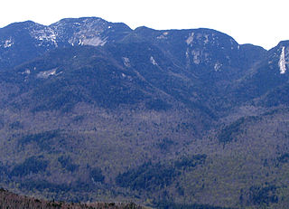
Mount Colden is a mountain in the Adirondacks in the U.S. state of New York. It is the eleventh-highest peak in New York, with an elevation of 4,714 feet (1,437 m), and one of the 46 High Peaks in Adirondack Park. It is located in the town of Keene in Essex County. The peak is named after David C. Colden, an investor in the McIntyre Iron Works at Tahawus. The mountain is known for the Trap Dike, a large crevice that runs from a point near the summit on its west face to nearby Avalanche Lake. The summit of Mount Colden can be reached by two hiking trails, which are frequently combined to form a circuit through Avalanche Pass, or by climbing the Trap Dike. The summit is in an alpine tundra zone above the treeline, and offers views of surrounding mountains and lakes.

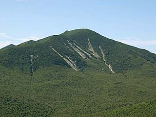
Wright Peak is a mountain in the MacIntyre Range of the Adirondacks in the U.S. state of New York. It is the 16th-highest of the 46 Adirondack High Peaks, with an elevation of 4,580 feet (1,400 m). It is located in the town of North Elba in Essex County. The peak is named after Silas Wright, a New York senator and governor. The mountain is popular for back-country skiing in the winter and features trails to the summit as well as long landslides on its slopes.

Gray Peak is a mountain located in the town of Keene in Essex County, New York. It is the seventh-highest of the Adirondack High Peaks, with an elevation of 4,840 feet (1,480 m), and is located in close proximity to Mount Marcy, the highest peak in New York. Gray Peak is southwest of Mount Marcy and southeast of Mount Colden. The first recorded ascent of the peak was made on September 16, 1872, by surveyor Verplanck Colvin and guide Bill Nye. It was named for Asa Gray by Colvin. Although the mountain is only 0.6 miles (0.97 km) from the summit of Marcy and lacked prominence desired by the Marshall brothers for inclusion in the High Peaks, it was added to the list to preserve the name.

Giant Mountain, also known as Giant of the Valley, is a mountain in the Adirondacks in the U.S. state of New York. It is the twelfth-highest peak in New York, with an elevation of 4,627 feet (1,410 m), and one of the 46 High Peaks in Adirondack Park. It is located in the Giant Mountain Wilderness Area, in the town of Keene in Essex County. The mountain is named for its towering appearance from the nearby Pleasant Valley to the east, which sits at a low elevation.

Rocky Peak Ridge is a mountain in the Adirondacks in the U.S. state of New York. It is the 20th-highest of the Adirondack High Peaks, with an elevation of 4,420 feet (1,350 m). It is located in the Giant Mountain Wilderness Area, in the town of Keene in Essex County. The mountain is named for its appearance as a rocky ridge to the east of the better-known Giant Mountain. Other early names for the mountain included "Giant's Wife", "Bald Mountain", and "Bald Peak", the last of which now belongs to a shorter nearby peak. The earliest recorded ascent of the mountain was made by trail guides Fred J. Patterson and Sam Dunning in 1878. A major forest fire in 1903 burned the topsoil from the top of the mountain and left it with its distinctive bare ridge.

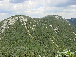
Basin Mountain is a mountain in the Great Range of the Adirondacks in the U.S. state of New York. It is the ninth-highest peak in New York, with an elevation of 4,827 feet (1,471 m), and one of the 46 High Peaks in Adirondack Park. It is located in the town of Keene in Essex County. The peak was named either for the basins formed between knobs on its slopes or the large basin to its southeast formed by it and the surrounding mountains. The name Basin was most likely coined by Orson Schofield Phelps and Frederick W. Perkins in 1857 during an ascent of Mount Marcy. The earliest appearance of the name in writing was made by surveyor Verplanck Colvin in 1873.

Big Slide Mountain is a mountain in the Adirondacks in the U.S. state of New York. It is the 27th-highest of the Adirondack High Peaks, with an elevation of 4,240 feet (1,290 m). The mountain is located in the town of Keene in Essex County. The Johns Brook Valley lies to its east and the South Meadow to its west. The earliest recorded ascent of the mountain was made in 1812 when a surveyor named John Richards was marking the lot lines in Township 12 of the Old Military Tract. The peak was later named for one of two prominent landslides which occurred in 1830 and 1856.

Esther Mountain is a mountain in the Adirondacks in the U.S. state of New York. It is the 28th-highest of the Adirondack High Peaks, with an elevation of 4,240 feet (1,290 m). The mountain is located in the town of Wilmington in Essex County, and is the northernmost of the High Peaks. It was the only High Peak named for a woman until 2014, having been named in honor of Esther McComb, who made the first recorded climb to the summit in 1839, at age 15; at the time she was attempting to climb the adjacent Whiteface Mountain from the north. A tablet commemorating her ascent was placed at the summit of the mountain by the Adirondack Forty-Sixerss in 1939. The name Esther Mountain first appeared in print in 1865.

Nippletop is a mountain in the Colvin Range of the Adirondack Mountains in New York. With an elevation of 4,620 feet (1,410 m), it is the 13th-highest peak in New York and one of the 46 Adirondack High Peaks. It is located near the southern border of the town of Keene in Essex County, in the High Peaks Wilderness Area of Adirondack Park.
Armstrong Mountain is a mountain in the Great Range of the Adirondacks in the U.S. state of New York. It is the 22nd-highest of the Adirondack High Peaks, with an elevation of 4,400 feet (1,300 m). It is located in the town of Keene in Essex County. The mountain is named for Thomas Armstrong, a lumberman from Plattsburgh. In 1866, Armstrong and a business partner, Almon Thomas, purchased the Totten and Crossfield Purchase, which contained the mountain and several of the other High Peaks. Armstrong named the mountain after himself in 1869, although the name was not popularized among local hikers until years later. The earliest recorded ascent was made by Ed Phelps and Thomas P. Wickes in 1875. In 1887, the Totten and Crossfield Purchase was sold to the Adirondack Mountain Reserve.
Saddleback Mountain is a mountain in the Great Range of the Adirondacks in the U. S. state of New York. It is the 17th-highest of the Adirondack High Peaks, with an elevation of 4,515 feet (1,376 m). It is located in Adirondack Park in the town of Keene in Essex County. The mountain was named for the outline of its ridge, which resembles a saddle, by Orson Schofield Phelps and Frederick Perkins. It is flanked by Basin Mountain, the ninth highest of the High Peaks, and Gothics, the tenth highest. Good views of the two higher mountains are offered from the summit of Saddleback. The mountain straddles the watersheds of Johns Brook and the Ausable River. The earliest recorded ascent was made by amateur climber Newell Martin on August 5, 1894. It was claimed that an earlier ascent was made by patent lawyer James J. Storrow and mountain guide Orlando Beede, but the date of this climb is unknown.
Mount Marshall is a mountain in the MacIntyre Range of the Adirondacks in the U.S. state of New York. With an elevation of 4,360 feet (1,330 m), it is the 25th highest mountain in the Adirondacks and one of the 46 High Peaks in Adirondack Park. It is located in the town of Newcomb in Essex County, flanked to the northeast by Cold Brook Pass and Iroquois Peak. Originally named for Governor DeWitt Clinton, and then for mountain guide Herbert Clark, it was renamed for wilderness activist Bob Marshall after his death. The summit can be accessed by hikers on an unmarked trail.

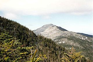
Santanoni Peak is a mountain located in the Santanoni Range of the Adirondacks in the U.S. state of New York. It is the fourteenth-highest peak in New York, with an elevation of 4,607 ft (1,404 m), and one of the 46 High Peaks in Adirondack Park. It is located in the town of Newcomb in Essex County. Santanoni Peak is flanked to the north by Panther Peak and to the northwest by Couchsachraga Peak, the other two mountains of the Santanoni Range. The mountain's name is believed to be an Abenaki derivative of "Saint Anthony"; the first French fur traders and missionaries having named the area for Saint Anthony of Padua. The name first appeared in print in 1838, but may have been used much earlier. The earliest recorded ascent of the mountain was made in 1866 by artist and writer Theodore R. Davis and mountain guide Dave Hunter.
Seward Mountain is a mountain in the Seward Range of the Adirondacks in the U.S. state of New York. It is the 24th-highest of the Adirondack High Peaks, with an elevation of 4,361 feet (1,329 m). The mountain is located in the town of Harrietstown in Franklin County. It is named for New York governor William Seward.


