
The Champlain Valley is a region of the United States around Lake Champlain in Vermont and New York extending north slightly into Quebec, Canada. It is part of the St. Lawrence River drainage basin, drained northward by the Richelieu River into the St. Lawrence at Sorel-Tracy, Quebec. The Richelieu valley is not generally referred to as part of the Champlain Valley.
Blake Peak is a mountain located in Essex County, New York. The mountain is named after Mills Blake, Verplanck Colvin’s chief assistant during the Adirondack Survey. It is part of the Colvin Range. Blake Peak is flanked to the northeast by Mount Colvin, and to the southwest by Pinnacle.
Grace Peak is a mountain located in Essex County, New York. It is part of the Dix Range, named after John A. Dix (1798–1879), New York Secretary of State in 1837, and later Governor. The mountain was formerly called East Dix, but in 2014 it was officially renamed Grace Peak in honor of Grace Hudowalski (1906–2004), who in 1937 became the ninth person and first woman to climb all 46 of the Adirondack High Peaks. Grace Peak is flanked to the northeast by Spotted Mountain, and to the southwest by South Dix.

South Dix is a mountain located in Essex County, New York. The mountain is part of the Dix Range, named after John A. Dix (1798–1879), New York Secretary of State in 1837, and later Governor. The name is being changed to Carson Peak, after Russell M.L. Carson (1884–1961), author of Peaks and People of the Adirondacks. South Dix is flanked to the northeast by Grace Peak, to the northwest by Hough Peak, and to the southwest by Macomb Mountain.

Phelps Mountain is a mountain located in Essex County, New York. The mountain is named after Orson Schofield "Old Mountain" Phelps (1817–1905), who cut the first trail up Mount Marcy and named several of the Adirondack peaks. It is the 32nd highest peak in New York. Phelps Mountain is flanked to the southeast by Table Top Mountain.
Cliff Mountain is a mountain located in Essex County, New York. The mountain is part of the Marcy Group of the Great Range of the Adirondack Mountains. Cliff is flanked to the southeast by Mount Redfield.

Sawteeth is a mountain located in Essex County, New York. The mountain is part of the Great Range of the Adirondack Mountains. The mountain's name comes from the serrated appearance of its summit ridge. Sawteeth is on a spur ridge of the Great Range, which branches off to the southeast from Gothics.

Lower Wolfjaw Mountain is located in Essex County, New York, United States. Landscape artist Alexander Helwig Wyant (1836–1892) named Lower Wolfjaw, together with neighboring Upper Wolfjaw Mountain, about 1870 for their appearance in profile. The mountain is the northeasternmost of the Adirondack High Peaks in the Great Range of the Adirondack Mountains. Lower Wolfjaw Mountain is flanked to the southwest by Upper Wolfjaw Mountain, and to the northeast by Hedgehog Mountain.
Upper Wolfjaw Mountain is a mountain located in Essex County, New York. Landscape artist Alexander Helwig Wyant (1836–1892) named the mountain, in combination with neighboring Lower Wolfjaw Mountain, c. 1870 for their appearance in profile. The mountain is part of the Great Range of the Adirondack Mountains. Upper Wolfjaw Mtn. is flanked to the southwest by Armstrong Mountain, and to the northeast by Lower Wolfjaw Mtn.
Couchsachraga Peak is a mountain located in Essex County, New York. "Couchsachraga" is based on an Algonquin or Huron name for the area, meaning "dismal wilderness". The mountain is part of the Santanoni Range of the Adirondacks. Couchsachraga Peak is flanked to the east by Panther Peak. There is no marked trail to the summit, which, being fully forested, has no views.

Donaldson Mountain is a mountain located in Franklin County, New York, named in 1924 after Alfred Lee Donaldson (1866–1923), author of A History of the Adirondacks. The mountain is part of the Seward Mountains of the Adirondacks. Donaldson Mtn. is flanked to the northeast by Seward Mountain, and to the south by Mount Emmons.

Mount Emmons is a mountain located in the Adirondack Mountains near the southern edge of Franklin County, New York, United States.

Seymour Mountain is a mountain located in Franklin County, New York, named after Horatio Seymour (1810–1886), Governor of New York. The mountain is part of the Seward Mountains of the Adirondacks. Seymour Mountain faces Seward Mountain to the west across Ouluska Pass.
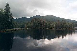
MacNaughton Mountain is a mountain located in Essex County, New York, named after James MacNaughton (1851–1905), the grandson of Archibald McIntyre. The mountain is part of the Street Range of the Adirondack Mountains.
Nye Mountain is a mountain located in Essex County, New York, named after William B. Nye (c.1815–1893), an Adirondack mountain guide. Nye Mountain is part of the Street Range of the Adirondack Mountains; it is flanked to the southwest by Street Mountain.
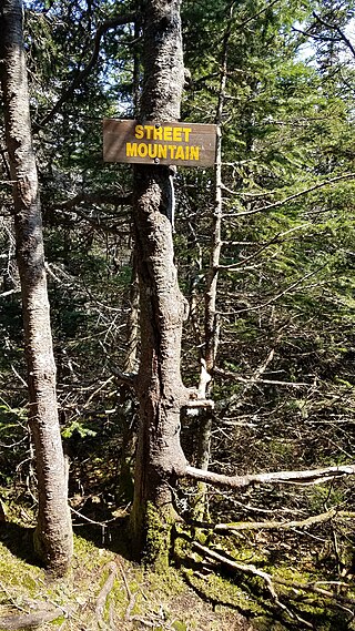
Street Mountain is a mountain located in Essex County, New York, named after Alfred Billings Street (1811–1881), a poet and New York State Librarian. The mountain is the high point of the Street Range of the Adirondack Mountains. Street's northeast ridge is Nye Mountain.

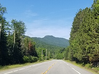
Lyon Mountain is a 3,820 ft (1,160 m) mountain located in Clinton County, New York, the county’s high point. It is named for Nathaniel Lyon, an early settler of the area who moved from Vermont in 1803 and died circa 1850. The mountain is within New York's Adirondack Park.
Snowy Mountain is a mountain located in Hamilton County, New York. Initially known as 'Squaw Bonnet', its summit is the highest point in the county. While most maps show the elevation as 3899 feet, some suggest that more recent surveys have it as 3904 feet or even 3908 feet.
Black Mountain is a mountain located in Washington County, New York, of which its peak is the highest point. Isolated from the rest of the Adirondack Mountains by Lake George, Black Mtn. has the seventh highest topographic prominence of all the mountains in New York. Black Mountain also has the highest elevation of any of the peaks which surround Lake George and offers unobstructed views of the lake from its summit.

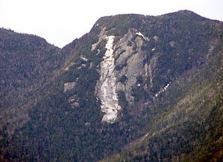
Wallface Mountain is a mountain located in Essex County, New York, United States. The mountain is named after the cliff on its southeastern side. Wallface is flanked to the west by MacNaughton Mountain, and faces Mount Marshall to the southeast across Indian Pass.


