
Mount Adams is a 3,520-foot-tall (1,070 m) mountain located in Essex County of New York. Atop the mountain is the Mount Adams Fire Observation Station, added to the National Register of Historic Places in 2006.
Snowy Mountain is a mountain located in Hamilton County, New York. Initially known as 'Squaw Bonnet', its summit is the highest point in the county. While most maps show the elevation as 3899 feet, some suggest that more recent surveys have it as 3904 feet or even 3908 feet.
Black Mountain is a mountain located in Washington County, New York, of which its peak is the highest point. Isolated from the rest of the Adirondack Mountains by Lake George, Black Mtn. has the seventh highest topographic prominence of all the mountains in New York. Black Mountain also has the highest elevation of any of the peaks which surround Lake George and offers unobstructed views of the lake from its summit.

Ampersand Mountain is a 3,352 ft (1,021.7 m) mountain in Franklin County in the High Peaks Wilderness Area of the northeastern Adirondacks, west of the High Peaks proper in New York State. The trail up the mountain begins on New York State Route 3 8.1 miles (13.0 km) southwest of the village of Saranac Lake, near Middle Saranac Lake; it is a popular day hike. The mountain takes its name from nearby Ampersand Creek, so named because it twists and turns like the ampersand symbol. The summit is bare rock, with extensive views of the High Peaks to the east and the Saranac Lakes to the west. Stony Creek Mountain is located west-southwest of Ampersand Mountain. The mountain is notable as the land surrounding its hiking trail's initial ascent is generally acknowledged as unlogged old growth forest.

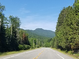
Hurricane Mountain is a 3,688-foot-tall (1,124 m) mountain near Keene in the north of the High Peaks region of the Adirondacks in New York, United States. It is considered to boast some of the most impressive views of any of the lesser peaks; this is due to its prominence, and because its summit was cleared by Verplanck Colvin in the course of his early survey of the Adirondacks. On a clear day, the length of Lake Champlain and the Green Mountains of Vermont are visible to the east, and many of the High Peaks can be seen to the south through the northwest. There is a disused fire tower on the top.
Azure Mountain is a 2,323-foot-tall (708 m) mountain near Blue Mountain Road in the Adirondack Park town of Waverly in Franklin County, New York. Azure Mountain is the site of the Azure Mountain Fire Observation Station, a 35-foot-tall (11 m) steel tower that was built in 1918 and later restored in 2002. The fire tower was listed on the National Register of Historic Places in 2001.

Saint Regis Mountain is a 2,838-foot-tall (865 m) mountain in the town of Santa Clara, New York, in Franklin County at the center of the Saint Regis Canoe Area in the Adirondack Park.
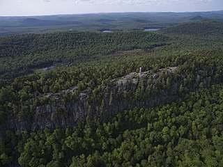
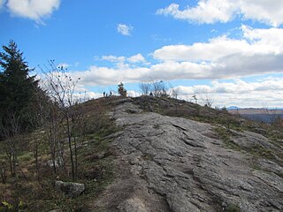
Bald Mountain, or Rondaxe Mountain, is a part of the Adirondack Mountains in the U.S. state of New York. The trail leading up the mountain is a popular hike, likely due to its proximity to tourist towns. The mountain is also home to the Rondaxe Mountain Fire Tower, which contributes to the trail's popularity.
Whites Hill is a 1,427-foot-tall (435 m) mountain in the northern Adirondack Mountains of New York. It is located southeast of Parishville in St. Lawrence County. The mountain is the former site of an 80-foot-tall (24 m) steel fire lookout tower that was in service from 1951 to 1971.
Alma Hill is a 2,543-foot-tall (775 m) mountain in the Southern Tier of New York. It is located southwest of Wellsville in Allegany County. In 1950, an 80-foot-tall (24 m) steel fire lookout tower was built on the mountain. Due to the increased use of aerial detection, the tower ceased fire lookout operations at the end of the 1971 fire lookout season. In 1973, the tower was sold to the landowner where the tower stood. It is the highest hill in western New York, or the highest in New York outside the Adirondacks and Catskills.
Moose River Mountain is a 2,208-foot-tall (673 m) mountain in the Adirondack Mountains of New York. It is located west of Old Forge in the town of Webb in Herkimer County. In 1919, a 60-foot-tall (18 m) steel fire lookout tower was built on the mountain. The tower ceased fire lookout operations at the end of the 1970, and was later removed in 1977.
Palmer Hill is a 1,145-foot-tall (349 m) mountain in the Adirondack Mountains region of New York. It is located north of the hamlet of Au Sable Forks in Clinton County. In 1930, the Conservation Department built a 60-foot-tall (18 m) steel fire lookout tower and an observer cabin on the summit. Due to increased use in aerial detection for fire lookout purposes, the tower ceased fire lookout operations in early 1971. It resumed fire watching operations from 1979 to 1988, before being officially closed in early 1989. The tower still remains, but is on private property and is not open to the public.
West Mountain is a 2,923-foot-tall (891 m) mountain located in Adirondack Mountains of New York. It is located in the northwest of the hamlet of Raquette Lake in Hamilton County. In 1920, the Conservation Commission built a 47-foot-tall (14 m) fire lookout tower on the mountain. Due to aerial detection, the tower ceased fire lookout operations at the end of the 1970 season. The tower was later removed, and portions of the tower along with the tower from Kempshall Mountain were used to build the tower that is at the Essex County Historical Museum in Elizabethtown.
Salmon Lake Mountain is a 2,500-foot-tall (760 m) summit located in Adirondack Mountains of New York. It is located west of the hamlet of Long Lake in Hamilton County. Around 1933, a 35-foot-tall (11 m) Aermotor LX24 tower was built on the mountain. The tower was privately owned, but cooperated with the Conservation Commission for fire watching operations. The tower still remains, but is in poor condition and is not open to the public.
Cathead Mountain is a 2,428-foot-tall (740 m) mountain located in the Adirondack Mountains of New York. It is located north of the hamlet of Benson in Hamilton County. In 1910, a wood fire lookout tower was built on the mountain. In 1916, it was replaced with a 50-foot-tall steel tower. The tower ceased fire lookout operations at the end of the 1988 season and was officially closed in early 1989. Later on, a tower frame was built and attached to the current tower to provide space for radio antennas.
Loon Lake Mountains are a pair of mountains, the tallest being 3,311-foot-tall (1,009 m), near Loon Lake in Franklin County, New York. On the summit is the Loon Lake Mountain Fire Observation Station, which was added to the National Register of Historic Places in 2015.

Goodnow Mountain is a 2,664-foot-tall (812 m) peak in the Adirondack Mountains of New York in the United States. It is the location of the Goodnow Mountain Fire Observation Station. In 1922, the Civilian Conservation Corps built a 60-foot-tall fire tower on the mountain. The tower closed at the end of the 1979 season. The tower was later transferred to SUNY College of Forestry and is now open to the public.
Pharaoh Mountain is a mountain in the Adirondack Mountains region of New York. It is located south of Paradox in Essex County and is contained within the Pharaoh Lake Wilderness Area. The mountain is the highest in the wilderness area, and is located upon the northwest shore of Pharaoh Lake. In April 1910, a fire observation station was established on the mountain but no tower was needed due to lack of tree cover on the mountain. In 1918, a 35-foot-tall Aermotor LS40 tower was built on the mountain. The tower ceased fire watching operations in 1987 and was removed in 1992.

Kempshall Mountain is a 3,350-foot-tall (1,020 m) mountain located in Adirondack Mountains of New York. It is located in the northwest of the hamlet of Long Lake in Hamilton County. In 1918, a 35-foot-tall (11 m) Aermotor LS40 tower was built on the mountain for fire lookout purposes. Due to aerial detection being used, the tower ceased fire lookout operations at the end of the 1971 season. The tower was later removed, and portions of the tower along with the tower from West Mountain were used to build the tower that is at the Essex County Historical Museum in Elizabethtown.
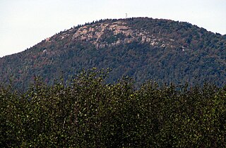
Coney Mountain is a 2,264-foot-tall (690 m) mountain located primarily in the town of Tupper Lake, in the northern part of the Adirondack Mountain Range. It is notable for its prominent bald summit affording widespread views and ease of access in all seasons.


