
The Adirondack Park is a park in northeastern New York protecting the Adirondack Mountains. The park was established in 1892 for "the free use of all the people for their health and pleasure", and for watershed protection. At 6.1 million acres, it is the largest park in the contiguous United States.

Whiteface Mountain is the fifth-highest mountain in the U.S. state of New York, and one of the High Peaks of the Adirondack Mountains, located in the town of Wilmington in Essex County. Set apart from most of the other High Peaks, the summit offers a 360-degree view of the Adirondacks and clear-day glimpses of Vermont and Canada, where Montreal can be seen on a very clear day. Because of its relative isolation, the mountain is exposed to prevailing winds from the west and frequently capped with snow and ice, making it an area of interest to meteorologists. Weather data has been collected on the summit since 1937. The mountain's east slope is home to a major ski area which boasts the greatest vertical drop east of the Rockies, and which hosted the alpine skiing competitions of the 1980 Winter Olympics. Unique among the High Peaks, Whiteface features a developed summit and seasonal accessibility by motor vehicle. The Whiteface Veterans Memorial Highway reaches a parking area at an elevation shortly below the summit, with the remaining distance covered by tunnel and elevator. The peak can also be reached on two hiking trails.
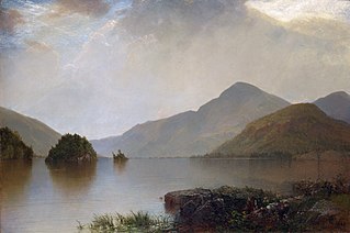
Black Mountain is a mountain located in Washington County, New York, of which its peak is the highest point. Isolated from the rest of the Adirondack Mountains by Lake George, Black Mtn. has the seventh highest topographic prominence of all the mountains in New York. Black Mountain also has the highest elevation of any of the peaks which surround Lake George and offers unobstructed views of the lake from its summit.
Gore Mountain is a mountain located near the village of North Creek in Warren County, New York, of which its peak is the highest point. Gore is flanked to the north by South Mountain, and to the southwest by Height of Land Mountain. The mountain is the site of the popular Gore Mountain ski resort. The mountain is the site of the Gore Mountain Fire Observation Station which was built in 1918.

Ampersand Mountain is a 3,352 ft (1,021.7 m) mountain in Franklin County in the High Peaks Wilderness Area of the northeastern Adirondacks, west of the High Peaks proper in New York State. The trail up the mountain begins on New York State Route 3 8.1 miles (13.0 km) southwest of the village of Saranac Lake, near Middle Saranac Lake; it is a popular day hike. The mountain takes its name from nearby Ampersand Creek, so named because it twists and turns like the ampersand symbol. The summit is bare rock, with extensive views of the High Peaks to the east and the Saranac Lakes to the west. Stony Creek Mountain is located west-southwest of Ampersand Mountain. The mountain is notable as the land surrounding its hiking trail's initial ascent is generally acknowledged as unlogged old growth forest.
Whites Hill is a 1,427-foot-tall (435 m) mountain in the northern Adirondack Mountains of New York. It is located southeast of Parishville in St. Lawrence County. The mountain is the former site of an 80-foot-tall (24 m) steel fire lookout tower that was in service from 1951 to 1971.
Catamount Mountain is a 1,814-foot-tall (553 m) mountain in the Adirondack Mountains of New York. It is located southeast of South Colton in St. Lawrence County. In 1917, a 35-foot-tall (11 m) steel fire lookout tower was built on the mountain. The tower ceased fire lookout operations and was later removed in the early 1980s.
Moose River Mountain is a 2,208-foot-tall (673 m) mountain in the Adirondack Mountains of New York. It is located west of Old Forge in the town of Webb in Herkimer County. In 1919, a 60-foot-tall (18 m) steel fire lookout tower was built on the mountain. The tower ceased fire lookout operations at the end of the 1970, and was later removed in 1977.
Stillwater Mountain is a 2,244-foot-tall (684 m) mountain in Adirondack Mountains of New York. It is located south of Stillwater in the town of Webb in Herkimer County. In 1919, a 47-foot-tall (14 m) steel fire lookout tower was built on the mountain. At the end of the 1988 fire lookout season, the tower ceased fire lookout operation. The tower was restored and is open to the public except from the second Tuesday in October through December 20.
McCarty Hill is a mountain in the Southern Tier of New York. It is located in Cattaraugus County, mostly in Little Valley and Great Valley, with portions in Ellicottville and Mansfield. In 1940, an 82-foot-6-inch-tall (25.15 m) steel fire lookout tower was built on the mountain. The tower ceased fire lookout operations and then officially closed in early 1989. In 1993, the tower was dismantled and removed and replaced with a free-standing communications tower.
Boreas Mountain is a 3,780-foot-tall (1,150 m) mountain in the Adirondack Mountains region of New York. It is located west-northwest of North Hudson in Essex County. In 1919, the Conservation Commission built a 47-foot-tall (14 m) steel fire lookout tower on the mountain. Due to increased use of aerial detection, the tower became obsolete and was closed at the end of the 1971 fire lookout season and later removed.
Palmer Hill is a 1,145-foot-tall (349 m) mountain in the Adirondack Mountains region of New York. It is located north of the hamlet of Au Sable Forks in Clinton County. In 1930, the Conservation Department built a 60-foot-tall (18 m) steel fire lookout tower and an observer cabin on the summit. Due to increased use in aerial detection for fire lookout purposes, the tower ceased fire lookout operations in early 1971. It resumed fire watching operations from 1979 to 1988, before being officially closed in early 1989. The tower still remains, but is on private property and is not open to the public.

Mount Morris is a 3,117-foot-tall (950 m) mountain located in Adirondack Mountains of New York. It is located in the south-southwest of the village of Tupper Lake in Franklin County, and is "the highest peak immediately east of Tupper Lake." It is named after the town in which it was then located.
Makomis Mountain is a 1,631-foot-tall (497 m) mountain located in Adirondack Mountains of New York. It is located west of the hamlet of Witherbee in Essex County. In 1916, a 40-foot-tall (12 m) steel fire lookout tower was built on the mountain. Due to increased use in aerial fire lookout operations, the tower ceased fire lookout operations at the end of the 1970 season, and was later removed.
West Mountain is a 2,923-foot-tall (891 m) mountain located in Adirondack Mountains of New York. It is located in the northwest of the hamlet of Raquette Lake in Hamilton County. In 1920, the Conservation Commission built a 47-foot-tall (14 m) fire lookout tower on the mountain. Due to aerial detection, the tower ceased fire lookout operations at the end of the 1970 season. The tower was later removed, and portions of the tower along with the tower from Kempshall Mountain were used to build the tower that is at the Essex County Historical Museum in Elizabethtown.

Goodnow Mountain is a 2,664-foot-tall (812 m) peak in the Adirondack Mountains of New York in the United States. It is the location of the Goodnow Mountain Fire Observation Station. In 1922, the Civilian Conservation Corps built a 60-foot-tall fire tower on the mountain. The tower closed at the end of the 1979 season. The tower was later transferred to SUNY College of Forestry and is now open to the public.
Tomany Mountain is a 2,589-foot-tall (789 m) mountain in the Adirondack Mountains region of New York. It is located northwest of Arietta in Hamilton County. In 1912, the Conservation Commission built a wooden fire observation tower on the mountain. In 1916, wooden tower was replaced with a 50-foot-tall Aermotor LL25 tower. The tower was closed at the end of the 1970 fire watching season, and later dismantled.
Pharaoh Mountain is a mountain in the Adirondack Mountains region of New York. It is located south of Paradox in Essex County and is contained within the Pharaoh Lake Wilderness Area. The mountain is the highest in the wilderness area, and is located upon the northwest shore of Pharaoh Lake. In April 1910, a fire observation station was established on the mountain but no tower was needed due to lack of tree cover on the mountain. In 1918, a 35-foot-tall Aermotor LS40 tower was built on the mountain. The tower ceased fire watching operations in 1987 and was removed in 1992.
T Lake Mountain is a mountain in the Adirondack Mountains region of New York. It is located north-northwest of Witherbee in Hamilton County. In 1916, the Conservation Commission built a 50-foot-tall (15 m) Aermotor LL25 tower on the mountain. The T Lake Mountain Fire Observation Station ceased fire watching operations at the end of the 1970 season. In 1977, U.S. Army Engineers tested explosive charges on the fire tower which brought the tower crashing down. A few weeks later, the remains of the tower were removed by helicopter.

Kempshall Mountain is a 3,350-foot-tall (1,020 m) mountain located in Adirondack Mountains of New York. It is located in the northwest of the hamlet of Long Lake in Hamilton County. In 1918, a 35-foot-tall (11 m) Aermotor LS40 tower was built on the mountain for fire lookout purposes. Due to aerial detection being used, the tower ceased fire lookout operations at the end of the 1971 season. The tower was later removed, and portions of the tower along with the tower from West Mountain were used to build the tower that is at the Essex County Historical Museum in Elizabethtown.

