
The Appalachian National Scenic Trail, generally known as the Appalachian Trail or simply the A.T., is a marked hiking trail in the Eastern United States extending between Springer Mountain in Georgia and Mount Katahdin in Maine. The trail is about 2,200 miles (3,500 km) long, though the exact length changes over time as parts are modified or rerouted. The Appalachian Trail Conservancy describes the Appalachian Trail as the longest hiking-only trail in the world. More than 2 million people are said to take a hike on part of the trail at least once each year.

The Delaware Water Gap is a water gap on the border of the U.S. states of New Jersey and Pennsylvania where the Delaware River cuts through a large ridge of the Appalachian Mountains. The gap constitutes the southern portion of the Delaware Water Gap National Recreation Area, which is used primarily for recreational purposes, such as rafting, canoeing, swimming, fishing, hiking, and rock climbing.

The Blue Ridge Mountains are a physiographic province of the larger Appalachian Mountains range. The mountain range is located in the eastern United States, and extends 550 miles southwest from southern Pennsylvania through Maryland, West Virginia, Virginia, North Carolina, South Carolina, Tennessee and Georgia. This province consists of northern and southern physiographic regions, which divide near the Roanoke River gap. To the west of the Blue Ridge, between it and the bulk of the Appalachians, lies the Great Appalachian Valley, bordered on the west by the Ridge and Valley province of the Appalachian range.
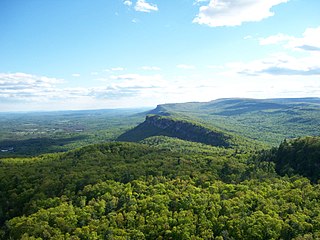
The Shawangunk Ridge, also known as the Shawangunk Mountains or The Gunks, is a ridge of bedrock in Ulster County, Sullivan County and Orange County in the state of New York, extending from the northernmost point of New Jersey to the Catskill Mountains. Shawangunk Ridge is the continuation of the long, easternmost ridge of the Appalachian Mountains; the ridge is known as Kittatinny Mountain in New Jersey, and as Blue Mountain as it continues through Pennsylvania. This ridge constitutes the western border of the Great Appalachian Valley.

Hudson Highlands State Park is a non-contiguous state park in the U.S. state of New York, located on the east side of the Hudson River. The park runs from Peekskill in Westchester County, through Putnam County, to Beacon in Dutchess County, in the eastern section of the Hudson Highlands.

Wawayanda State Park is a 34,350 acres (139.0 km2) state park in Sussex County and Passaic County in northern New Jersey. The park is in Vernon Township on the Sussex side, and West Milford on the Passaic side. There are 60 miles (97 km) of hiking trails in the park, including a 20 miles (32 km) stretch of the Appalachian Trail. The park is operated and maintained by the New Jersey Division of Parks and Forestry. The hiking trails are maintained and updated by the New York - New Jersey Trail Conference.

Blue Mountain Ridge, Blue Mountain, or the Blue Mountains of Pennsylvania is part of the geophysical makeup of the Ridge-and-Valley Appalachians in the U.S. state of Pennsylvania. It is a ridge that forms the southern and eastern edge of the Appalachian mountain range spanning over 255 miles (410 km) from the Delaware Water Gap as it cuts across the eastern half of the state on a slight diagonal from New Jersey tending southerly until it turns southerly curving into Maryland, and beyond.

New York State Route 17A (NY 17A) is a state highway in southern New York in the United States, entirely within Orange County. Its western terminus is located in the village of Goshen at a junction with NY 17, and its eastern terminus is at another intersection with NY 17 located in Southfields. It runs concurrently with NY 94 from Warwick to Florida. It serves mainly to connect Warwick with the rest of the county. While it is an east–west route, many sections run in a more north–south orientation. Its circuitous route allows it to offer much scenery to drivers.

Anthony's Nose is a peak along the Hudson River at the north end of Westchester County, New York.

New Jersey is a state within the United States of America that lies on the north eastern edge of the North American continent. It shares a land border with the state of State of New York along the north, ratified by both states after the New York – New Jersey Line War. New Jersey is slightly larger than the country of Kuwait.
The Appalachian National Scenic Trail spans fourteen U.S. states during its roughly 2,200 miles (3,500 km)-long journey: Georgia, North Carolina, Tennessee, Virginia, West Virginia, Maryland, Pennsylvania, New Jersey, New York, Connecticut, Massachusetts, Vermont, New Hampshire, and Maine. It begins at Springer Mountain, Georgia, and follows the ridgeline of the Appalachian Mountains, crossing many of its highest peaks and running with only a few exceptions almost continuously through wilderness before ending at Mount Katahdin, Maine.

Alander Mountain, 2,239 feet (682 m) is a prominent peak of the south Taconic Mountains; it is located in southwest Massachusetts and adjacent New York. Part of the summit is grassy and open and part is covered with scrub oak and shrubs; the sides of the mountain are wooded with northern hardwood tree species. Views from the top include the southern Taconic Mountains, the Hudson River Valley including the Catskills. Several trails traverse Alander Mountain, most notably the 15.7 mi (25.3 km) South Taconic Trail, which passes just beneath the summit.

Pochuck Mountain is a ridge in the New York-New Jersey Highlands region of the Appalachian Mountains. Pochuck Mountain's summit and most of its peaks lie within Vernon Township, Sussex County, New Jersey, although the south-western portion of the ridge lies within Hardyston Township, and the north-eastern tip of the ridge extends over the New York state line into Orange County. The ridge marks the eastern edge of the Great Appalachian Valley, and it divides the watersheds of the Wallkill River and its tributary Pochuck Creek. The two rivers meet at Pochuck Neck, marking the terminus of the ridge.

Wawayanda Mountain is a ridge in the New York-New Jersey Highlands region of the Appalachian Mountains. The summit lies within Sussex County, New Jersey.

Abram S. Hewitt State Forest is a state forest by Hewitt in northwestern New Jersey that is 2,001 acres (8.10 km2). It is on the Bearfort Ridge of unusual conglomerate between Greenwood Lake and Upper Greenwood Lake. Its forests are part of the Northeastern coastal forests ecoregion. It has a number of overlooks and colorful bedrock. It is accessible only on foot, with trails including the Bearfort Trail, 3.0 miles (4.8 km) and white-blazed. Another trail is the Quail trail, 2.4 miles (3.9 km) and orange-blazed. Another is the Ernest Walter trail, 1.9 miles (3.1 km) and yellow-blazed. Also, the 1.2 miles (1.9 km) State Line trail is blazed with blue on white. Lastly, the Appalachian Trail traverses the forest's northwest corner along its route. The Appalachian Trail is approximately 2,200 miles (3,500 km) long.
Mount Peter is a 1,220-foot (370 m) mountain located in the New York – New Jersey Highlands, Bellvale Mountain, in the U.S. state of New York. The peak is located along the Appalachian Trail in the Town of Warwick, just south of New York State Route 17A, 38 miles (61 km) northwest of New York City, 2 miles (3.2 km) east of Bellvale, New York and north northwest of Greenwood Lake, New York.

The New York – New Jersey Highlands is a geological formation composed primarily of Precambrian igneous and metamorphic rock running from the Delaware River near Musconetcong Mountain, northeast through the Skylands Region of New Jersey along the Bearfort Ridge and the Ramapo Mountains, Sterling Forest, Harriman and Bear Mountain State Parks in New York, to the Hudson River at Storm King Mountain. The northern region is also known as the Hudson Highlands and the southern as the New Jersey Highlands. A broader definition would extend the region west to Reading, Pennsylvania, and east to the Housatonic River in Connecticut, encompassing the Reading Prong.


