The Taconic Mountains or Taconic Range are a range of the Appalachian Mountains, running along the eastern border of New York State and adjacent New England from northwest Connecticut to western Massachusetts, north to central western Vermont. A physiographic region of the larger New England province, the range includes notable summits, including its high point, 3,840 feet (1,170 m) Mount Equinox In Vermont, and 3,489 feet (1,063 m) Mount Greylock, the highest point in Massachusetts.

Hudson Highlands State Park is a non-contiguous state park in the U.S. state of New York, located on the east side of the Hudson River. The park runs from Peekskill in Westchester County, through Putnam County, to Beacon in Dutchess County, in the eastern section of the Hudson Highlands.

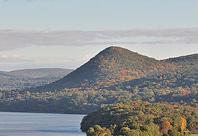
Breakneck Ridge is a mountain along the Hudson River between Beacon and Cold Spring, New York, straddling the boundary between Dutchess and Putnam counties. Its distinctive rocky cliffs are visible for a long distance when approached from the south, and together with Storm King Mountain on the opposite bank of the river forms Wey-Gat, or Wind Gate, the picturesque northern gateway to the Hudson Highlands.

The Hudson Highlands are mountains on both sides of the Hudson River in New York state lying primarily in Putnam County on its east bank and Orange County on its west. They continue somewhat to the south in Westchester County and Rockland County, respectively.
Schunemunk Mountain is the highest mountain in Orange County, New York. The 1,664-foot (507 m) summit is located in the town of Blooming Grove, with other portions in Cornwall and Woodbury. The community of Mountain Lodge Park is built up its western slope.

Anthony's Nose is a peak along the Hudson River at the north end of Westchester County, New York.
The Appalachian National Scenic Trail spans fourteen U.S. states during its roughly 2,200 miles (3,500 km)-long journey: Georgia, North Carolina, Tennessee, Virginia, West Virginia, Maryland, Pennsylvania, New Jersey, New York, Connecticut, Massachusetts, Vermont, New Hampshire, and Maine. The southern end is at Springer Mountain, Georgia, and it follows the ridgeline of the Appalachian Mountains, crossing many of its highest peaks and running almost continuously through wilderness before reaching the northern end at Mount Katahdin, Maine.

The Metacomet Ridge, Metacomet Ridge Mountains, or Metacomet Range of southern New England is a narrow and steep fault-block mountain ridge known for its extensive cliff faces, scenic vistas, microclimate ecosystems, and rare or endangered plants. The ridge is an important recreation resource located within 10 miles (16 km) of more than 1.5 million people, offering four long-distance hiking trails and over a dozen parks and recreation areas, including several historic sites. It has been the focus of ongoing conservation efforts because of its natural, historic, and recreational value, involving municipal, state, and national agencies and nearly two dozen non-profit organizations.

Totoket Mountain, with a high point of (est.) 720 feet (220 m) above sea level, is a traprock massif with several distinct summits, located 7 miles (11 km) northeast of New Haven, Connecticut. It is part of the Metacomet Ridge that extends from the Long Island Sound near New Haven, north through the Connecticut River Valley of Massachusetts to the Vermont border. Totoket Mountain is known for its 500-foot-high (150 m) scenic cliffs, unique microclimate ecosystems, rare plant communities, and for Lake Gaillard, a 2.5-mile-wide (4.0 km) public reservoir nearly enclosed by the mountain. The north ridge of Totoket Mountain is traversed by the 50-mile (80 km) Mattabesett Trail and a significant network of shorter trails. The name "Totoket Mountain" applies to both the entire mountain and to a subordinate northwestern peak.

The Pocumtuck Range, also referred to as the Pocumtuck Ridge, is the northernmost subrange of the Metacomet Ridge mountain range of southern New England. Located in Franklin County, Massachusetts, between the Connecticut River and the Deerfield River valleys, the Pocumtuck Range is a popular hiking destination known for its continuous high cliffs, scenic vistas, and microclimate ecosystems.

Twin Mountain is a mountain located in Greene County, New York. Twin gets its name from its two summits; the lower, 3,590-ft (1,090 m) peak is about .5 miles (0.8 km) to the southeast of the higher. The mountain is part of the Devil's Path range of the Catskill Mountains. To the northwest, Twin Mtn. is separated from Sugarloaf Mountain by Pecoy Notch; to the southeast, Twin Mtn. is separated from Indian Head Mountain by Jimmy Dolan Notch.

Sugarloaf Mountain is a mountain located in Greene County, New York. The mountain is part of the Devil's Path range of the Catskill Mountains. To the northwest, Sugarloaf is separated from Plateau Mountain by Mink Hollow Notch; to the southeast, Sugarloaf is separated from Twin Mountain by Pecoy Notch.

Brace Mountain is the peak of a ridge in the southern Taconic Mountains, near the tripoint of the U.S. states of New York, Connecticut and Massachusetts. Its 2,311-foot (704 m) main summit is located in New York; it is the highest point in that state's Dutchess County.

Alander Mountain, 2,239 feet (682 m), is a prominent peak of the south Taconic Mountains; it is located in southwest Massachusetts and adjacent New York. Part of the summit is grassy and open and part is covered with scrub oak and shrubs; the sides of the mountain are wooded with northern hardwood tree species. Views from the top include the southern Taconic Mountains, the Hudson River Valley including the Catskills. Several trails traverse Alander Mountain, most notably the 15.7 mi (25.3 km) South Taconic Trail, which passes just beneath the summit.

Pochuck Mountain is a ridge in the New York-New Jersey Highlands region of the Appalachian Mountains. Pochuck Mountain's summit and most of its peaks lie within Vernon Township, Sussex County, New Jersey, although the south-western portion of the ridge lies within Hardyston Township, and the north-eastern tip of the ridge extends over the New York state line into Orange County. The ridge marks the eastern edge of the Great Appalachian Valley, and it divides the watersheds of the Wallkill River and its tributary Pochuck Creek. The two rivers meet at Pochuck Neck, marking the terminus of the ridge.

Castle Rock is the estate of former Illinois Central Railroad president William H. Osborn in Garrison, New York, United States. It sits on the hill of the same name, looking down on the Hudson River 620 feet (190 m) below. Visible from West Point across the river and traffic on NY 9D passing through Garrison, it has become one of the most recognizable man-made landmarks of the Hudson Highlands.
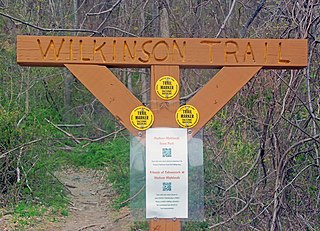
The Wilkinson Memorial Trail is a public footpath in the Hudson Highlands region of the U.S. state of New York. It generally follows the Dutchess–Putnam county line along the latter's northwest corner, from the banks of the Hudson River near Breakneck Ridge to North Highland, just south of the county line in Philipstown. At 9.5 miles (15.3 km) in length it is the longest trail in the Hudson Highlands State Park system; although parts of the trail are on other public and private parcels in the area.

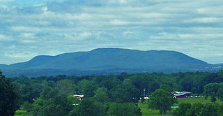
Sugarloaf Mountain is a 900-foot (270 m) peak located in the town of Fishkill near the Hudson River and Breakneck Ridge. One of several similarly named mountains in the U.S. state of New York, it is part of the Hudson Highlands, located entirely within Hudson Highlands State Park.
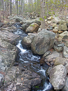
Breakneck Brook, sometimes Breakneck Valley Brook, is a 1.7-mile-long (2.8 km) tributary of the Hudson River located entirely in the Putnam County town of Philipstown, New York, United States. It rises at Surprise Lake and flows southwest towards the Hudson from there, mostly through Hudson Highlands State Park. The name comes from Breakneck Ridge to its north.