
Hancock is a town in Berkshire County, Massachusetts, United States. It is part of the Pittsfield, Massachusetts Metropolitan Statistical Area. The population was 717 at the 2010 census.

Williamstown is a town in Berkshire County, in the northwest corner of Massachusetts, United States. It shares a border with Vermont to the north and New York to the west. It is part of the Pittsfield, Massachusetts Metropolitan Statistical Area. The population was 7,754 at the 2010 census. A college town, it is home to Williams College, the Clark Art Institute and the Tony-awarded Williamstown Theatre Festival.
Mount Greylock is a 3489-foot mountain located in the northwest corner of Massachusetts, the highest point in the state. Its summit is in the western part of the town of Adams in Berkshire County. Although technically it is geologically part of the Taconic Mountains, Mount Greylock is commonly associated with the abutting Berkshire Mountains to the east. The mountain is known for its expansive views encompassing five states and the only taiga-boreal forest in the state. A seasonal automobile road climbs to the summit, topped by a 93-foot-high (28 m) lighthouse-like Massachusetts Veterans War Memorial Tower. A network of hiking trails traverse the mountain, including the Appalachian Trail. Mount Greylock State Reservation was created in 1898 as Massachusetts' first public land for the purpose of forest preservation.

The Berkshires are a highland geologic region located in the western parts of Massachusetts and northwest Connecticut. The term "Berkshires" is normally used by locals in reference to the portion of the Vermont-based Green Mountains that extend south into western Massachusetts; the portion extending further south into northwestern Connecticut is grouped with the Connecticut portion of the Taconic Mountains and referred to as either the Northwest Hills or Litchfield Hills.

The Hoosic River, also known as the Hoosac, the Hoosick and the Hoosuck, is a 76.3-mile-long (122.8 km) tributary of the Hudson River in the northeastern United States. The different spellings are the result of varying transliterations of the river's original Algonquian name. It can be translated either as "the beyond place" or as "the stony place".

The Mohawk Trail began as a Native American trade route which connected Atlantic tribes with tribes in Upstate New York and beyond. It followed the Millers River, Deerfield River and crossed the Hoosac Range, in the area that is now northwestern Massachusetts.

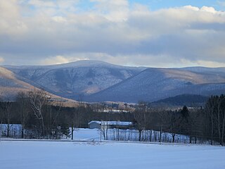
The Taconic Mountains or Taconic Range are a and range of the Appalachian Mountains, running along the eastern border of New York State and adjacent New England from northwest Connecticut to western Massachusetts, north to central western Vermont. A physiographic region of the larger New England province, the range includes notable summits, including its high point, 3,840 feet (1,170 m) Mount Equinox In Vermont, and 3,489 feet (1,063 m) Mount Greylock, the highest point in Massachusetts.
Taconic State Park is located in Columbia and Dutchess County, New York abutting Massachusetts and Connecticut within the Taconic Mountains. The state park is located off New York State Route 344 south of Interstate 90 and 110 miles (180 km) north of New York City. It features camping, hiking, bicycling, hunting, cross county skiing and other recreational opportunities.

The South Taconic Trail is a 21.3 mi (34.3 km) hiking trail in the Taconic Mountains of southwest Massachusetts and adjacent New York. The trail extends from Shagroy Road in Millerton, New York, north along the ridgecrest of the southern Taconic Range and the border of New York and Massachusetts, and ends north of the Catamount Ski Area on Massachusetts Route 23 700 feet (210 m) east of the New York border in Egremont, Massachusetts. The Appalachian Trail, which traverses an adjacent ridgeline in the same mountain range, parallels the South Taconic Trail 3 mi (4.8 km) to the east. The trails are connected to one another via shorter trails.

The Taconic Crest Trail is a 37 mi (60 km) hiking trail in the Taconic Mountains in the northeastern United States. The trail extends from U.S. Route 20 in Hancock, Massachusetts, less than 1 mi (1.6 km) east of the New York border, north along the ridgecrest of the Taconic Range, first within Massachusetts, then weaving along the border of New York and Massachusetts and New York and Vermont, and ending in Petersburgh, New York, on NY Route 346, near the Vermont border. Much of the route has been conserved as state forest, conservation easement, or forest preserve.

Berlin Mountain, 2,818 feet (859 m), is a prominent peak in the Taconic Mountains of western New England and is located adjacent to Massachusetts's border with New York State. It is the highest point in Rensselaer County, and the highest mountain in New York outside the Adirondacks and Catskills. The summit and west side of the mountain are located in New York; the east side lies within Williamstown, Massachusetts. The mountain is a bald, notable for its grassy summit and expansive views of the Hudson River Valley to the west. The 37-mile (60 km) Taconic Crest Trail traverses the mountain. Several other hiking trails approach the summit from the east. Much of the upper slopes and summit are within protected conservation land.
Misery Mountain, 2,671 feet (814 m), with at least ten well-defined summits, is a prominent 6 mi (9.7 km) long ridgeline in the Taconic Mountains of western Massachusetts and adjacent New York. The west side of the mountain is located in New York; the east side and high point lie within Massachusetts. The summit ridge is part meadow and part wooded with red spruce, balsam fir, and northern hardwood tree species. It is notable for its views of the Hudson River Valley to the west. The 35 mi (56 km) Taconic Crest Trail traverses the crest of the ridgeline, but does not cross the summit.

Brodie Mountain, 2,621 feet (799 m), is a prominent 5.5-mile (8.9 km) long ridgeline in the Taconic Mountains of western Massachusetts, known for the former Brodie Mountain ski area, which closed in 2002. The ridge has eight well defined summits, three of which have names: Sheep's Heaven Mountain, 2,530 feet (770 m), the ridge's southern prominatory; Beoadic Mountain, the ridge high point, just north of Sheep's Heaven; and East Mountain, 2,613 feet (796 m) located at the top of the former ski area at the center of the ridge. A northern summit, 2,170 feet (660 m), is shown as "Brodie Mountain" on maps that predate the Brodie Mountain ski area.
Rounds Mountain, 2,257 feet (688 m), is a prominent peak in the Taconic Mountains of western Massachusetts and adjacent New York. The west side of the mountain and summit are located in New York; the east side is located within Massachusetts. The summit a bald; the slopes are wooded with northern hardwood tree species. It is notable for its views of the Hudson River Valley to the west and the Green River and Kinderhook Creek valleys of Hancock, Massachusetts to the east. The 35 mi (56 km) Taconic Crest Trail traverses the mountain. Much of the upper slopes and summit are within protected conservation land.

Brace Mountain is the peak of a ridge in the southern Taconic Mountains, near the tripoint of the U.S. states of New York, Connecticut and Massachusetts. Its 2,311-foot (704 m) main summit is located in New York; it is the highest point in that state's Dutchess County.

Alander Mountain, 2,239 feet (682 m), is a prominent peak of the south Taconic Mountains; it is located in southwest Massachusetts and adjacent New York. Part of the summit is grassy and open and part is covered with scrub oak and shrubs; the sides of the mountain are wooded with northern hardwood tree species. Views from the top include the southern Taconic Mountains, the Hudson River Valley including the Catskills. Several trails traverse Alander Mountain, most notably the 15.7 mi (25.3 km) South Taconic Trail, which passes just beneath the summit.
Mount Fray, 1,893 feet (577 m), also known as Catamount because of the Catamount Ski Area located on its north slope, is a prominent peak of the south Taconic Mountains, located in southwest Massachusetts and adjacent New York. The summit is open and covered in scrub oak; it offers views west over the Hudson River Valley. The sides of the mountain are wooded with northern hardwood tree species. The 15.7 mi (25.3 km) South Taconic Trail passes over the summit of Mount Fray.

Mount Race, 2,365 feet (721 m), is a prominent peak in the south Taconic Mountains of Massachusetts. The mountain is known for its waterfalls, steep, eastern ridgeline cliff face and expansive views of the Housatonic River valley and Berkshires to the east and of fellow Taconics to the south, west and north and Catskills and Hudson River valley to the west, for the traverse of the said cliffline and the summit grounds by the Appalachian Trail and for its old growth pitch pine and scrub oak summit ecosystem.
White Rock, 2,550 feet (780 m), is the high point on a 7 mi (11 km) ridgeline in the Taconic Mountains. The ridge is located in the tri-state corner of New York, Massachusetts, and Vermont in the towns of Petersburgh, Williamstown, and Pownal. The ridge has several distinct knobs; those with names are, from south to north: White Rocks, 2,365 feet (721 m); Smith Hill, 2,330 feet (710 m); White Rock, the high point 2,550 feet (780 m); and Bald Mountain 2,485 feet (757 m). The Snow Hole, located along the ridgeline between Bald Mountain and the White Rock, is a crevasse in which snow can be found well into the summer.
Holy Mount, 1,968 feet (600 m), is a prominent peak in the Taconic Mountains of western Massachusetts, formerly used as the location of religious ceremonies by a nearby Shaker community.
