
The Wind River Range is a mountain range of the Rocky Mountains in western Wyoming in the United States. The range runs roughly NW–SE for approximately 100 mi (160 km). The Continental Divide follows the crest of the range and includes Gannett Peak, which at 13,802 ft (4,207 m), is the highest peak in Wyoming; and also Fremont Peak at 13,750 ft (4,191 m), the third highest peak in Wyoming. There are more than 40 other named peaks in excess of 12,999 ft (3,962 m). With the exception of the Grand Teton in the Teton Range, the next 19 highest peaks in Wyoming after Gannett are also in the Winds.

The Taconic Mountains are a 150-mile-long sub-range of the Appalachian Mountains lying on the eastern border of New York State and adjacent New England. The range, which played a role in the history of geological science, is separated from the Berkshires and Green Mountains to the east by a series of valleys, principally those of the Housatonic River, Battenkill River and Otter Creek. The Taconics' highest point is Mount Equinox in Vermont at 3,840 feet (1,170 m); among many other summits are Dorset Mountain, Mount Greylock and Mount Everett.

Whiteface Mountain is the fifth-highest mountain in the U.S. state of New York, and one of the High Peaks of the Adirondack Mountains, located in the town of Wilmington in Essex County. Set apart from most of the other High Peaks, the summit offers a 360-degree view of the Adirondacks and clear-day glimpses of Vermont and Canada, where Montreal can be seen on a very clear day. Because of its relative isolation, the mountain is exposed to prevailing winds from the west and frequently capped with snow and ice, making it an area of interest to meteorologists. Weather data has been collected on the summit since 1937. The mountain's east slope is home to a major ski area which boasts the greatest vertical drop east of the Rockies, and which hosted the alpine skiing competitions of the 1980 Winter Olympics. Unique among the High Peaks, Whiteface features a developed summit and seasonal accessibility by motor vehicle. The Whiteface Veterans Memorial Highway reaches a parking area at an elevation shortly below the summit, with the remaining distance covered by tunnel and elevator. The peak can also be reached on two hiking trails.

Vredehoek is a residential suburb of Cape Town, South Africa, located at the foot of Table Mountain and Devil's Peak. It is sandwiched between the two neighbouring suburbs of Oranjezicht and Devil's Peak Estate, the latter of which is often considered a sub-suburb of Vredehoek as they both fall under the neighbourhood watch community called DPV - Devil's Peak & Vredehoek.
Poor Mountain is a ridge of high peaks located in Roanoke County, Virginia and Montgomery County, Virginia. At 3,928 feet, Poor Mountain is the tallest mountain in the immediate area.

Equinox Mountain is the highest peak of the Taconic Range and the second-highest point in southern Vermont, after Stratton Mountain. It rises nearly 3,000 feet above its eastern footings in Manchester, giving Equinox the third-greatest topographic prominence among the state's mountains. A summit observation building is reached via a privately operated toll road, which passes near various towers used for broadcast and other purposes.

Lizard Head Peak is in the southern Wind River Range in the U.S. state of Wyoming. Situated in Shoshone National Forest, Lizard Head Peak is the northeasternmost peak in the Cirque of the Towers, a popular climbing area. Lizard Head Glacier is just WNW of the peak.

Hoosac Wind Power Project is a wind farm on Crum Hill in Monroe, Massachusetts and on Bakke Mountain in Florida, Massachusetts. Owned and operated by Iberdrola Renewables, it is the largest wind farm in Massachusetts, with 19 GE 1.5 MW wind turbines and a total installed capacity of 28.5 MW. The Hoosac Wind power project became fully operational in 2012 and provides enough electricity to power 10,000 homes annually.

Mount Warren is located in the Wind River Range in the U.S. state of Wyoming. The peak is the third peak in the range and the fourth tallest in Wyoming. The summit is located in the Fitzpatrick Wilderness of Shoshone National Forest and rises above several glaciers, the best known being Dinwoody Glacier which is immediately north of the summit tower. The mountain abuts, but is not within, either Bridger National Forest or Sublette County, Wyoming.

Mount Helen is located in the Wind River Range in the U.S. state of Wyoming. The peak is the fourth highest peak in the range and the fifth tallest in Wyoming. The summit is located in the Bridger Wilderness of Bridger-Teton National Forest, immediately west of the Continental Divide. The eastern flanks of the mountain are covered in snowfields and glaciers, including Helen and Sacagawea Glaciers, all of which are in the Fitzpatrick Wilderness of Shoshone National Forest.
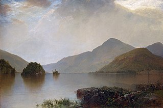
Black Mountain is a mountain located in Washington County, New York, of which its peak is the highest point. Isolated from the rest of the Adirondack Mountains by Lake George, Black Mtn. has the seventh highest topographic prominence of all the mountains in New York. Black Mountain also has the highest elevation of any of the peaks which surround Lake George and offers unobstructed views of the lake from its summit.

Berlin Mountain is a 2,818-foot-tall (859 m) prominent peak in the Taconic Mountains of western New England and is located adjacent to Massachusetts's border with New York State. It is the highest point in Rensselaer County. The summit and west side of the mountain are located in New York; the east side lies within Williamstown, Massachusetts. The mountain is a bald, notable for its grassy summit and expansive views of the Hudson River Valley to the west. The 37-mile (60 km) Taconic Crest Trail traverses the mountain. Several other hiking trails approach the summit from the east. Much of the upper slopes and summit are within protected conservation land. Historically the lower slopes of the mountain were farmed heavily throughout the 19th Century. In addition to agriculture, there are several remnants of charcoal kilns located on the mountain that produced fuel for iron smelting.

The Red Hill Fire Observation Station consists of a fire lookout tower, cabin and pit privy located on the summit of Red Hill, a 2,990-foot (910 m) Catskill Mountain peak in Denning, New York, United States. It is the southernmost fire tower in the Catskill Park.

The Weeks Estate is a historic country estate on U.S. Route 3 in Lancaster, New Hampshire. Built in 1912 for John Wingate Weeks, atop Prospect Mountain overlooking the Connecticut River, it is one of the state's best preserved early 20th-century country estates. It was given to the state by Weeks' children, and is now Weeks State Park. It features hiking trails, expansive views of the countryside from the stone observation tower, and a small museum in the main estate house. A small portion of property at the mountain summit was listed on the National Register of Historic Places in 1985, while the park as a whole was listed in 2023.

Spruce Mountain, located in eastern West Virginia, is the highest ridge of the Allegheny Mountains. The whale-backed ridge extends for only 16 miles (26 km) from northeast to southwest, but several of its peaks exceed 4,500 feet (1,400 m) in elevation. The summit, Spruce Knob, is the highest Allegheny Mountain point both in the state and the entire range, which spans four states.
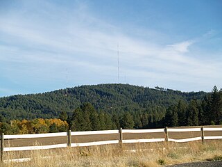
Krell Hill, also known as Tower Mountain, is a peak at the southern end of the Selkirk Mountains in Spokane County, Washington. It rises abruptly to the southeast of the relatively flat South Hill area of the city of Spokane. An area of high topographical relief continues to the east of the mountain towards Mica Peak and the Coeur d'Alene Mountains of the Bitterroot Range, in turn part of the Rocky Mountains. To the north the mountain descends slowly along a ridge, and then into the lower Dishman Hills and eventually into Spokane Valley. To the south and west the mountain towers over relatively flat terrain, with the vast farmland of the Palouse and the Columbia Plateau extending as far as the eye can see.

Above All State Park is an undeveloped public recreation area located in the town of Warren, Connecticut. Remnants of a Cold War-era military radar installation may be seen. The only park amenities are informal trails not maintained by the Connecticut Department of Energy and Environmental Protection.
Ferncliff Forest is a 200-acre (0.81 km2) old-growth forest preserve of deciduous and hemlock trees located in Rhinebeck, a town in the northern part of Dutchess County, New York, US. The property had been bought in 1900 by John Jacob Astor IV and remained in the Astor family until 1964, when it was donated as a forest preserve and game refuge.
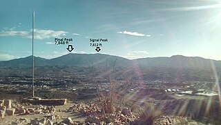
Pinal Peak, located in southern Gila County, Arizona, is the highest point in the Pinal Mountains, with an elevation of 7,848 feet (2,392 m). It is the highest point of land located in between the Salt and Gila rivers in Arizona before they merge, making it visible from miles away on a clear day. The peak ranks as the 11th most prominent in Arizona and has a topographic isolation of 35 miles (56 km), with the nearest point of land of equal or greater elevation being to the southeast in the Santa Teresa Mountains. Pinal Peak is slightly east of the approximate center of the Pinal Mountains. Despite being the most prominent peak in Gila County, it is not the highest point in the county. That title goes to Myrtle Point with an elevation between 7,963 and 8,003 feet (2,427–2,439 m), which lies atop the edge of the Mogollon Rim which forms the county line with Coconino County. The nearest population is in the Globe/Miami, Arizona area, just a few miles north of the range and peak.

Utsayantha Mountain is a 3,209-foot-tall (978 m) mountain in the Catskill Mountains of New York. It is located east-southeast of Stamford in Delaware County. Variant names include Utsayanthe Mountain, Utsayanthia Mountain, Utsayantho Mountain, and Utsyantha Mountain. McGregor Mountain is located southeast of Utsayantha Mountain and Churchill Mountain is located southwest. Utsayantha Mountain is named after Utsayantha, the daughter of Chief Ubiwacha, chief of the Lenape Indians.
