
Mount Holyoke, a traprock mountain, elevation 935 feet (285 m), is the westernmost peak of the Holyoke Range and part of the 100-mile (160 km) Metacomet Ridge. The mountain is located in the Connecticut River Valley of western Massachusetts, and is the namesake of nearby Mount Holyoke College. The mountain is located in the towns of Hadley and South Hadley, Massachusetts. It is known for its historic summit house, auto road, scenic vistas, and biodiversity. The mountain is crossed by the 110-mile (180 km) Metacomet-Monadnock Trail and numerous shorter trails. Mount Holyoke is the home of J.A. Skinner State Park which is accessible from Route 47 in Hadley, Massachusetts.

South Hadley is a town in Hampshire County, Massachusetts, United States. The population was 18,150 at the 2020 census. It is part of the Springfield, Massachusetts Metropolitan Statistical Area.

The Pioneer Valley is the colloquial and promotional name for the portion of the Connecticut River Valley that is in Massachusetts in the United States. It is generally taken to comprise the three counties of Hampden, Hampshire, and Franklin. The lower Pioneer Valley corresponds to the Springfield, Massachusetts metropolitan area, the region's urban center, and the seat of Hampden County. The upper Pioneer Valley region includes the smaller cities of Northampton and Greenfield, the county seats of Hampshire and Franklin counties, respectively.

The Green Mountains are a mountain range in the U.S. state of Vermont and are a subrange of the Appalachian Mountains. The range runs primarily south to north and extends approximately 250 miles (400 km) from the border with Massachusetts to the border with Quebec, Canada. The part of the same range that is in Massachusetts and Connecticut is known as The Berkshires or the Berkshire Hills and the Quebec portion is called the Sutton Mountains, or Monts Sutton in French.

Western Massachusetts, known colloquially as "western Mass," is a region in Massachusetts, one of the six U.S. states that make up the New England region of the United States. Western Massachusetts has diverse topography; 22 colleges and universities including UMass in Amherst, MA, with approximately 100,000 students; and such institutions as Tanglewood, the Springfield Armory, and Jacob's Pillow.

Mount Moosilauke is a 4,802-foot-high (1,464 m) mountain at the southwestern end of the White Mountains in the town of Benton, New Hampshire, United States. It is the tenth highest and most southwesterly of the 4,000 foot summits in the White Mountains.
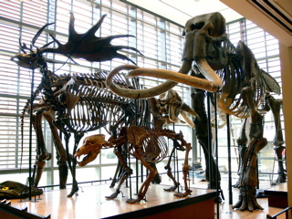
The Beneski Museum of Natural History, Amherst College, is located on the campus of Amherst College in Amherst, Massachusetts. It showcases fossils and minerals collected locally and abroad, many by past and present students and professors. The museum is located in the Beneski Earth Sciences Building, completed in 2006. It is a member of Museums10.

The Metacomet-Monadnock Trail is a 114-mile-long (183 km) hiking trail that traverses the Metacomet Ridge of the Pioneer Valley region of Massachusetts and the central uplands of Massachusetts and southern New Hampshire. Although less than 70 miles (110 km) from Boston and other large population centers, the trail is considered remarkably rural and scenic and includes many areas of unique ecologic, historic, and geologic interest. Notable features include waterfalls, dramatic cliff faces, exposed mountain summits, woodlands, swamps, lakes, river floodplain, farmland, significant historic sites, and the summits of Mount Monadnock, Mount Tom and Mount Holyoke. The Metacomet-Monadnock Trail is maintained largely through the efforts of the Western Massachusetts Chapter of the Appalachian Mountain Club (AMC). Much of the trail is a portion of the New England National Scenic Trail.

Mount Everett is the highest peak in the south Taconic Mountains, rising about 2,000 feet above its eastern footings in Sheffield, Mass. Its summit area is notable for expansive vistas and an unusual dwarf forest of pitch pine and oak. The Appalachian Trail traverses Mount Everett, which prior to the 20th century was called "Dome of the Taconics." Reaching 2,602 feet above sea level, Everett dominates much local scenery of the Housatonic Valley.

Route 116 is a 68.26-mile-long (109.85 km) north–south state highway in Massachusetts. The route runs from Route 20A in Springfield through mill towns, college towns and rural towns, crossing the Connecticut River three times before finally ending at Route 8 in Adams.
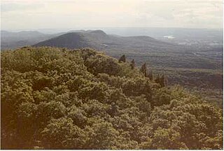
The Seven Sisters, part of the Holyoke Range and located within the Pioneer Valley region of Massachusetts, United States, are a series of basalt ridgeline knobs between Mount Holyoke and Mount Hitchcock. The knobs offer scenic clifftop views interspersed with oak savanna woodlands. The highest "sister" has an elevation of 1,005 ft (306 m) and stands 800 ft (244 m) above the valley below. The terrain is very rugged; a continuous walk along the ridgeline includes an overall elevation change of 3,700 ft (1,128 m). The Seven Sisters are traversed by the Metacomet-Monadnock Trail and is part of the New England National Scenic Trail

The Metacomet Ridge, Metacomet Ridge Mountains, or Metacomet Range of southern New England is a narrow and steep fault-block mountain ridge known for its extensive cliff faces, scenic vistas, microclimate ecosystems, and rare or endangered plants. The ridge is an important recreation resource located within 10 miles (16 km) of more than 1.5 million people, offering four long-distance hiking trails and over a dozen parks and recreation areas, including several historic sites. It has been the focus of ongoing conservation efforts because of its natural, historic, and recreational value, involving municipal, state, and national agencies and nearly two dozen non-profit organizations.

The Holyoke Range or Mount Holyoke Range is a traprock mountain range located in the Connecticut River Valley of Massachusetts. It is a subrange of the narrow, linear Metacomet Ridge that extends from Long Island Sound near New Haven, Connecticut, north through the Connecticut River Valley of Massachusetts to the Vermont border. It is also a subrange of the Appalachian Mountains. A popular hiking destination, the range is known for its anomalous east–west orientation, high ledges and its scenic character. It is also notable for its unique microclimate ecosystems and rare plant communities, as well as significant historic sites, such as the Mount Holyoke Summit House and the Horse Caves.

Mount Norwottuck or Mount Norwottock, 1,106 feet (337 m) above sea level, is the highest peak of the Holyoke Range of traprock mountains located in the Connecticut River Valley of Massachusetts and part of the greater Metacomet Ridge which stretches from Long Island Sound to nearly the Vermont border. The peak rises steeply from the valley 1,000 feet (300 m) below and offers sweeping views of the surrounding countryside. It is located within the towns of Amherst and Granby, Massachusetts.
Bare Mountain, 1,014 feet (309 m) above sea level, is a prominent peak of the Holyoke Range of traprock mountains located in the Connecticut River Valley of Massachusetts, and part of the greater Metacomet Ridge that stretches from Long Island Sound to nearly the Vermont border. The peak rises steeply from the river valley 1,000 feet (300 m) below; its bald summit offers sweeping views. Bare Mountain is located within the towns of Amherst and South Hadley, Massachusetts. Part of its northeastern flanks are in Hadley and part of its southern flanks are in Granby. It is traversed by the 110-mile (180 km) Metacomet-Monadnock Trail.
The Robert Frost Trail is a 47-mile (76 km) long footpath that passes through the eastern Connecticut River Valley of Massachusetts. The trail runs from the Connecticut River in South Hadley, Massachusetts to Ruggles Pond in Wendell State Forest, through both Hampshire and Franklin County and includes a number of scenic features such as the Holyoke Range, Mount Orient, Puffer's Pond, and Mount Toby. The trail is named after the poet Robert Frost, who lived and taught in the area from 1916 to 1938.

Dinosaur Footprints in Holyoke, Massachusetts, USA is an 8-acre (3 ha) wilderness reservation purchased for the public in 1935 by The Trustees of Reservations. The Reservation is currently being managed with the assistance from the Massachusetts Department of Conservation and Recreation (DCR). The fossil and plant resources on the adjacent Holyoke Gas and Electric (HG&E) riverfront property are being managed cooperatively by The Trustees, Mass DCR, and HG&E.
Long Mountain, 920 feet (280 m) feet above sea level, is a traprock mountain of the Holyoke Range, part of the greater Metacomet Ridge which stretches from Long Island Sound to nearly the Vermont border. The mountain rises steeply from the surrounding landscape 600 feet (180 m) below and consists of five distinct peaks, from east to west: 685 feet (209 m), 775 feet (236 m), 795 feet (242 m), 920 feet (280 m), the high point, and the eastern summit, 906 feet (276 m). It is located within the towns of Amherst and Granby, Massachusetts. The 110-mile (180 km) Metacomet-Monadnock Trail and the 47-mile (76 km) Robert Frost Trail traverse the mountain. The Holyoke Range continues to the west as Mount Norwottuck and to the east as Harris Mountain.

Round Mountain, 780 feet (238 m) above sea level, was a peak of the Holyoke Range of traprock mountains located in the Connecticut River Valley of Massachusetts, and part of the greater Metacomet Ridge that stretches from Long Island Sound nearly to the Vermont border. Round Mountain was located mostly within Granby but some land was within the towns of Amherst and South Hadley, Massachusetts. It was traversed by the 110-mile (180 km) Metacomet-Monadnock Trail, but no longer, since the trail has been moved at that point to the north to avoid the quarry.

Dwight is an unincorporated, historical village in North Belchertown, Massachusetts, United States, named for the family. It was a railroad destination and farming community in the 19th century with lumber mills, grist mills, schools, a chapel, cemeteries, two railway depots, aquatic gardens, restaurants, ballrooms, inns, a silk mill, a carding mill, a woodturning mill, an apiary, a cider mill, a carriage-maker, wheelwright, gunsmith and blacksmith, a general store and post office. Today the community is known for its natural beauty, scenic waterfalls, wildlife, forests, ponds, lakes, brooks, springs, hiking trails, and bike paths.
