
Mount Adams is a 3,520-foot-tall (1,070 m) mountain located in Essex County of New York. Atop the mountain is the Mount Adams Fire Observation Station, added to the National Register of Historic Places in 2006.
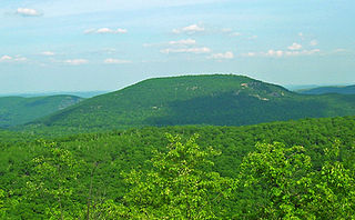
Bear Mountain is one of the best-known peaks of New York's Hudson Highlands. Located partially in Orange County in the town of Highlands and partially in Rockland County in the town of Stony Point, it lends its name to the nearby Bear Mountain Bridge and Bear Mountain State Park that contains it.

Alander Mountain is a 2,241-foot-tall (683 m) part of the south Taconic Mountains in southwest Massachusetts and adjacent to New York. The summit is grassy and covered with scrub oak and shrubs; the sides of the mountain are heavily forested. Several trails traverse Alander Mountain, most notably is the 15.7 mi (25.3 km) South Taconic Trail, which passes just beneath the summit.
Azure Mountain is a 2,323-foot-tall (708 m) mountain near Blue Mountain Road in the Adirondack Park town of Waverly in Franklin County, New York. Azure Mountain is the site of the Azure Mountain Fire Observation Station, a 35-foot-tall (11 m) steel tower that was built in 1918 and later restored in 2002. The fire tower was listed on the National Register of Historic Places in 2001.
Crane Mountain is a 3,251-foot-tall (991 m) mountain in the Adirondack Mountains of New York. It is located northwest of Warrensburg in Warren County. The mountain is the former site of a 35-foot-tall (11 m) steel fire lookout tower. The tower was installed in 1918, and later removed in 1987.
Catamount Mountain is a 1,814-foot-tall (553 m) mountain in the Adirondack Mountains of New York. It is located southeast of South Colton in St. Lawrence County. In 1917, a 35-foot-tall (11 m) steel fire lookout tower was built on the mountain. The tower ceased fire lookout operations and was later removed in the early 1980s.
Moose River Mountain is a 2,208-foot-tall (673 m) mountain in the Adirondack Mountains of New York. It is located west of Old Forge in the town of Webb in Herkimer County. In 1919, a 60-foot-tall (18 m) steel fire lookout tower was built on the mountain. The tower ceased fire lookout operations at the end of the 1970, and was later removed in 1977.
Stillwater Mountain is a 2,244-foot-tall (684 m) mountain in Adirondack Mountains of New York. It is located south of Stillwater in the town of Webb in Herkimer County. In 1919, a 47-foot-tall (14 m) steel fire lookout tower was built on the mountain. At the end of the 1988 fire lookout season, the tower ceased fire lookout operation. The tower was restored and is open to the public except from the second Tuesday in October through December 20.
Woodhull Mountain is a 2,359-foot-tall (719 m) mountain in the Adirondack Mountains of New York. It is located east-southeast of Minnehaha in the Town of Webb in Herkimer County. In 1916, a 50-foot-tall (15 m) steel fire lookout tower was built on the mountain. The tower ceased fire lookout operations at the end of the 1970 season. The tower still remains and is open to the public with the exception of the tower cab.
Bald Mountain is a 1,647-foot-tall (502 m) mountain in Lewis County in the state of New York. It is located north of Oswegatchie Camp in the town of Croghan. In 1919, a 47-foot-tall (14 m) steel fire lookout tower was built on the mountain. Due to increased use of aerial detection, the tower was closed at the end of the 1970 season. The tower was later knocked over by the private owner due to liability concerns. The public can visit the site, but due to no tower there is no view.
Boreas Mountain is a 3,780-foot-tall (1,150 m) mountain in the Adirondack Mountains region of New York. It is located west-northwest of North Hudson in Essex County. In 1919, the Conservation Commission built a 47-foot-tall (14 m) steel fire lookout tower on the mountain. Due to increased use of aerial detection, the tower became obsolete and was closed at the end of the 1971 fire lookout season and later removed.
Mount Irvine is a mountain in the Southern Tier of New York. It is located in Carrollton, northwest of Limestone in Cattaraugus County. In 1928, a 60-foot-tall (18 m) steel fire lookout tower was built on the mountain. Three years later, the tower was moved to Science Hill.
Salmon Lake Mountain is a 2,500-foot-tall (760 m) summit located in Adirondack Mountains of New York. It is located west of the hamlet of Long Lake in Hamilton County. Around 1933, a 35-foot-tall (11 m) Aermotor LX24 tower was built on the mountain. The tower was privately owned, but cooperated with the Conservation Commission for fire watching operations. The tower still remains, but is in poor condition and is not open to the public.
Cathead Mountain is a 2,428-foot-tall (740 m) mountain located in the Adirondack Mountains of New York. It is located north of the hamlet of Benson in Hamilton County. In 1910, a wood fire lookout tower was built on the mountain. In 1916, it was replaced with a 50-foot-tall steel tower. The tower ceased fire lookout operations at the end of the 1988 season and was officially closed in early 1989. Later on, a tower frame was built and attached to the current tower to provide space for radio antennas.
Jackie Jones Mountain is a 1,253-foot-tall (382 m) mountain in the state of New York. It is located west of Stony Point in Rockland County. In 1928, a 60-foot-tall (18 m) steel fire lookout tower was built on the mountain. The tower ceased fire lookout operations at the end of the 1988 fire lookout season, and was officially closed in early 1989. The tower is listed on the National Historic Lookout Register, and is open to the public.
Ohmer Mountain is a 2,572-foot-tall (784 m) mountain in the Adirondack Mountains of New York. It is located northeast of Northville in Saratoga County.
Leonard Hill is a 2,592-foot-tall (790 m) mountain in Schoharie County, New York. It is located east-southeast of North Blenheim. Safford Hill is located northwest and Hubbard Hill is located southeast of Leonard Hill. In 1948, the Conservation Commission built an 80-foot-tall (24 m) steel fire lookout tower on the mountain. The tower ceased fire watching operations at the end of the 1988 season and was officially closed in early 1989. The tower remains on the summit, but is closed to the public. A local group is planning to restore the tower and reopen it to the public.

Swede Mountain is a mountain in the Adirondack Mountains region of New York. It is located southwest of Ticonderoga and north of Glens Falls in Warren County. The Swede Mountain Fire Observation Station is located on top of the mountain.
Washburn Mountain is a 1,496-foot-tall (456 m) mountain in New York. It is located south-southeast Copake Falls in Columbia County. From 1932 to 1964, the mountain was the location of a 60-foot-tall (18 m) steel fire lookout tower now located on Beebe Hill. Alander Mountain is located southeast of Washburn Mountain.
Mount Tuscarora is a mountain in the Southern Tier of New York. It is in Allegany State Park in Coldspring, Cattaraugus County. In 1928, a 60-foot-tall (18 m) steel fire lookout tower was built on the mountain. The tower remains on the mountain but needs to be restored. The peak is the tallest in the Allegany State Park among those that have a trail to the summit, at 2,144 ft above sea level.

