
Otsego County is a county in the U.S. state of New York. As of the 2020 census, the population was 58,524. The county seat is Cooperstown. The county's population center is Oneonta. The name Otsego is from a Mohawk or Oneida word meaning "place of the rock." The county is part of the Mohawk Valley region of the state.
Maryland is a town in Otsego County, New York, United States. The population was 1,897 at the 2010 census. It was named for the U.S. state of the same name. The Town of Maryland is on the county's southern border. It is northeast of the City of Oneonta.
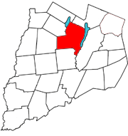
Otsego is a town in the north-central part of Otsego County, New York, United States. The population was 3,641 at the 2020 census. The town is named after Lake Otsego, which forms part of the town's eastern border.
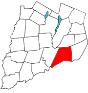
Worcester is a town in Otsego County, New York, United States. The population was 2,220 at the 2010 census. Worcester is on the southeastern border of the county and is northeast of Oneonta. The Worcester Central School District presently has 369 students enrolled in grades K-12.
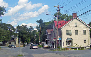
Schenevus is a hamlet in the town of Maryland in southeastern Otsego County, New York, United States. According to the 2010 census, the population was 551. The Schenevus Central School district covers the towns of Maryland, Westford, Milford, Decatur and Roseboom. The Schenevus Carousel and Twentieth Century Steam Riding Gallery No. 409 are listed on the National Register of Historic Places.
New York State Route 23 (NY 23) is an east–west state highway in the eastern portion of New York in the United States. It extends for 156.15 miles (251.30 km) from an intersection with NY 26 in the Central New York town of Cincinnatus in Cortland County to the Massachusetts state line in the Berkshire Mountains, where it continues east as that state's Route 23. Along the way, it passes through many communities, including the cities of Norwich and Oneonta. Outside of the communities, the route serves largely rural areas of the state and traverses the Catskill Mountains in the state's Central New York Region. NY 23 crosses the Hudson River at Catskill via the Rip Van Winkle Bridge.
Salisbury Mills is a hamlet and census-designated place (CDP) in the towns of Blooming Grove and Cornwall in Orange County, New York, United States. As of the 2020 census, it had a population of 580.

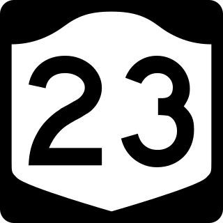
New York State Route 205 (NY 205) is a 23.24-mile-long (37.40 km) north–south state highway in central Otsego County, New York, in the United States. It extends from Interstate 88 (I-88) at exit 13 near the city of Oneonta to a junction with NY 28 and NY 80 in the town of Otsego. The latter junction also marks the east end of a 2.1-mile (3.4 km) overlap between NY 205 and NY 80, from where NY 80 heads southeast to follow NY 28 to Cooperstown. NY 205 is a two-lane highway for its entire length and passes through the towns of Oneonta, Laurens and Hartwick.
Central Bridge is a hamlet and census-designated place (CDP) within the towns of Schoharie and Esperance in Schoharie County, New York, United States. As of the 2020 census, the population was 740.
Coopers Plains is a hamlet and census-designated place (CDP) in the towns of Erwin and Campbell in Steuben County, New York, United States. As of the 2010 census, it had a population of 598.
Worcester is a census-designated place (CDP) forming the central settlement of the town of Worcester in Otsego County, New York, United States. The population of the CDP was 986 at the 2020 census.
Busti is a hamlet and census-designated place in the town of Busti in Chautauqua County, New York, United States. The population was 391 at the 2010 census, out of a total population in the town of 7,351.

Sunset Bay is a hamlet and census-designated place (CDP) in the town of Hanover in Chautauqua County, New York, United States. The population was 660 at the 2010 census.
Wilmington is a hamlet and census-designated place (CDP) in the town of Wilmington in Essex County, New York, United States. The population of the CDP was 843 at the 2020 census, out of a total town population of 880.
Rodman is a hamlet and census-designated place (CDP) in the town of Rodman, Jefferson County, New York, United States. As of the 2010 census, the CDP population was 153, out of 1,176 in the entire town of Rodman.
New Baltimore is the primary hamlet in the town of New Baltimore, Greene County, New York, United States. It is a census-designated place (CDP), first listed as such prior to the 2020 census. The New Baltimore Hamlet Historic District occupies the historic core of the hamlet.
White Lake is a census-designated place (CDP) in the town of Forestport, Oneida County, New York, United States. It was first listed as a CDP prior to the 2020 census.
Westford is a census-designated place (CDP) and the primary hamlet in the town of Westford, Otsego County, New York, United States. It was first listed as a CDP prior to the 2020 census.
South Ilion is a hamlet and census-designated place (CDP) in the town of German Flatts in Herkimer County, New York, United States. It was first listed as a CDP prior to the 2020 census.
Clintondale is an unincorporated community and census-designated place (CDP) in Clinton County, Pennsylvania, United States. It was first listed as a CDP prior to the 2020 census.


