Decatur, New York

Last updated

Decatur, New York
Otsego County outline map Decatur red.png
Decatur, Otsego County, NY
Coordinates: 42°40′13″N74°42′4″W / 42.67028°N 74.70111°W / 42.67028; -74.70111
Country United States
State New York
County Otsego
Area
[1]
  Total20.76 sq mi (53.76 km2)
  Land20.56 sq mi (53.26 km2)
  Water0.20 sq mi (0.51 km2)
Elevation
2,100 ft (640 m)
Population
 (2010)
  Total353
  Estimate 
(2016) [2]
339
  Density16.49/sq mi (6.37/km2)
Time zone UTC-5 (Eastern (EST))
  Summer (DST) UTC-4 (EDT)
ZIP code
12197
Area code 607
FIPS code 36-19895
GNIS feature ID0978890

The Town of Decatur is located on the eastern border of Otsego County, New York, United States. As of the 2010 U.S. census, it had a population of 353. It is named after the popular early-American naval hero Stephen Decatur. [3]

Contents

History

Early settlers began arriving in 1790, settling at the present Decatur village. Decatur was formed from part of the Town of Worcester in 1808. Its surface is hilly, broken by narrow valleys. The principal streams are Oak and Parker Creek, a tributary to the Schenevus. The first settlement was made in 1790 by Jacob Kinney near the present village of Decatur. The first merchant in the town was Nahum Thompson, who was a member of the assembly in 1844. The first supervisor was David Tripp, and the first town clerk was Lemuel Fletcher. Samuel Turber taught the first school in about the year 1798. The first grist mill was erected by John Champion, the grandfather of S.B. Champion, editor of the Stamford Mirror. James Stewart built the first carding mill. [4]

Jacob Brown and his son Jacob came from Columbia county in 1787. Nathan and Gardner Boorn were early settlers. Amos, a son of Gardner, was supervisor for six years. The brothers Elisha, John and Samuel Waterman, came from Norwich, Connecticut, soon after the Revolution. From Elisha was descended Lewis Edson Waterman, inventor of the "Waterman Ideal Fountain Pen", who was born in Decatur in 1837, and died in Brooklyn, New York in 1900. [ citation needed ]

Geography

According to the United States Census Bureau, the town has a total area of 20.8 square miles (54 km2), of which 20.6 square miles (53 km2) is land and 0.2 square miles (0.52 km2) (0.87%) is water.

The eastern town line is the border of Schoharie County.

Notable people

Demographics

Historical population
CensusPop.Note
1820 926
1830 1,11019.9%
1840 1,071−3.5%
1850 927−13.4%
1860 902−2.7%
1870 802−11.1%
1880 779−2.9%
1890 597−23.4%
1900 559−6.4%
1910 476−14.8%
1920 422−11.3%
1930 336−20.4%
1940 324−3.6%
1950 279−13.9%
1960 254−9.0%
1970 28110.6%
1980 31211.0%
1990 35614.1%
2000 41015.2%
2010 353−13.9%
2016 (est.)339 [2] −4.0%
U.S. Decennial Census [5]

As of the census [6] of 2000, there were 410 people, 158 households, and 117 families residing in the town. The population density was 19.9 people per square mile (7.7/km2). There were 281 housing units at an average density of 13.6 per square mile (5.3/km2). The racial makeup of the town was 98.78% White, 0.24% African American, 0.24% Asian, 0.49% from other races, and 0.24% from two or more races. Hispanic or Latino of any race were 1.46% of the population.

There were 158 households, out of which 29.1% had children under the age of 18 living with them, 66.5% were married couples living together, 4.4% had a female householder with no husband present, and 25.9% were non-families. 19.6% of all households were made up of individuals, and 10.1% had someone living alone who was 65 years of age or older. The average household size was 2.59 and the average family size was 2.99.

In the town, the population was spread out, with 23.9% under the age of 18, 6.1% from 18 to 24, 23.7% from 25 to 44, 29.0% from 45 to 64, and 17.3% who were 65 years of age or older. The median age was 42 years. For every 100 females, there were 115.8 males. For every 100 females age 18 and over, there were 105.3 males.

The median income for a household in the town was $29,896, and the median income for a family was $38,125. Males had a median income of $29,219 versus $21,458 for females. The per capita income for the town was $16,541. About 2.6% of families and 4.4% of the population were below the poverty line, including 7.8% of those under age 18 and none of those age 65 or over.

Communities and locations in Decatur

Related Research Articles

Hume is a town in Allegany County, New York, United States. The population was 2,094 at the 2020 census. The town is on the northern border of Allegany County.

<span class="mw-page-title-main">Dayton, New York</span> Town in New York, United States

Dayton is a town in Cattaraugus County, New York, United States. The population was 1,689 at the 2020 census. The town is on the western border of Cattaraugus County.

Davenport is a town in Delaware County, New York, United States. The population was 2,965 at the 2010 census. The town is in the northeastern part of the county.

<span class="mw-page-title-main">East Fishkill, New York</span> Town in New York, United States

East Fishkill is a town on the southern border of Dutchess County, New York, United States. The population was 29,707 at the 2020 census. Until its creation in 1849, the town was the eastern portion of the town of Fishkill.

Lincoln is a town in Madison County, New York, United States. The population was 2,012 at the 2010 census.

<span class="mw-page-title-main">Sangerfield, New York</span> Town in New York, United States

Sangerfield is a town in Oneida County, New York, United States. The population was 2,561 at the 2010 census. The town is named after Jedediah Sanger, an early settler.

<span class="mw-page-title-main">Mount Hope, New York</span> Town in New York, United States

Mount Hope is a town in the northwestern part of Orange County, New York, United States, west of Middletown. The northern town line is the border of Sullivan County. The population was 6,537 at the 2020 census.

<span class="mw-page-title-main">Plainfield, New York</span> Town in New York, United States

Plainfield is a town in Otsego County, New York, United States. The population was 915 at the 2010 census.

<span class="mw-page-title-main">Westford, New York</span> Town in New York, United States

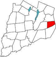
Westford is a town in Otsego County, New York, United States. The population was 868 at the 2010 census. It is southeast of Cooperstown.
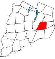
<span class="mw-page-title-main">Seward, New York</span> Town in New York, United States

Seward is a town in Schoharie County, New York, United States. The population was 1,637 at the 2000 census. The town is named after senator, governor, and secretary of state William H. Seward.

<span class="mw-page-title-main">Fowler, New York</span> Town in New York, United States

Fowler is a town in St. Lawrence County, New York, United States. The population was 2,202 at the 2010 census.

<span class="mw-page-title-main">Rossie, New York</span> Town in New York, United States

Rossie is a town in St. Lawrence County, New York, United States. The population was 877 at the 2010 census. The town is named after the sister of an early land owner.

Thurston is a town in Steuben County, New York, United States. The population was 1,248 at the 2020 United States census. The town is named after early landowner William Thurston.

Woodhull is a town in Steuben County, New York, United States. The population was 1,719 at the time of the 2010 United States Census.

<span class="mw-page-title-main">Thompson, New York</span> Town in New York, United States

Thompson is a town in the southern part of Sullivan County, New York, United States. The population was 16,550 at the 2020 census. The town is named after William Thompson, an early settler.

<span class="mw-page-title-main">Hartford, New York</span> Town in New York, United States

Hartford is a town centrally located in Washington County, New York, United States. It is part of the Glens Falls Metropolitan Statistical Area. The town population was 2,279 at the 2000 census.

<span class="mw-page-title-main">Ontario, New York</span> Town in Wayne County, New York, US

Ontario is a town in the northwest corner of Wayne County, New York, United States. The population was 9,778 at the 2000 census, and 10,136 at the 2010 census. The town is named after the Great Lake on its northern border.

Van Etten is a town in Chemung County, New York, United States. It is part of the Elmira Metropolitan Statistical Area. The population of the town was 1,541 at the 2020 census. The town is named for the two brothers who founded the village of Van Etten in it. The town is at the northeastern corner of the county, northeast of Elmira.

Brownville is a town in Jefferson County, New York, United States. The population was 6,263 at the 2010 census, up from 5,839 in 2000. The town is named after Jacob Brown, an early settler and leader.

<span class="mw-page-title-main">Hermon, New York</span> Town in New York, United States

Hermon is a town in St. Lawrence County, New York, United States. The population was 1,108 at the 2010 census. Hermon is named after Mount Hermon in Israel, which is the name corresponding to Mount Jabal al-Sheikh in Syria. The town contains a hamlet also called Hermon, and is in the south-central part of the county, southwest of Canton.

References

  1. "2016 U.S. Gazetteer Files". United States Census Bureau. Retrieved July 5, 2017.
  2. 1 2 "Population and Housing Unit Estimates" . Retrieved June 9, 2017.
  3. Gannett, Henry (1905). The Origin of Certain Place Names in the United States. Govt. Print. Off. pp.  102.
  4. "Historic Decatur". City of Decatur, GA. Retrieved August 19, 2022.
  5. "Census of Population and Housing". Census.gov. Retrieved June 4, 2015.
  6. "U.S. Census website". United States Census Bureau . Retrieved January 31, 2008.