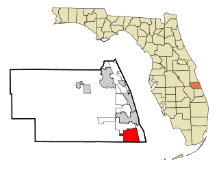
Florida Ridge is a census-designated place (CDP) in Indian River County, Florida, United States. The population was 18,164 at the 2010 census.

Timberlane is a village in Boone County, Illinois, United States. It is part of the Rockford, Illinois Metropolitan Statistical Area. The population was 906 at the 2020 census.
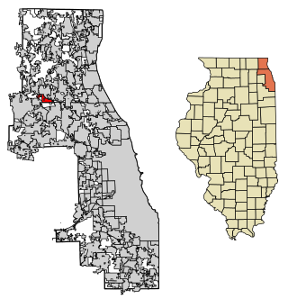
Deer Park is a village in Lake and Cook Counties, Illinois. Per the 2020 census, the population was 3,681. The village is one of the few left in the Chicago area that enjoy a green belt which is bordered by two large natural areas providing outdoor recreation and open space. The village is home to popular shopping and dining destinations: Deer Park Town Center and the Town Center Promenade. The town is also home to the Vehe Farm, an Illinois Centennial Farm.

Island Lake is a village in Lake and McHenry counties in the U.S. state of Illinois. Per the 2020 census, the population was 8,051. The village surrounds Island Lake, a lake which contains a small island.

Colesburg is a city in Delaware County, Iowa, United States. The population was 386 at the time of the 2020 census.

Ironton is a city in Crow Wing County, Minnesota, United States. The population was 572 at the 2010 census. It is part of the Brainerd Micropolitan Statistical Area.

Cliff Village is a village in Newton County, Missouri, United States. The population was 40 at the 2010 census. It is part of the Joplin, Missouri Metropolitan Statistical Area.

Springview is a village in, and the county seat of, Keya Paha County, Nebraska, United States. The population was 242 at the 2010 census.

Roaming Shores is a village in Ashtabula County, Ohio, United States. The population was 1,586 at the 2020 census.

Woodstock is a village in Champaign County, Ohio, United States. The population was 287 at the 2020 census.

Chatfield is a village in Crawford County, Ohio, United States. The population was 205 at the 2020 census.
Valley View is a village in Cuyahoga County, Ohio, United States. The population was 1,897 at the 2020 census. A suburb of Cleveland, it is a part of the Cleveland metropolitan area.
Monroeville is a village in Huron County, Ohio, United States. The population was 1,300 at the 2020 census.

Spring City is a borough in Chester County, Pennsylvania, United States. The population was 3,494 at the 2020 census. Spring City is a member of the Spring-Ford Area School District.

Browntown is a village in Green County, Wisconsin, United States. The population was 280 at the 2010 census.

Rowley is a census-designated place (CDP) in the town of Rowley in Essex County, Massachusetts, United States. The population was 1,416 at the 2010 census.
Smyrna is a village in Chenango County, New York, United States. The population was 213 at the 2010 census. The village is located in the town of Smyrna and is near the northern border of Chenango County.
Laurens is a village in Otsego County, New York, United States. The population was 263 at the 2010 census.

Otego is a town in Otsego County, New York, United States. The population was 3,115 at the 2010 census. The name is a native word meaning "where there is fire."

Otego Township is one of twenty townships in Fayette County, Illinois, USA. As of the 2020 census, its population was 1,445 and it contained 626 housing units. Its name changed from Cumberland township on September 24, 1860. Overcup Church is located in this township.

