Unadilla (village), New York

Last updated

Unadilla, New York
UnadillaNYengraving.jpg
USA New York location map.svg
Red pog.svg
Unadilla, New York
Location within the state of New York
Coordinates: 42°19′36″N75°18′54″W / 42.32667°N 75.31500°W / 42.32667; -75.31500
CountryUnited States
State New York
County Otsego
Area
[1]
  Total1.09 sq mi (2.81 km2)
  Land1.04 sq mi (2.68 km2)
  Water0.05 sq mi (0.13 km2)
Elevation
1,010 ft (308 m)
Population
 (2020)
  Total1,065
  Density1,027.00/sq mi (396.70/km2)
Time zone UTC-5 (Eastern (EST))
  Summer (DST) UTC-4 (EDT)
ZIP code
13849
Area code 607
FIPS code 36-76001
GNIS feature ID0968118

Unadilla is a village located in the Town of Unadilla in Otsego County, New York, United States. The population was 1,128 at the 2010 census.

Contents

The Village of Unadilla is located in the southern part of the town, southwest of Oneonta. The community refers to itself as "The Village Beautiful."

History

The town was originally the site of a Seneca Indian village at the confluence of the Susquehanna and Unadilla Rivers, where the village of Sidney (in Delaware County) is now located. The name Unadilla, which represents one spelling from a number of different interpretations of several Iroquois dialects, is said to mean "Meeting Place", indicating the place where two rivers meet.

Unadilla was first settled by whites around 1770. The location of the village now called Unadilla was first settled about the same time by a group of Scots-Irish at the junction of the Ouleout Creek and the Susquehanna River. Both villages were destroyed by the Continental Army in October 1778 because they were being used by Loyalists as a base for raiding frontier communities.

Shortly thereafter, Unadilla Village was again settled, and originally called "Wattles Ferry," It grew after it became an important stop for travel west: the Catskill Turnpike crossed the Susquehanna at Wattles Ferry, located in the eastern end of the village. Eventually, the turnpikes were replaced in importance by the Albany and Susquehanna Railroad (later the Delaware and Hudson Railway). The small community continued to take advantage of this progress and prosper.

Unadilla incorporated as a village in 1827, finally incorporated in 1889.

The village contains many historical homes, some built before the Civil War.

Unadilla's Boy Scout Troop #1 was chartered in 1910, and is recognized as the oldest continuously operating troop in the United States.

The Unadilla Village Historic District and Roswell Wright House are listed on the National Register of Historic Places. [2]

Notable person

Geography

Unadilla is located at 42°19′36″N75°18′53″W / 42.32667°N 75.31472°W / 42.32667; -75.31472 (42.326694, -75.314863). [3]

According to the United States Census Bureau, the village has a total area of 1.1 square miles (2.8 km2), all land.

The corner of Main Street and Bridge Street in the village of Unadilla, New York. Village of Unadilla, New York.jpg
The corner of Main Street and Bridge Street in the village of Unadilla, New York.

The Village of Unadilla is located in Otsego County, adjacent to the Susquehanna River by the county line shared with Delaware County. The village is about three miles upstream from the Village of Sidney located in Delaware County. The Village of Unadilla is located in the south part of the Town of Unadilla on New York Route 7 (Main Street) and north of Interstate 88.

Demographics

Historical population
CensusPop.Note
1870 875
1880 9225.4%
1890 1,15725.5%
1900 1,1721.3%
1910 1,009−13.9%
1920 1,15714.7%
1930 1,063−8.1%
1940 1,0791.5%
1950 1,31722.1%
1960 1,58620.4%
1970 1,489−6.1%
1980 1,367−8.2%
1990 1,265−7.5%
2000 1,127−10.9%
2010 1,1280.1%
2020 1,065−5.6%
U.S. Decennial Census [4]

As of the census [5] of 2000, there were 1,127 people, 470 households, and 314 families residing in the village. The population density was 1,045.2 inhabitants per square mile (403.6/km2). There were 542 housing units at an average density of 502.7 per square mile (194.1/km2). The racial makeup of the village was 97.07% White, 0.53% Black or African American, 0.18% Native American, 0.09% Asian, 0.09% Pacific Islander, 1.42% from other races, and 0.62% from two or more races. Hispanic or Latino of any race were 1.06% of the population.

There were 470 households, out of which 30.2% had children under the age of 18 living with them, 48.7% were married couples living together, 13.2% had a female householder with no husband present, and 33.0% were non-families. 28.1% of all households were made up of individuals, and 13.8% had someone living alone who was 65 years of age or older. The average household size was 2.40 and the average family size was 2.91.

In the village, the population was spread out, with 24.5% under the age of 18, 9.8% from 18 to 24, 25.5% from 25 to 44, 23.2% from 45 to 64, and 17.0% who were 65 years of age or older. The median age was 40 years. For every 100 females, there were 92.0 males. For every 100 females age 18 and over, there were 87.4 males.

The median income for a household in the village was $34,886, and the median income for a family was $39,097. Males had a median income of $29,808 versus $22,500 for females. The per capita income for the village was $19,687. About 11.1% of families and 10.8% of the population were below the poverty line, including 20.7% of those under age 18 and 2.1% of those age 65 or over.

Related Research Articles

<span class="mw-page-title-main">Otsego County, New York</span> County in New York, United States

Otsego County is a county in the U.S. state of New York located within the Mohawk Valley Region. As of the 2020 census, the population was 58,524. The county seat is Cooperstown. The county's population center is Oneonta. The name Otsego is from a Mohawk or Oneida word meaning "place of the rock."

<span class="mw-page-title-main">Columbus, New York</span> Town in New York, United States

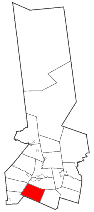
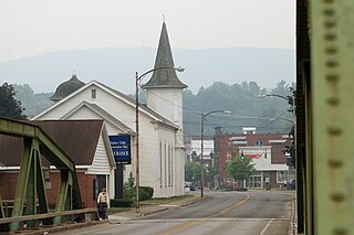
Columbus is a town in Chenango County, New York, United States. The population was 975 at the 2010 census. Columbus is in the northeastern corner of the county and is northeast of Norwich.

Harpersfield is a town in Delaware County, New York, United States. The population was 1,577 at the 2010 census. The town is on the northern border of the county.

Meredith is a town in Delaware County, New York, United States. The population was 1,529 at the 2010 census. It is an interior town in the northern part of the county.

<span class="mw-page-title-main">Columbia, New York</span> Town in New York, United States

Columbia is a town in Herkimer County, New York, United States. As of the 2010 census, the town population was 1,580. The town is at the southern border of the county and is southeast of Utica.

<span class="mw-page-title-main">Winfield (town), New York</span> Town in New York, United States

Winfield is a town in Herkimer County, New York, United States. The population was 2,086 at the 2010 census. The town is named after General Winfield Scott and is in the southwestern corner of the county, south of Utica.

<span class="mw-page-title-main">Gilbertsville, New York</span> Village in New York, United States

Gilbertsville is a historic village in Otsego County, New York, United States. The population was 399 at the 2010 census. The Village of Gilbertsville is in the Town of Butternuts and is west of Oneonta.
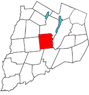
<span class="mw-page-title-main">Pittsfield, New York</span> Town in New York, United States

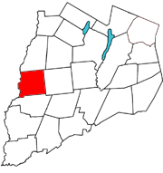
Pittsfield is a town in Otsego County, New York, United States. The population was 1,366 at the 2010 census.

<span class="mw-page-title-main">Plainfield, New York</span> Town in New York, United States

Plainfield is a town in Otsego County, New York, United States. The population was 915 at the 2010 census.

New Berlin is a village in Chenango County, New York, United States. The population was 1,028 at the 2010 census. The village is by the eastern town line of the town of New Berlin and is northeast of Norwich.

<span class="mw-page-title-main">New Berlin, New York</span> Town in New York, United States

New Berlin is a town in Chenango County, central New York, United States. The population was 2,682 at the 2010 census. The town contains the village of New Berlin. The town is at the eastern border of the county and is northeast of Norwich.

Franklin is a village in Delaware County of the U.S. state of New York. As of the 2010 census, the village population was 374. The village is in the town of Franklin.

<span class="mw-page-title-main">Sidney (village), New York</span> Village in New York, United States

Sidney is a village in Delaware County, New York, United States. The population was 3,900 at the 2010 census. The village is in the western part of the town of Sidney.

Sidney is a town in Delaware County, New York, United States. The population was 5,774 at the 2010 census. The town is at the northwestern corner of the county and contains the village of Sidney a very small Town on NY Rte 7, home of the famous Unadilla laminated wood products manufactured by Unalam Inc and Amphenol Aerospace manufacturing.

<span class="mw-page-title-main">Milford, New York</span> Town in New York, United States

Milford is a town in Otsego County, New York, United States. The population was 3,044 at the 2010 census. Within town is the village of Milford. The town is northeast of the City of Oneonta.

Morris is a village in Otsego County, New York, United States. The population was 583 at the 2010 census.

<span class="mw-page-title-main">Oneonta (town), New York</span> Town in New York, United States

Oneonta is a town in Otsego County, New York, United States. The population was 5,065 at the 2020 census.,

Otego is a village in Otsego County, New York, United States. It is located within the Mohawk Valley Region of the state. The population was 1,010 at the 2010 census.

<span class="mw-page-title-main">Otego (town), New York</span> Town in New York, United States

Otego is a town in Otsego County, New York, United States. The population was 3,115 at the 2010 census. The name is a native word meaning "where there is fire."

<span class="mw-page-title-main">Unadilla, New York</span> Town in New York, United States

Unadilla is a town in Otsego County, New York, United States. As of the 2010 census, the town had a population of 4,392. The name is derived from an Iroquois word for "meeting place". Unadilla is located in the southwestern corner of the county, southwest of Oneonta. The village of Unadilla is located in the southern part of the town. The mayor of Unadilla is Jason Cotten.

References

  1. "ArcGIS REST Services Directory". United States Census Bureau. Retrieved September 20, 2022.
  2. "National Register Information System". National Register of Historic Places . National Park Service. March 13, 2009.
  3. "US Gazetteer files: 2010, 2000, and 1990". United States Census Bureau. February 12, 2011. Retrieved April 23, 2011.
  4. "Census of Population and Housing". Census.gov. Retrieved June 4, 2015.
  5. "U.S. Census website". United States Census Bureau . Retrieved January 31, 2008.