
Otsego County is a county in the U.S. state of New York. As of the 2020 census, the population was 58,524. The county seat is Cooperstown. The county's population center is Oneonta. The name Otsego is from a Mohawk or Oneida word meaning "place of the rock." The county is part of the Mohawk Valley region of the state.
Brookfield is a town in Madison County, New York, United States. The population was 2,247 at the 2020 census, down from 2,545 in 2010.

Butternuts is a town located in Otsego County, New York, United States. As of the 2010 census, the town had a population of 1,786. The Town of Butternuts is located in the southwestern part of the county, and is west of Oneonta.
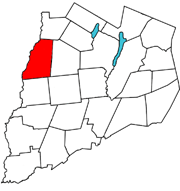
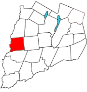
Edmeston is a town located in Otsego County, New York, United States. As of the 2010 census, the town had a total population of 1,826.
Pittsfield is a town in Otsego County, New York, United States. The population was 1,366 at the 2010 census.

Plainfield is a town in Otsego County, New York, United States. The population was 915 at the 2010 census.

Unadilla is a village located in the town of Unadilla in Otsego County, New York, United States. The population was 1,128 at the 2010 census. The village is located in the southern part of the town, southwest of Oneonta. The community nickname is, "The Village Beautiful."

Unadilla is a town in Otsego County, New York, United States. As of the 2010 census, the town had a population of 4,392. The name is derived from an Iroquois word for "meeting place". Unadilla is located in the southwestern corner of the county, southwest of Oneonta. The village of Unadilla is located in the southern part of the town. The mayor of Unadilla is Jason Cotten.

The Unadilla River is a 71-mile-long (114 km) river in the Central New York Region of New York State. The river begins northeast of the hamlet of Millers Mills and flows generally south to the village of Sidney, where it converges with the Susquehanna River, which drains into the Chesapeake Bay, a bay of the Atlantic Ocean.

General William Edmeston was a British Army officer who owned an estate in New York State.
The Skaneateles Turnpike was an east–west turnpike in central New York in the United States. It began east of the village of Skaneateles and ran east across southern Onondaga and Madison counties to Richfield Springs in northern Otsego County. The road began and ended at the Cherry Valley Turnpike, part of the Great Western Turnpike system, and largely paralleled the Cherry Valley Turnpike between Skaneateles and Richfield Springs. Most of the road is now county-maintained, but a handful of sections are now part of New York state touring routes.
Percifer Carr was a British allied Loyalist living in what is now Otsego County, New York around the time of the American Revolution.

South Edmeston is a hamlet on the Unadilla River in the Town of Edmeston in Otsego County, New York, United States.

Wharton Creek is a 36.1-mile-long (58.1 km) tributary of the Unadilla River in western Otsego County, in the state of New York. Via the Unadilla River, it is part of the Susquehanna River watershed, flowing to Chesapeake Bay.

West Burlington is a hamlet in the western part of the Town of Burlington in Otsego County, New York, United States. It is located at 42.7075°N 75.1877°W, three miles (4.8 km) east of the town of Edmeston on NY 51 and NY 80.
Unadilla Forks is a hamlet in the Town of Plainfield in Otsego County, New York, United States, at the confluence of the two branches of the Unadilla River on the Otsego-Madison County border.
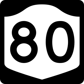
New York State Route 80 (NY 80) is a 127.32-mile-long (204.90 km) west–east New York State Route located within Onondaga, Madison, Chenango, Otsego, Herkimer, and Montgomery counties in New York. Its western terminus is located at a junction with NY 175 in the city of Syracuse in Onondaga County, from which it actually runs in a north–south direction for 20 miles (32 km). The eastern terminus is located at a junction with NY 5 in the village of Nelliston in Montgomery County. The route is signed north–south from U.S. Route 20 (US 20) north to NY 5.

County Route 18 (CR 18) is a county-maintained highway in western Otsego County, New York, in the United States. It extends for 34.83 miles (56.05 km) from an intersection with New York State Route 51 (NY 51) in the town of Butternuts to the Oneida County line at Plainfield, where it becomes CR 2. The highway runs along the eastern bank of the Unadilla River and parallels NY 8, which follows the western bank of the river. CR 18 enters the vicinity of several villages and hamlets, including the village of New Berlin and the hamlet of Unadilla Forks.
Edmeston is a census-designated place (CDP) forming the central settlement of the town of Edmeston in Otsego County, New York, United States. The population of the CDP was 657 at the 2010 census.


