Earlville, New York

Last updated
Earlville, New York
Earlville Opera House May 09.jpg
Earlville Opera House
Colchester (Village); Hubbardsville (Village); Earlville Business Notices.; Earlville (Village) NYPL1584256.tiff
Earlville in 1875
USA New York location map.svg
Red pog.svg
Earlville
Location within the state of New York
Coordinates: 42°44′28″N75°32′38″W / 42.74111°N 75.54389°W / 42.74111; -75.54389
Country United States
State New York
Counties Madison, Chenango
Towns Hamilton, Sherburne
Area
[1]
  Total1.08 sq mi (2.80 km2)
  Land1.08 sq mi (2.80 km2)
  Water0.00 sq mi (0.00 km2)
Elevation
1,099 ft (335 m)
Population
 (2020)
  Total774
  Density716.00/sq mi (276.49/km2)
Time zone UTC-5 (Eastern (EST))
  Summer (DST) UTC-4 (EDT)
ZIP code
13332
Area code 315
FIPS code 36-21523
GNIS feature ID0948958
Website www.villageofearlville.com

Earlville is a village in New York state bisected by two counties: Madison County and Chenango County, United States. The population was 774 as per the 2020 Decennial census, [2] a decrease from the 872 reported in the 2010 census. [3] The village is named after Jonas Earl, a canal commissioner. [4]

Contents

The village of Earlville is at the intersection of four towns: Sherburne, Hamilton, Lebanon, and Smyrna. The east–west thoroughfare, East and West Main streets, runs along the county line. The Madison County part of Earlville is part of the Syracuse Metropolitan Statistical Area.

History

The area was first settled around 1792 and was originally called "Forks" or "Madison Forks" [5] until the current name was adopted around 1835, after development of the Chenango Canal. It was named for the builder of the Chenango Canal. After canal transportation waned, railroad service helped community commerce.

Earlville became an incorporated village in 1887. The Earlville Historic District was added to the National Register of Historic Places in 1982. [6] The Earlville Opera House was listed in 1973 and houses a theater, two art galleries, an arts cafe, and an artisan gift shop. [6]

Geography

Earlville is located at 42°44′28″N75°32′38″W / 42.74111°N 75.54389°W / 42.74111; -75.54389 (42.741079, -75.543827), [7] positioned between the Chenango River to the west and the Sangerfield River, a tributary of the Chenango River, to the east. The Chenango River is a southward-flowing tributary of the Susquehanna River.

According to the United States Census Bureau, the village has a total area of 1.1 square miles (2.8 km2), all land. [3]

New York State Route 12B, a north–south highway, passes through the center of the village as North and South Main streets. East and West Main streets cross NY 12B, dividing the village between the two counties (Madison and Chenango).

Demographics

Historical population
CensusPop.Note
1870 399
1880 293−26.6%
1890 53682.9%
1900 71132.6%
1910 87422.9%
1920 792−9.4%
1930 8689.6%
1940 864−0.5%
1950 9459.4%
1960 1,0046.2%
1970 1,0504.6%
1980 985−6.2%
1990 883−10.4%
2000 791−10.4%
2010 87210.2%
2020 774−11.2%
U.S. Decennial Census [8]

As of the census [9] of 2000, there were 791 people, 298 households, and 219 families residing in the village. The population density was 729.4 inhabitants per square mile (281.6/km2). There were 329 housing units at an average density of 303.4 per square mile (117.1/km2). The racial makeup of the village was 98.99% White, 0.25% Asian, and 0.76% from two or more races. Hispanic or Latino of any race were 0.76% of the population.

There were 298 households, out of which 36.2% had children under the age of 18 living with them, 55.4% were married couples living together, 13.8% had a female householder with no husband present, and 26.2% were non-families. 20.5% of all households were made up of individuals, and 8.4% had someone living alone who was 65 years of age or older. The average household size was 2.65 and the average family size was 3.03.

In the village, the population was spread out, with 27.2% under the age of 18, 7.3% from 18 to 24, 27.7% from 25 to 44, 24.4% from 45 to 64, and 13.4% who were 65 years of age or older. The median age was 38 years. For every 100 females, there were 87.9 males. For every 100 females age 18 and over, there were 87.0 males.

The median income for a household in the village was $32,500, and the median income for a family was $33,654. Males had a median income of $27,381 versus $24,038 for females. The per capita income for the village was $15,383. About 9.0% of families and 11.8% of the population were below the poverty line, including 15.6% of those under age 18 and 10.7% of those age 65 or over.

Earlville homes

Earlville is known for its lovely historical Victorian homes and Second Empire mansard roofs. Homes often have traditionally vibrant colors popular for "painted ladies" of the era.

Related Research Articles

<span class="mw-page-title-main">Chenango County, New York</span> County in New York, United States

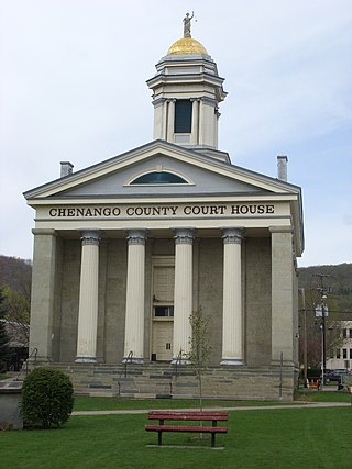
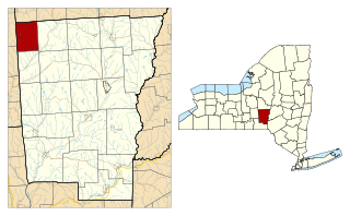
Chenango County is a county located in the south-central section U.S. state of New York. As of the 2020 census, the population was 47,220. Its county seat is Norwich. The county's name originates from an Oneida word meaning 'large bull-thistle'.

<span class="mw-page-title-main">Dickinson, Broome County, New York</span> Town in New York, United States

Dickinson is a town in Broome County, New York, United States. The population was 5,083 at the 2020 census. The town was named after Daniel S. Dickinson.

<span class="mw-page-title-main">Fenton, New York</span> Town in New York, United States

Fenton is a town in Broome County, New York, United States. The population was 6,441 at the 2020 census. The town was named after Reuben Fenton, a governor of New York.

<span class="mw-page-title-main">Port Dickinson, New York</span> Village in New York, United States

Port Dickinson is a village in Broome County, New York, United States. The population was 1,641 at the 2010 census. It is part of the Binghamton Metropolitan Statistical Area.

<span class="mw-page-title-main">North Norwich, New York</span> Town in New York, United States

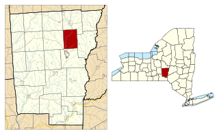
North Norwich is a town in Chenango County, New York, United States. The population was 1,783 at the 2010 census. The town is directly north of the City of Norwich in the eastern half of the county.

Afton is a village in Chenango County, New York, United States. The population was 822 at the 2010 census. The village is named after the poem "Sweet Afton" by Scottish poet Robert Burns, referring to the River Afton in Ayrshire, Scotland.

<span class="mw-page-title-main">Bainbridge (village), New York</span> Village in New York, United States

Bainbridge is a village in Chenango County, New York, United States. The population was 1,355 at the 2010 census. The village is at the center of the town of Bainbridge and lies between Binghamton and Oneonta.

<span class="mw-page-title-main">Greene (village), New York</span> Village in New York, United States

Greene is a village in Chenango County, New York, United States. The population was 1,580 at the 2010 census. The village is named after General Nathanael Greene. It is within the town of Greene and is northeast of Binghamton.

<span class="mw-page-title-main">Greene, New York</span> Town in New York, United States

Greene is a town in Chenango County, New York, United States. The population was 5,604 at the 2010 census. The town is named after General Nathanael Greene. It is located in the southwestern corner of the county and contains a village, also named Greene. The town and village are northeast of Binghamton. Greene was founded in 1792, but commenced in 1798.

New Berlin is a village in Chenango County, New York, United States. The population was 1,028 at the 2010 census. The village is by the eastern town line of the town of New Berlin and is northeast of Norwich.

<span class="mw-page-title-main">Oxford (village), New York</span> Village in New York, United States

Oxford is a village in Chenango County, New York, United States. The population was 1,450 at the 2010 census. The village is named after Oxford, Massachusetts, the hometown of the landowner.

<span class="mw-page-title-main">Oxford, New York</span> Town in New York, United States

Oxford is a town in Chenango County, New York, United States. The town contains a village also named Oxford. Oxford is an interior town in the south-central part of the county, southwest of the city of Norwich. At the 2010 census the town population was 3,901. The name derives from that of the native town of an early landowner from New England.

<span class="mw-page-title-main">Sherburne (village), New York</span> Village in New York, United States

Sherburne is a village in Chenango County, New York, United States. The population was 1,367 at the 2010 census. It is in the town of Sherburne, north of Norwich.
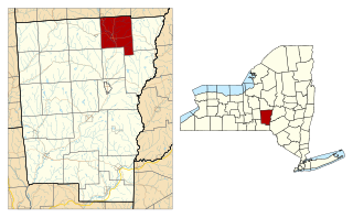
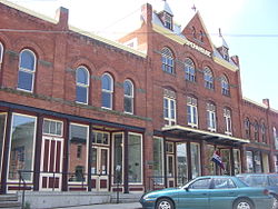
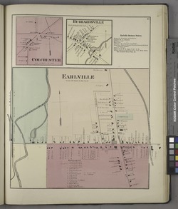
Smyrna is a village in Chenango County, New York, United States. The population was 213 at the 2010 census. The village is located in the town of Smyrna and is near the northern border of Chenango County.

<span class="mw-page-title-main">Smyrna, New York</span> Town in New York, United States

Smyrna is a town in Chenango County, New York, United States. The population was 1,280 at the 2010 census. Smyrna is named after a coastal city in ancient Greece, nowadays modern Izmir in Turkey.

<span class="mw-page-title-main">DeRuyter (village), New York</span> Village in New York, United States

DeRuyter is a village located in the Town of DeRuyter in Madison County, New York, United States. The population was 558 at the 2010 census. The village and town are named after Michiel Adriaenszoon de Ruyter, a famous admiral in the Dutch navy.

<span class="mw-page-title-main">Hamilton (village), New York</span> Village in Madison County, New York, US

The Village of Hamilton is a village located within the town of Hamilton in Madison County, New York, United States. Notably, it is the location of Colgate University and has a population of 4,239, according to the 2010 census. The 2017 movie Pottersville starring Michael Shannon and Judy Greer was filmed here.

Hamilton is a town in Madison County, New York, United States. The population was 6,690 at the 2010 census. The town is named after American Founding Father Alexander Hamilton.

Madison is a village in Madison County, New York, United States. The population was 305 at the 2010 census. The village and its town are named after President James Madison.

<span class="mw-page-title-main">Madison, New York</span> Town in New York, United States

Madison is a town in Madison County, New York, United States. The population was 3,008 at the 2010 census.

References

  1. "ArcGIS REST Services Directory". United States Census Bureau. Retrieved September 20, 2022.
  2. "U.S. Census Bureau" . Retrieved February 4, 2023.
  3. 1 2 "Geographic Identifiers: 2010 Demographic Profile Data (G001): Earlville village, New York". U.S. Census Bureau, American Factfinder. Archived from the original on February 12, 2020. Retrieved November 26, 2014.
  4. Gannett, Henry (1905). The Origin of Certain Place Names in the United States. Govt. Print. Off. pp.  112.
  5. "Official Town of Hamilton website" . Retrieved February 4, 2023.
  6. 1 2 "National Register Information System". National Register of Historic Places . National Park Service. March 13, 2009.
  7. "US Gazetteer files: 2010, 2000, and 1990". United States Census Bureau. 2011-02-12. Retrieved 2011-04-23.
  8. "Census of Population and Housing". Census.gov. Retrieved June 4, 2015.
  9. "U.S. Census website". United States Census Bureau . Retrieved 2008-01-31.