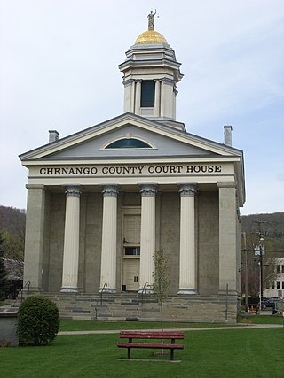
Chenango County is a county located in the south-central section of the U.S. state of New York. As of the 2020 census, the population was 47,220. Its county seat is Norwich. The county's name originates from an Oneida word meaning 'large bull-thistle'. The county is part of the Southern Tier region of the state.

Madison County is a county located in the U.S. state of New York. As of the 2020 census, the population was 68,016. Its county seat is Wampsville. The county is named after James Madison, the fourth president of the United States, and was first formed in 1806. The county is part of the Central New York region of the state.

Columbus is a town in Chenango County, New York, United States. The population was 975 at the 2010 census. Columbus is in the northeastern corner of the county and is northeast of Norwich.
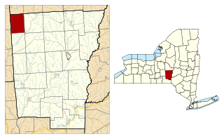
Lincklaen is a town in Chenango County, New York, United States. The population was 392 at the 2020 census. The town was named after Colonel John Lincklaen, an agent of the Holland Land Company and a land owner. The town is in the northwestern corner of the county, northwest of the city Norwich and northeast of Cortland.
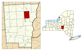
North Norwich is a town in Chenango County, New York, United States. The population was 1,783 at the 2010 census. The town is directly north of the City of Norwich in the eastern half of the county.

Pharsalia is a town in Chenango County, New York, United States. The population was 593 at the 2010 census. The town was named after Pharsalia, which is a commonly accepted name of the decisive battle in the Great Roman Civil War, where Julius Caesar defeated Pompey in 48 BCE.

Preston is a town in Chenango County, New York, United States. The population was 1,044 at the 2010 census. Preston is an interior town of Chenango County and is west of the city of Norwich.
Eaton is a town in Madison County, New York, United States. The population was 4,284 at the 2020 census, down from 5,255 in 2010.
Nelson is a town in Madison County, New York, United States. The population was 1,890 at the 2020 census. The town was named after Horatio Nelson, the English naval hero.
Smithfield is a town in Madison County, New York, United States. Administrative offices are in the hamlet of Peterboro. The town is named after Peter Smith, an original land owner. As of the 2020 census, the population was 1,127, down from 1,288 in 2010.

Sangerfield is a town in Oneida County, New York, United States. The population was 2,561 at the 2010 census. The town is named after Jedediah Sanger, an early settler.

Earlville is a village in New York state bisected by two counties: Madison County and Chenango County, United States. The population was 774 as per the 2020 decennial census, a decrease from the 872 reported in the 2010 census. The village is named after Jonas Earl, a canal commissioner.

Greene is a village in Chenango County, New York, United States. The population was 1,580 as of the 2010 census. The village is named after General Nathanael Greene. It is within the town of Greene and is northeast of Binghamton.

Sherburne is a village in Chenango County, New York, United States. The population was 1,367 at the 2010 census. It is in the town of Sherburne, north of Norwich.
Smyrna is a village in Chenango County, New York, United States. The population was 213 at the 2010 census. The village is located in the town of Smyrna and is near the northern border of Chenango County.

Cazenovia is a village in the town of Cazenovia in Madison County, New York, United States. As of the 2020 census, the village had a population of 2,767. The village lies at the south end of Cazenovia Lake and is within a half hour of Syracuse. The village is located on US Route 20 and New York State Route 13, and was home to Cazenovia College.

DeRuyter is a village in the town of DeRuyter in Madison County, New York, United States. The population was 408 at the 2020 census, down from 558 in 2010. The village and town are named after Michiel Adriaenszoon de Ruyter, a famous admiral in the Dutch navy.
DeRuyter is a town in Madison County, New York, United States. The population was 1,276 at the 2020 census, down from 1,589 in 2010. The town is named after Michiel Adriaenszoon de Ruyter, a famous admiral in the Dutch navy. The name de Ruyter means "the Rider".

Madison is a village in Madison County, New York, United States. The population was 311 at the 2020 census. The village and its town are named after President James Madison.

Madison is a town in Madison County, New York, United States. The population was 2,766 at the 2020 census. The village of Madison is the largest community within the town. Madison, along with the rest of Madison County, is part of the Syracuse Metropolitan Area.