Stockbridge, New York

Last updated
Stockbridge, New York
USA New York location map.svg
Red pog.svg
Stockbridge, New York
Location within the state of New York
Coordinates: 42°59′N75°35′W / 42.983°N 75.583°W / 42.983; -75.583
Country United States
State New York
County Madison
Government
  Type Town Council
   Town Supervisor Alexander R. Stepanski (R)
   Town Council
Members' List
Area
[1]
  Total31.53 sq mi (81.66 km2)
  Land31.53 sq mi (81.66 km2)
  Water0.00 sq mi (0.00 km2)
Elevation
633 ft (193 m)
Population
 (2010)
  Total2,103
  Estimate 
(2016) [2]
2,021
  Density64.10/sq mi (24.75/km2)
Time zone UTC-5 (Eastern (EST))
  Summer (DST) UTC-4 (EDT)
ZIP code
13409
Area code 315
FIPS code 36-053-71399
GNIS feature ID0979527

Stockbridge is a town in Madison County, New York, United States. The population was 2,103 at the 2010 census. The name is derived from a group of Native Americans.

Contents

The Town of Stockbridge is located on the eastern border of the county.

History

The land surrounding where Stockbridge would be established, was being lived upon by "Stockbridge Indians" (as local settlers would refer to them), who had been relocated already to the New Stockbridge Indian Territory during the latter half the 18th century, being told that this land was to be reserved for future tribal generations. The Stockbridge, refuges of tribes mainly of adjoining New York that had settled in the "prayer town" of Stockbridge, Massachusetts, [3] accepted an invitation of the Oneidas to live and share on their reservation in New York. Subsequent disagreements with White settlers caused many Stockbridge Indians to relocate to Indiana and later to Wisconsin, where they became the Stockbridge Munsee Band of Mohican Indians. Stockbridge is the birthplace of meatpacking industrialist Philip Danforth Armour and brother Herman Ossian Armour.

The town was first settled in 1791 by pioneers from New England. The town was formed in 1836 by composing parts of four other towns: Augusta, Lenox, Smithfield and Vernon.

Geography

The east town line is the border of Oneida County.

According to the United States Census Bureau, the town has a total area of 31.7 square miles (82 km2), all land.

Demographics

Historical population
CensusPop.Note
1840 2,320
1850 2,081−10.3%
1860 2,068−0.6%
1870 1,847−10.7%
1880 2,0239.5%
1890 1,845−8.8%
1900 1,622−12.1%
1910 1,485−8.4%
1920 1,413−4.8%
1930 1,369−3.1%
1940 1,258−8.1%
1950 1,53722.2%
1960 1,5742.4%
1970 1,7118.7%
1980 1,94713.8%
1990 1,9681.1%
2000 2,0805.7%
2010 2,1031.1%
2016 (est.)2,021 [2] −3.9%
U.S. Decennial Census [4]

As of the census [5] of 2000, there were 2,080 people, 739 households, and 571 families residing in the town. The population density was 65.7 inhabitants per square mile (25.4/km2). There were 802 housing units at an average density of 25.3 per square mile (9.8/km2). The racial makeup of the town was 96.63% White, 0.38% African American, 0.91% Native American, 0.29% Asian, 0.24% from other races, and 1.54% from two or more races. Hispanic or Latino of any race were 0.82% of the population.

There were 739 households, out of which 37.9% had children under the age of 18 living with them, 60.4% were married couples living together, 10.7% had a female householder with no husband present, and 22.6% were non-families. 17.9% of all households were made up of individuals, and 8.7% had someone living alone who was 65 years of age or older. The average household size was 2.81 and the average family size was 3.14.

In the town, the population was spread out, with 29.5% under the age of 18, 8.1% from 18 to 24, 29.6% from 25 to 44, 22.1% from 45 to 64, and 10.8% who were 65 years of age or older. The median age was 35 years. For every 100 females, there were 101.7 males. For every 100 females age 18 and over, there were 98.8 males.

The median income for a household in the town was $37,700, and the median income for a family was $41,250. Males had a median income of $30,701 versus $21,712 for females. The per capita income for the town was $15,856. About 9.9% of families and 12.9% of the population were below the poverty line, including 13.9% of those under age 18 and 12.3% of those age 65 or over.

Communities and locations in Stockbridge

Related Research Articles

<span class="mw-page-title-main">Schuyler, New York</span> Town in Herkimer County, New York, US

Schuyler is a town in Herkimer County, New York, United States. The population was 3,420 at the 2010 census. The town is in the western part of Herkimer County and is east of Utica.

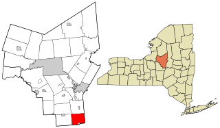
Lenox is a town in Madison County, New York, United States. The population was 9,112 as of the 2010 census.

<span class="mw-page-title-main">Munnsville, New York</span> Village in New York, United States

Munnsville is a village located in the Town of Stockbridge in Madison County, New York, United States. The population was 474 at the 2010 census. The village is named for an early settler, Asa Munn, and located on New York State Route 46.

<span class="mw-page-title-main">Augusta, New York</span> Town in New York, United States

Augusta is a town in Oneida County, New York, United States. The population was 2,020 at the 2010 census.

<span class="mw-page-title-main">Floyd, New York</span> Town in New York, United States

Floyd is a town in Oneida County, New York, United States. The population was 3,819 at the 2010 census. The town is named after William Floyd, a signer of the Declaration of Independence.

<span class="mw-page-title-main">Marshall, New York</span> Town in New York, United States

Marshall is a town in Oneida County, New York, United States. The population was 2,131 at the 2010 census.

<span class="mw-page-title-main">Paris, New York</span> Town in New York, United States

Paris is a town in Oneida County, New York, United States. The town is in the southeast part of the county and is south of Utica. The population was 4,411 at the 2010 census. The town was named after an early benefactor, Colonel Isaac Paris.

<span class="mw-page-title-main">Sangerfield, New York</span> Town in New York, United States

Sangerfield is a town in Oneida County, New York, United States. The population was 2,561 at the 2010 census. The town is named after Jedediah Sanger, an early settler.

<span class="mw-page-title-main">Steuben, New York</span> Town in Oneida County, New York, US

Steuben is a town in Oneida County, New York, United States. The population was 1,110 at the 2010 census. The town is named after Baron von Steuben, a Prussian general who fought on the American side in the American Revolutionary War.

<span class="mw-page-title-main">Vienna, New York</span> Town in New York, United States

Vienna is a town in Oneida County, New York, United States. The population was 5,440 at the 2010 census. The town is named after the capital of Austria.

<span class="mw-page-title-main">Westmoreland, New York</span> Town in New York, United States

Westmoreland is a town in Oneida County, New York, United States. The population was 6,138 at the 2010 census.

<span class="mw-page-title-main">Cicero, New York</span> Town in New York, United States

Cicero is a town in northern Onondaga County, New York, United States. As of the 2020 Census, the population was 31,435. The name of the town was assigned by a clerk interested in the classics, honoring Cicero, a Roman statesman.

<span class="mw-page-title-main">Hastings, New York</span> Town in New York, United States

Hastings is a town in Oswego County, New York, United States. Its population was 9,450 at the 2010 census. It is named after Hastings Curtiss, a prominent citizen and member of the State Assembly in 1824.

<span class="mw-page-title-main">West Monroe, New York</span> Town in New York, United States

West Monroe is a town in Oswego County, New York, United States. The population was 4,252 at the 2010 census.

<span class="mw-page-title-main">Plainfield, New York</span> Town in New York, United States

Plainfield is a town in Otsego County, New York, United States. The population was 915 at the 2010 census.

Bridgeport is a hamlet located partly in the town of Sullivan in Madison County, New York, United States and partly in the town of Cicero in Onondaga County. The population was 1,490 at the 2010 census.

<span class="mw-page-title-main">Oneida, Wisconsin</span> Unincorporated community in Wisconsin, United States

Oneida is an unincorporated community and former census-designated place (CDP) in the Town of Oneida, Outagamie County, Wisconsin, United States. The population was 1,070 at the 2000 census. At the census, part of the CDP lay within the Town of Hobart, which has since incorporated as a village, in adjacent Brown County. Oneida is located on Wisconsin Highway 54.

<span class="mw-page-title-main">Bridgewater, New York</span> Town in New York, United States

Bridgewater is a town in Oneida County, New York, United States. The population was 1,522 at the 2010 census.

<span class="mw-page-title-main">Vernon, New York</span> Town in New York, United States

Vernon is a town in Oneida County, New York, United States. The population was 5,408 at the 2010 census.

<span class="mw-page-title-main">Constantia (town), New York</span> Town in New York, United States

Constantia is a town in Oswego County, New York, United States. The population was 4,973 at the 2010 census.

References

  1. "2016 U.S. Gazetteer Files". United States Census Bureau. Retrieved Jul 5, 2017.
  2. 1 2 "Population and Housing Unit Estimates" . Retrieved June 9, 2017.
  3. Sultzman, Lee (1997). "Wappinger History" . Retrieved 14 January 2012.
  4. "Census of Population and Housing". Census.gov. Retrieved June 4, 2015.
  5. "U.S. Census website". United States Census Bureau . Retrieved 2008-01-31.

42°59′N75°35′W / 42.983°N 75.583°W / 42.983; -75.583