Oneida Creek

Last updated
Oneida Creek
Oneida Creek upstream of Swallow Bridge Road.JPG
Oneida Creek upstream of Swallow Bridge Road
USA New York relief location map.svg
Red pog.svg
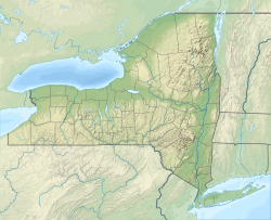
Location of the mouth of Oneida Creek in New York State
Usa edcp relief location map.png
Red pog.svg
Oneida Creek (the United States)
Location
Country United States
State New York
Counties Madison, Oneida
Cities Oneida, Sherrill
Physical characteristics
Source 
  location Town of Smithfield, Madison County
  coordinates 42°59′01″N75°40′46″W / 42.98361°N 75.67944°W / 42.98361; -75.67944 [1]
Mouth Oneida Lake
  location
South Bay, Town of Lenox, Madison/Oneida county border
  coordinates
43°09′52″N75°44′17″W / 43.16444°N 75.73806°W / 43.16444; -75.73806 [1]
Discharge 
  location Oneida [2]
  average175 cu ft/s (5.0 m3/s) [2]
  minimum9.5 cu ft/s (0.27 m3/s)
(September 6, 1999) [2]
  maximum11,400 cu ft/s (320 m3/s)
(June 28, 2013) [2]
Basin features
Waterfalls Stockbridge Falls

Oneida Creek is a small river in New York in the United States. [1] The creek enters the southeastern corner of Oneida Lake at a location known as South Bay, a bay of the lake. The name is derived from the Oneida tribe of the Iroquois. Stockbridge Falls is located on Oneida Creek.
Contents

Course

Oneida Creek rises in the Town of Smithfield. [1] The cities of Oneida and Sherrill are located along the lower part of the creek. The creek forms part of the boundary between Madison and Oneida counties before entering Oneida Lake near the community of South Bay in the Town of Lenox, located just south of the mouth of the creek. Verona Beach State Park is located north of the mouth.

Hydrology

The flow of the creek near the City of Oneida averages about 175 cu ft/s (5.0 m3/s). [2]

History

The region of the river is known for the historic Oneida Community of the 19th century. In the past the Erie Canal was closely associated with the creek prior to the canal being moved farther north.

See also

Related Research Articles

<span class="mw-page-title-main">Susquehanna River</span> Major river in the Northeastern United States

The Susquehanna River is a major river located in the Mid-Atlantic region of the United States, overlapping between the lower Northeast. At 444 miles (715 km) long, it is the longest river on the East Coast of the United States. By watershed area, it is the 16th-largest river in the United States, and also the longest river in the early 21st-century continental United States without commercial boat traffic.

<span class="mw-page-title-main">Mohawk River</span> River in the U.S. state of New York

The Mohawk River is a 149-mile-long (240 km) river in the U.S. state of New York. It is the largest tributary of the Hudson River. The Mohawk flows into the Hudson in Cohoes, New York, a few miles north of the city of Albany. The river is named for the Mohawk Nation of the Iroquois Confederacy. It is a major waterway in north-central New York. In the early 19th century, the river's east-west valley provided the setting and water for development of the Erie Canal, as a key to developing New York. The largest tributary, the Schoharie Creek, accounts for over one quarter (26.83%) of the Mohawk River's watershed. Another main tributary is the West Canada Creek, which makes up for 16.33% of the Mohawk's watershed.

<span class="mw-page-title-main">Chenango River</span> River in New York, United States

The Chenango River is a 90-mile-long (140 km) tributary of the Susquehanna River in central New York in the United States. It drains a dissected plateau area in upstate New York at the northern end of the Susquehanna watershed.

<span class="mw-page-title-main">Tualatin River</span> River in Oregon, United States

The Tualatin River is a tributary of the Willamette River in Oregon in the United States. The river is about 83 miles (134 km) long, and it drains a fertile farming region called the Tualatin Valley southwest and west of Portland at the northwest corner of the Willamette Valley. There are approximately 500,000 people residing on 15 percent of the land in the river's watershed.

<span class="mw-page-title-main">Salt River (Arizona)</span> River in Gila and Maricopa counties in Arizona, United States

The Salt River is a river in Gila and Maricopa counties in Arizona, United States, that is the largest tributary of the Gila River. The river is about 200 miles (320 km) long. Its drainage basin is about 13,700 square miles (35,000 km2) large. The longest of the Salt River's many tributaries is the 195-mile (314 km) Verde River. The Salt's headwaters tributaries, the Black River and East Fork, increase the river's total length to about 300 miles (480 km). The name Salt River comes from the fact that the river flows over large salt deposits shortly after the merging of the White and Black Rivers.

<span class="mw-page-title-main">Oneida Lake</span> Lake in New York state

Oneida Lake is the largest lake entirely within New York state, with a surface area of 79.8 square miles (207 km2). The lake is located northeast of Syracuse and near the Great Lakes. It feeds the Oneida River, a tributary of the Oswego River, which flows into Lake Ontario. From the earliest times until the opening of the Erie Canal in 1825, the lake was part of an important waterway connecting the Atlantic seaboard of North America to the continental interior.

<span class="mw-page-title-main">Otsego Lake (New York)</span> Lake in Otsego County, New York, USA

Otsego Lake is a 4,046-acre (16.37 km2) lake located in Otsego County in the U.S. state of New York. It is the source of the Susquehanna River and largest lake in Otsego County. The Village of Cooperstown is located at the lake's southern end. Glimmerglass State Park is located on the lake's northeastern shore, and includes Hyde Hall, a large mansion constructed in 1817, that overlooks the lake. The Glimmerglass Opera, opened in June 1987, is located on the western shore.

<span class="mw-page-title-main">Alsea River</span> River in Oregon, United States of America

The Alsea River flows 48.5 miles (78.1 km) from Alsea, an unincorporated community in the coastal mountains of the U.S. state of Oregon, to the Pacific Ocean near the city of Waldport. It begins at the confluence of the North Fork Alsea River and the South Fork Alsea River and ends in Alsea Bay, a wide estuary at Waldport. The river flows generally west-northwest in a winding course through the mountains of southern Benton and Lincoln counties, passing near the unincorporated community of Tidewater and through the Siuslaw National Forest. Its drainage basin extends into Lane County, along the headwaters of the South Fork Alsea River.

<span class="mw-page-title-main">Kern River</span> Wild And Scenic River in California, United States

The Kern River, previously Rio de San Felipe, later La Porciuncula, is an Endangered, Wild and Scenic river in the U.S. state of California, approximately 165 miles (270 km) long. It drains an area of the southern Sierra Nevada mountains northeast of Bakersfield. Fed by snowmelt near Mount Whitney, the river passes through scenic canyons in the mountains and is a popular destination for whitewater rafting and kayaking. It is the southernmost major river system in the Sierra Nevada, and is the only major river in the Sierra that drains in a southerly direction.

<span class="mw-page-title-main">Feather River</span> River in California, United States

The Feather River is the principal tributary of the Sacramento River, in the Sacramento Valley of Northern California. The river's main stem is about 73 miles (117 km) long. Its length to its most distant headwater tributary is just over 210 miles (340 km). The main stem Feather River begins in Lake Oroville, where its four long tributary forks join—the South Fork, Middle Fork, North Fork, and West Branch Feather Rivers. These and other tributaries drain part of the northern Sierra Nevada, and the extreme southern Cascades, as well as a small portion of the Sacramento Valley. The total drainage basin is about 6,200 square miles (16,000 km2), with approximately 3,604 square miles (9,330 km2) above Lake Oroville.

<span class="mw-page-title-main">Oswego River (New York)</span> River in upstate New York in the United States

The Oswego River is a river in upstate New York in the United States. It is the second-largest river flowing into Lake Ontario. James Fenimore Cooper’s novel The Pathfinder, or The Inland Sea is set in the Oswego River valley.

<span class="mw-page-title-main">Skokomish River</span> River in the United States

The Skokomish River is a river in Mason County, Washington, United States. It is the largest river flowing into Hood Canal, a western arm of Puget Sound. From its source at the confluence of the North and South Forks the main stem Skokomish River is approximately 9 miles (14 km) long. The longer South Fork Skokomish River is 40 miles (64 km), making the length of the whole river via its longest tributary about 49 miles (79 km). The North Fork Skokomish River is approximately 34 miles (55 km) long. A significant part of the Skokomish River's watershed is within Olympic National Forest and Olympic National Park.

<span class="mw-page-title-main">Canadarago Lake</span> Lake in Otsego County, New York, U.S.

Canadarago Lake is a 1,917-acre (7.76 km2) lake located in Otsego County, New York and is the source of Oaks Creek. The Village of Richfield Springs is located at the lake's northern end. It is the second largest lake in Otsego County, lying to the west of and parallel to the larger Otsego Lake. The lake's name is also spelled "Candajarago Lake" or "Caniadaraga Lake".

<span class="mw-page-title-main">Oriskany Creek</span> River in New York, United States

Oriskany Creek is a 33-mile-long (53 km) river in New York, United States. It rises in Madison County and flows northeastward, primarily through Oneida County. Oriskany Creek is a tributary of the Mohawk River and therefore part of the Hudson River watershed.

<span class="mw-page-title-main">West Canada Creek</span> River in New York, United States

The West Canada Creek is a 76-mile-long (122 km) river in upstate New York, United States. West Canada Creek is an important water way in Hamilton, Oneida, and Herkimer counties, draining the south part of the Adirondack Mountains before emptying into the Mohawk River near the Village of Herkimer. The name "Canada" is derived from an Iroquoian word for "village" (Kanata).

<span class="mw-page-title-main">Geography of New York (state)</span> State of the United States

The geography of New York (state) varies widely. Most of New York is dominated by farms, forests, rivers, mountains, and lakes. New York's Adirondack Park is larger than any U.S. National Park in the contiguous United States. Niagara Falls, on the Niagara River as it flows from Lake Erie to Lake Ontario, is a popular attraction. The Hudson River begins near Lake Tear of the Clouds and flows south through the eastern part of the state without draining lakes George or Champlain. Lake George empties at its north end into Lake Champlain, whose northern end extends into Canada, where it drains into the Richelieu River and then the St. Lawrence. Four of New York City's five boroughs are on the three islands at the mouth of the Hudson River: Manhattan Island, Staten Island, and Brooklyn and Queens on Long Island.

<span class="mw-page-title-main">Big Butte Creek</span> River in Oregon, United States of America

Big Butte Creek is a 12-mile-long (19 km) tributary of the Rogue River in the U.S. state of Oregon. It drains approximately 245 square miles (635 km2) of Jackson County. Its two forks, the North Fork and the South Fork, both begin high in the Cascade Range near Mount McLoughlin. Flowing predominantly west, they meet near the city of Butte Falls. The main stem flows generally northwest until it empties into the Rogue Falls was incorporated in 1911, and remains the only incorporated town within the watershed's boundaries.

Fish Creek is a moderately sized river emptying into the eastern end of Oneida Lake in Oneida County, New York. Formed by the confluence of its east and west forks near the hamlet of Blossvale, the creek flows southwest for 11 miles (18 km), through the towns of Annsville and Vienna. The last mile of the creek is channelized to form part of the Erie Canal, which joins the lake at Sylvan Beach. The creek drains approximately 528.9 square miles (1,370 km2) of the Tug Hill plateau country in Central New York.

<span class="mw-page-title-main">Butternut Creek (Limestone Creek tributary)</span> River in New York, United States

Butternut Creek is a stream in the greater Syracuse, New York area and a tributary of Limestone Creek, part of the Oneida Lake watershed. The creek is about 16 miles (26 km) long.

<span class="mw-page-title-main">Canajoharie Creek</span> Watercourse in the United States of America

The Canajoharie Creek is a river that flows into the Mohawk River in the Village of Canajoharie in the U.S. State of New York. The name "Canajoharie" is a Mohawk language term meaning "the pot that washes itself", referring to the "Canajoharie Boiling Pot", a 20-foot (6.1 m) wide and 10-foot (3.0 m) deep pothole in the Canajoharie Creek, just south of the village of Canajoharie. Bowmans Creek is one main tributary that enters the creek east of the Hamlet of Sprout Brook. The other main tributary is Brimstone Creek which enters the creek north-northwest of the Village of Ames.

References

  1. 1 2 3 4 "Oneida Creek". Geographic Names Information System . United States Geological Survey, United States Department of the Interior . Retrieved August 15, 2016.
  2. 1 2 3 4 5 "04243500 Oneida Creek at Oneida, NY, Water Data Report 2013" (PDF). National Water Information System. United States Geological Survey. 1949–2013. Retrieved August 15, 2016.