Bainbridge (village), New York

Last updated

Bainbridge, New York
Bainbridge town common and gazebo, New York.jpg
Town common and gazebo
USA New York location map.svg
Red pog.svg
Bainbridge
Location within the state of New York
Coordinates: 42°17′41″N75°28′48″W / 42.29472°N 75.48000°W / 42.29472; -75.48000
Country United States
State New York
County Chenango
Town Bainbridge
Area
[1]
  Total1.35 sq mi (3.51 km2)
  Land1.31 sq mi (3.40 km2)
  Water0.04 sq mi (0.10 km2)
Elevation
994 ft (303 m)
Population
 (2020)
  Total1,251
  Density952.05/sq mi (367.55/km2)
Time zone UTC-5 (Eastern (EST))
  Summer (DST) UTC-4 (EDT)
ZIP code
13733
Area code 607
FIPS code 36-04033
GNIS feature ID0942805
Website www.villageofbainbridgeny.org

Bainbridge is a village in Chenango County, New York, United States. The population was 1,355 at the 2010 census. [2] The village is at the center of the town of Bainbridge and lies between Binghamton and Oneonta.

Contents

History

The first settlement of the village site took place circa 1789. The village was incorporated in 1821. It was once the home for production of Elmer's Glue. In 1982, many of its historic buildings were included in the Bainbridge Historic District on the National Register of Historic Places. [3] The Charles C. Hovey House and Strong Leather Company Mill was listed in 1996. [3]

In June 2006, a weather system stalled over most of the Southern Tier in New York state, causing river levels to rise dramatically. The Susquehanna River, which runs through the eastern part of the village of Bainbridge, rose to 27 feet (8.2 m), which was 14 feet (4.3 m) over the river's flood stage. Major flooding took place in the village, including the northern parts of North Main Street and the area near the town baseball field. The river stretched far up East Main Street, passing the village garage and post office. Flood waters also reached the exit and entrance to the westbound side of Interstate 88.

Geography

Bainbridge is located in southeastern Chenango County at 42°17′41″N75°28′48″W / 42.29472°N 75.48000°W / 42.29472; -75.48000 (42.294803, -75.480089). [4]

According to the United States Census Bureau, the village has a total area of 1.3 square miles (3.3 km2), of which 1.2 square miles (3.2 km2) is land and 0.04 square miles (0.1 km2), or 2.74%, is water. [2]

The village is adjacent to the Susquehanna River and Interstate 88 (exit 8). NY-7 (North and South Main Street) and NY-206 (East and West Main Street) intersect at the village.

Demographics

Historical population
CensusPop.Note
1840 500
1860 320
1870 681112.8%
1880 78114.7%
1890 1,04934.3%
1900 1,0924.1%
1910 1,1596.1%
1920 1,2598.6%
1930 1,3245.2%
1940 1,4509.5%
1950 1,5053.8%
1960 1,71213.8%
1970 1,674−2.2%
1980 1,603−4.2%
1990 1,550−3.3%
2000 1,365−11.9%
2010 1,355−0.7%
2020 1,251−7.7%
U.S. Decennial Census [5]

As of the census [6] of 2000, there were 1,365 people, 578 households, and 354 families residing in the village. The population density was 1,064.3 inhabitants per square mile (410.9/km2). There were 650 housing units at an average density of 506.8 per square mile (195.7/km2). The racial makeup of the village was 98.17% White, 0.22% Black or African American, 0.37% Asian, 0.15% Pacific Islander, 0.29% from other races, and 0.81% from two or more races. Hispanic or Latino of any race were 1.17% of the population.

There were 578 households, out of which 31.0% had children under the age of 18 living with them, 47.6% were married couples living together, 10.2% had a female householder with no husband present, and 38.6% were non-families. 32.7% of all households were made up of individuals, and 13.1% had someone living alone who was 65 years of age or older. The average household size was 2.35 and the average family size was 2.99.

In the village, the population was spread out, with 26.4% under the age of 18, 8.8% from 18 to 24, 26.2% from 25 to 44, 23.5% from 45 to 64, and 15.1% who were 65 years of age or older. The median age was 38 years. For every 100 females, there were 94.7 males. For every 100 females age 18 and over, there were 89.3 males.

The median income for a household in the village was $35,231, and the median income for a family was $40,962. Males had a median income of $28,583 versus $24,091 for females. The per capita income for the village was $18,666. About 7.8% of families and 12.0% of the population were below the poverty line, including 15.2% of those under age 18 and 10.2% of those age 65 or over.

Economy

The village of Bainbridge is small. Its proximity to other villages and towns, such as Oxford, Guilford, Afton, and Unadilla, and to the small cities of Sidney and Norwich, help to expand business and employment opportunities. In addition, its location on New York State Route 7 and on Interstate 88, between the regionally-important cities of Albany and Binghamton, also helps to inject a degree of stimulus into the local economy.

The village has a 7-acre (28,000 m2) industrial park called the Bainbridge Business park. The park is broken up into seven lots, each 1-acre (4,000 m2). An outpatient clinic for the Veterans Health Administration is among the occupants. The old Elmer's Glue plant was once a foundation of the local economy, but in its absence other businesses have had to fill the vacuum. Bainbridge is home to the executive headquarters of Conklin Fashions, one of the largest wholesale suppliers of costume jewelry and fashion accessories in the United States and an employer of several dozen local citizens.

Related Research Articles

<span class="mw-page-title-main">Chenango, New York</span> Town in New York, United States

Chenango is a town in Broome County, New York, United States. The population was 10,983 at the 2020 census.

<span class="mw-page-title-main">Johnson City, New York</span> Village in New York, United States

Johnson City is a village in Broome County, New York, United States. The population was 15,343 at the 2020 census. It is part of the Binghamton Metropolitan Statistical Area.

<span class="mw-page-title-main">Kirkwood, New York</span> Town in New York, United States

Kirkwood is a town in Broome County, New York, United States. The population was 5,495 at the 2020 census. The town is named after James P. Kirkwood, who was an engineer responsible for constructing the local railroad.

<span class="mw-page-title-main">Port Dickinson, New York</span> Village in New York, United States

Port Dickinson is a village in Broome County, New York, United States. The population was 1,641 at the 2010 census. It is part of the Binghamton Metropolitan Statistical Area.

<span class="mw-page-title-main">Triangle, New York</span> Town in New York, United States

Triangle is a town in Broome County, New York, United States. The population was 2,946 at the 2010 census. The town's primary settlement is the village of Whitney Point.

<span class="mw-page-title-main">Union, New York</span> Town in New York, United States

Union is a town in Broome County, New York, United States. As of the 2010 census, the town had a total population of 56,346. The name derives from the town having served as a rendezvous for the Sullivan Expedition.

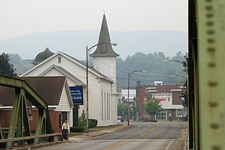
Masonville is a town in Delaware County, New York, United States. The population was 1,320 at the 2010 census. The town is in the western part of the county.

<span class="mw-page-title-main">Earlville, New York</span> Village in New York, United States

Earlville is a village in New York state bisected by two counties: Madison County and Chenango County, United States. The population was 774 as per the 2020 Decennial census, a decrease from the 872 reported in the 2010 census. The village is named after Jonas Earl, a canal commissioner.

Afton is a village in Chenango County, New York, United States. The population was 822 at the 2010 census. The village is named after the poem "Sweet Afton" by Scottish poet Robert Burns, referring to the River Afton in Ayrshire, Scotland.

<span class="mw-page-title-main">Afton, New York</span> Town in New York, United States

Afton is a town in Chenango County, New York, United States. The population was 2,769 at the 2020 census. Afton is situated in the southeast corner of the county and lies wholly within the original Township of Clinton. It was formed from the town of Bainbridge on November 18, 1857, and derives its name from Afton Water, a small river in the parish of New Cumnock, Ayrshire, Scotland, immortalized by the poet Robert Burns. It is bounded on the north by Bainbridge and Coventry, on the east by Delaware County, and on the west and south by Broome County.

<span class="mw-page-title-main">Bainbridge, New York</span> Town in New York, United States

Bainbridge is a town in Chenango County, New York, United States. The population was 3,308 at the 2010 census. The town is at the eastern border of Chenango County, halfway between Binghamton and Oneonta.

<span class="mw-page-title-main">Greene (village), New York</span> Village in New York, United States

Greene is a village in Chenango County, New York, United States. The population was 1,580 at the 2010 census. The village is named after General Nathanael Greene. It is within the town of Greene and is northeast of Binghamton.

<span class="mw-page-title-main">Greene, New York</span> Town in New York, United States

Greene is a town in Chenango County, New York, United States. The population was 5,604 at the 2010 census. The town is named after General Nathanael Greene. It is located in the southwestern corner of the county and contains a village, also named Greene. The town and village are northeast of Binghamton. Greene was founded in 1792, but commenced in 1798.

New Berlin is a village in Chenango County, New York, United States. The population was 1,028 at the 2010 census. The village is by the eastern town line of the town of New Berlin and is northeast of Norwich.

<span class="mw-page-title-main">Norwich (town), New York</span> Town in New York, United States

Norwich is a town in Chenango County, New York, United States. The population was 3,998 at the 2010 census.

<span class="mw-page-title-main">Norwich, New York</span> City in New York, United States

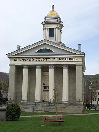
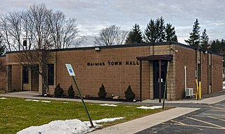
Norwich is a city and county seat of Chenango County, New York, United States. Surrounded on all sides by the Town of Norwich, the city's name is taken from Norwich, England. Its population was 7,051 at the 2020 census.

<span class="mw-page-title-main">Oxford (village), New York</span> Village in New York, United States

Oxford is a village in Chenango County, New York, United States. The population was 1,450 at the 2010 census. The village is named after Oxford, Massachusetts, the hometown of the landowner.

<span class="mw-page-title-main">Sherburne (village), New York</span> Village in New York, United States

Sherburne is a village in Chenango County, New York, United States. The population was 1,367 at the 2010 census. It is in the town of Sherburne, north of Norwich.

<span class="mw-page-title-main">Sidney (village), New York</span> Village in New York, United States

Sidney is a village in Delaware County, New York, United States. The population was 3,900 at the 2010 census. The village is in the western part of the town of Sidney.

<span class="mw-page-title-main">Unadilla, New York</span> Town in New York, United States

Unadilla is a town in Otsego County, New York, United States. As of the 2010 census, the town had a population of 4,392. The name is derived from an Iroquois word for "meeting place". Unadilla is located in the southwestern corner of the county, southwest of Oneonta. The village of Unadilla is located in the southern part of the town. The mayor of Unadilla is Jason Cotten.

References

  1. "ArcGIS REST Services Directory". United States Census Bureau. Retrieved September 20, 2022.
  2. 1 2 "Geographic Identifiers: 2010 Demographic Profile Data (G001): Bainbridge village, New York". U.S. Census Bureau, American Factfinder. Archived from the original on February 12, 2020. Retrieved November 26, 2014.
  3. 1 2 "National Register Information System". National Register of Historic Places . National Park Service. March 13, 2009.
  4. "US Gazetteer files: 2010, 2000, and 1990". United States Census Bureau. February 12, 2011. Retrieved April 23, 2011.
  5. "Census of Population and Housing". Census.gov. Retrieved June 4, 2015.
  6. "U.S. Census website". United States Census Bureau . Retrieved January 31, 2008.