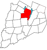
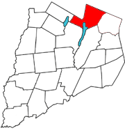
Otsego is a town in the north-central part of Otsego County, New York, United States. The population was 3,900 at the 2010 census. The town is named after Lake Otsego, which forms part of the town's eastern border.
Springfield is a town in Otsego County, New York, United States. The population was 1,358 at the 2010 census.
Schuyler Lake is the name of a small hamlet in the town of Exeter in Otsego County, New York, United States. It lies at the south end of Canadarago Lake and south of Richfield Springs. It is also known as Kaniatarake, which is a Mohawk name that translates to "on the lake".
East Worcester is a hamlet and census-designated place (CDP) in the town of Worcester in Otsego County, New York, United States. It was first listed as a CDP prior to the 2020 census.
Garrattsville is a hamlet in Otsego County, New York, United States. It is located in the town of New Lisbon at the intersection of Otsego County Route 16 and New York State Route 51. Butternut Creek flows southwest through the hamlet.

Fly Creek is a non-incorporated hamlet three miles west of the Village of Cooperstown on conjoined NY-28/NY-80, in the Town of Otsego, in Otsego County, New York, United States. The zipcode is 13337. The Fly Creek Cider Mill and Orchard is located by the hamlet.
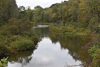
Oaks Creek is a river that drains Canadarago Lake, which is situated in the north central region of Otsego County, New York. The creek begins by the Hamlet of Schuyler Lake and flows southeast approximately 9.32 miles (15.00 km), dropping only 105 feet (32 m) in elevation, before converging with the Susquehanna River south of the Village of Cooperstown, by the Hamlet of Index. From the source to Oaksville the creek flows along Panther Mountain. Fly Creek is a main tributary, that converges with Oaks Creek south of the Hamlet of Fly Creek.
Fly Creek also known as Vlaie Creek, begins by the border of the Town of Otsego and Town of Springfield in Otsego County, New York. Fly Creek then travels south towards the hamlet of Fly Creek and converges with Oaks Creek south of the hamlet of Fly Creek. The Fly Creek Cider Mill and Orchard is located next to Fly Creek. The Mill gets power to make cider from the Fly Creek water flow and is the last remaining mill in the area. Fly Creek is also located partly within the Fly Creek Historic District.
Index is a hamlet in the Town of Hartwick, New York, and partially in Town of Otsego, Otsego County, New York, United States. It is located at the corner of CR-11 and NY-28. Oaks Creek runs east through the hamlet and converges with the Susquehanna River just east of the hamlet.
Toddsville is a hamlet located south of Fly Creek on the Oaks Creek in the Town of Otsego and Hartwick, Otsego County, New York, United States. Toddsville derived its name from Jehiel Todd, who came from Connecticut in an early day and settled in that locality. In 1790 the first mill in the town was opened in Toddsville.
Taylortown is located 3.5 miles (5.6 km) north of the Hamlet of Fly Creek on Otsego County Route 26 in Otsego County, New York, United States. Taylortown was founded by and named after the Taylor family, who moved there from Bennington, Vermont.
Lidell Creek is a small creek in the town of Exeter in Otsego County, New York. Lidell Creek flows into Oaks Creek by Lidell Corners, south of the Hamlet of Schuyler Lake.
Pail Shop Corners is a hamlet located at the corner of Hoke Road, Goose Street, and CR-26 north of Fly Creek in the Town of Otsego, in Otsego County, New York, United States. The Fly Creek Cider Mill and Orchard is located by Pail Shop Corners.

Rum Hill is a mountain located in Central New York Region of New York northwest of the Hamlet of Pierstown. Red House Hill is located southeast, Metcalf Hill is located south, Allen Lake and Mohegan Hill are located north-northwest and Otsego Lake is located east of Rum Hill.
Hooker Mountain is a 2,310-foot-tall (700 m) mountain in the Central New York region of New York. It is located in Otsego County northwest of the hamlet of Schenevus. In 1935, a 79-foot-6-inch-tall (24.23 m) fire tower was installed on the mountain by the Civilian Conservation Corps. The tower ceased operations at the end of 1970, and later sold and removed in 1975.
Pleasant Brook is a hamlet located south of Cherry Valley, at the corner of NY 165 and Middlefield Road in the Town of Roseboom in Otsego County, New York, United States. Pleasant Brook runs west through the hamlet.
Pierstown is a hamlet located on CR-28 north of Cooperstown and west of Five Mile Point in the Town of Otsego, in Otsego County, New York, United States.
South Hartwick is a hamlet in Otsego County, New York, United States. The community is located along Otsego County Route 11 which runs parallel with NY 205, 13 miles (21 km) north of Oneonta. South Hartwick is served by ZIP code 13348.
Welcome is a hamlet in Otsego County, New York, United States. It is located southeast of Garrattsville on Otsego County Route 16.
Westford is a census-designated place (CDP) and the primary hamlet in the town of Westford, Otsego County, New York, United States. It was first listed as a CDP prior to the 2020 census.


