
Otsego County is a county in the U.S. state of New York. As of the 2010 census, the population was 62,259. The county seat is Cooperstown. The name Otsego is from a Mohawk or Oneida word meaning "place of the rock."

Hampden County is a non-governmental county located in the Pioneer Valley of the state of Massachusetts, in the United States. As of the 2010 census, Hampden County's population was 463,490. As of 2019, Hampden County's estimated population was 466,372. Its traditional county seat is Springfield, the Connecticut River Valley's largest city, and economic and cultural capital; with an estimated population of 154,758, approximately 1 in 3 residents of Hampden County live in Springfield. Hampden County was split from Hampshire County in 1812, because Northampton, Massachusetts, was made Hampshire County's "shire town" in 1794; however, Springfield—theretofore Hampshire County's traditional shire town, dating back to its founding in 1636—grew at a pace far quicker than Northampton and was granted shire town-status over its own, southerly jurisdiction. It was named for parliamentarian John Hampden. To the north of Hampden County is modern-day Hampshire County; to the west is Berkshire County; to the east is Worcester County; to the south are Litchfield County, Hartford County, and Tolland County in Connecticut.

Springfield is a city in the state of Massachusetts, United States, and the seat of Hampden County. Springfield sits on the eastern bank of the Connecticut River near its confluence with three rivers: the western Westfield River, the eastern Chicopee River, and the eastern Mill River. As of the 2010 Census, the city's population was 153,060. As of 2019, the estimated population was 153,606, making it the third-largest city in Massachusetts, the fourth-most populous city in New England after Boston, Worcester, and Providence, and the 12th-most populous in the Northeastern United States. Metropolitan Springfield, as one of two metropolitan areas in Massachusetts, had a population of 692,942 as of 2010.

Springfield is a home rule-class city in and county seat of Washington County, Kentucky, United States. The population was 2,519 at the 2010 census.

Westfield is a city in Hampden County, in the Pioneer Valley of western Massachusetts, United States. Westfield was first settled in 1660. It is part of the Springfield, Massachusetts Metropolitan Statistical Area. The population was 41,094 at the 2010 census.

Springfield Township is a township in Union County, New Jersey, United States. The township is located on a ridge in northern-central New Jersey, within the Raritan Valley and Rahway Valley regions in the New York metropolitan area. As of the 2010 United States Census, the township's population was 15,817, the highest recorded at any decennial census, reflecting an increase of 1,388 (+9.6%) from the 14,429 counted in the 2000 Census, which had in turn increased by 1,009 (+7.5%) from the 13,420 counted in the 1990 Census. Recent housing construction has pushed the township's population to 17,464 as of the 2019 census estimate.

Springfield is a town in Otsego County, New York, United States. The population was 1,358 at the 2010 census.

Springfield is a city in the U.S. state of Ohio and the county seat of Clark County. The municipality is located in southwestern Ohio and is situated on the Mad River, Buck Creek, and Beaver Creek, approximately 45 miles (72 km) west of Columbus and 25 miles (40 km) northeast of Dayton. Springfield is home to Wittenberg University, a liberal arts college.

Springfield is the third largest city in the state of Missouri and the county seat of Greene County. As of the 2010 census, the city's population was 159,498. As of 2019, the Census Bureau estimated its population at 167,882. It is the principal city of the Springfield metropolitan area, which has a population of 462,369 and includes the counties of Christian, Dallas, Greene, Polk, and Webster.

The Pioneer Valley is the colloquial and promotional name for the portion of the Connecticut River Valley that is in Massachusetts in the United States. It is generally taken to comprise the three counties of Hampden, Hampshire, and Franklin. The lower Pioneer Valley corresponds to the Springfield, Massachusetts metropolitan area, the region's urban center, and the seat of Hampden County. The upper Pioneer Valley region includes the smaller cities of Northampton and Greenfield, the county seats of Hampshire and Franklin counties, respectively.

Western Massachusetts is a region in Massachusetts, one of the six U.S. states that make up the New England region of the United States. Western Massachusetts has diverse topography; 22 colleges and universities, with approximately 100,000 students; and such institutions as Tanglewood, the Springfield Armory, and Jacob's Pillow.

The Vermonter is a passenger train operated by Amtrak between St. Albans, Vermont, and Washington, D.C., via New York City. It replaced the overnight Montrealer, which terminated in Montreal until 1995. Amtrak receives funding from the states of Connecticut, Massachusetts, and Vermont for Vermonter operations north of New Haven. As of March 26, 2020, services north of New Haven were suspended indefinitely. On December 3, 2020, service was cut back further from New Haven to New York.

The Boston and Albany Railroad was a railroad connecting Boston, Massachusetts to Albany, New York, later becoming part of the New York Central Railroad system, Conrail, and CSX Transportation. The line is currently used by CSX for freight. Passenger service is still provided on the line by Amtrak, as part of their Lake Shore Limited service, and by the MBTA Commuter Rail system, which owns the section east of Worcester and operates it as its Framingham/Worcester Line.
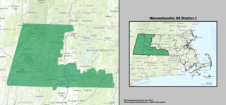
Massachusetts's 1st congressional district is a United States congressional district located in the western and central part of Massachusetts. The state's largest congressional district in area, it covers about one-third of the state and is more rural than the rest. It has the state's highest point, Mount Greylock; the district includes the cities of Springfield, West Springfield, Pittsfield, Holyoke, Agawam, Chicopee and Westfield.

Massachusetts's 2nd congressional district is located in central Massachusetts. It contains the cities of Worcester, which is the second-largest city in New England after Boston, and Northampton in the Pioneer Valley. It is represented by Democrat Jim McGovern.

The M1917 Enfield, the "American Enfield", formally named "United States Rifle, cal .30, Model of 1917" is an American modification and production of the .303-inch Pattern 1914 Enfield (P14) rifle, which was developed and manufactured during the period 1917–1918. Numerically, it was the main rifle used by the American Expeditionary Forces in Europe during World War I. The Danish Sirius Dog Sled Patrol on Greenland still use the M1917, which performs reliably in Arctic conditions, as their service weapon.

The 17th congressional district of Illinois is represented by Democrat Cheri Bustos. It includes most of the northwestern portion of the state, with most of its population living on the Illinois side of the Quad Cities, as well as parts of Peoria and Rockford.

The United States Medical Center for Federal Prisoners is a United States federal prison in Springfield, Missouri which provides medical, mental health, and dental services to male offenders. It is operated by the Federal Bureau of Prisons, a division of the United States Department of Justice.

The Montrealer was an overnight passenger train between Washington, D.C., United States, and Montreal, Quebec, Canada. The train was operated from 1924 to 1966, and again under Amtrak from 1972 to 1995, excepting two years in the 1980s. The train was discontinued in 1995 and replaced by the Vermonter, which provides daytime service as far north as St. Albans, Vermont.

Springfield Center is a hamlet in the town of Springfield, Otsego County, New York, United States. Springfield Center is located on New York State Route 80, 9.2 miles (14.8 km) north-northeast of the Village of Cooperstown. Springfield Center has a post office with ZIP code 13468, which opened on July 16, 1850.

