Edmeston, New York

Last updated

Edmeston, New York
Otsego County outline map Edmeston red.png
Edmeston, Otsego County
Coordinates: 42°43′N75°15′W / 42.717°N 75.250°W / 42.717; -75.250
Country United States
State New York
County Otsego
Area
[1]
  Total44.38 sq mi (114.95 km2)
  Land44.30 sq mi (114.74 km2)
  Water0.08 sq mi (0.21 km2)
Elevation
1,430 ft (436 m)
Population
 (2010)
  Total1,826
  Estimate 
(2018) [2]
1,744
  Density39.39/sq mi (15.21/km2)
Time zone UTC-5 (Eastern (EST))
  Summer (DST) UTC-4 (EDT)
ZIP code
13335
Area code 607
FIPS code 36-23613
GNIS feature ID0978926
Website www.edmestonny.org

Edmeston is a town located in Otsego County, New York, United States. As of the 2010 census, the town had a total population of 1,826.

Contents

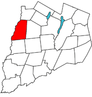
The Town of Edmeston is at the western county line. Edmeston is also the name of the largest hamlet in the town. The town is south of Utica.

Geography

According to the United States Census Bureau, the town has a total area of 44.6 square miles (116 km2), of which 44.5 square miles (115 km2) is land and 0.1 square miles (0.26 km2) is water. The total area is 0.11% water. The major water features are:

The elevation of the town varies by approximately 800 feet (240 m): from just under 1,100 feet (340 m) above sea level at the Unadilla River in the southwestern corner of the town, to just over 1,900 feet (580 m) at peaks near Taylor Hill and Summit Lake in the northeastern corner.

New York State Route 80 passes through the southeastern part of the town.

History

The town of Edmeston, in Otsego County, extends to the west as far as the Unadilla River, a line that was established by the 1768 Treaty of Fort Stanwix between the British and the Iroquois, negotiated by Sir William Johnson. The town's name came from the brothers, Robert and William Edmeston, who had been granted 10,000 acres (40 km2) of land in what is now the northwest corner of the town. The hamlets of West Edmeston and South Edmeston are situated in the Unadilla Valley, while the hamlet of Edmeston lies in the Wharton Valley. Earlier settlers came from New England; for most of the settlers, it was planned as a stopover on their way west. A strong Baptist influence came with the settlers. Universalists, Methodists and Roman Catholics soon arrived.

The town was established from the Town of Burlington in 1808.

Dairy farming has historically been the main business of the area. Cheese factories, creameries, livery stables, blacksmith shops, and tanneries were created to support the dairy industry. One room schoolhouses were scattered throughout the town. By damming the creeks, power was created for foundries and mills. Hop growing and maple syrup production were seasonal occupations. Each of the town's communities developed business districts and became self-sufficient. The last spike of the Edmeston branch of the Ontario & Western RR from New Berlin, was driven at Edmeston in January 1889, but a rumored extension to Richfield Springs was never built. Then cars, buses and trucks arrived on the scene. Dams were washed out and electricity became available. The hamlets evolved into bedroom communities. The one room schoolhouses closed and the Central School was developed in the hamlet of Edmeston.

Today residents go in all four directions for employment. NYCM Insurance not only provides positions for many of the locals but also for hundreds that commute into the community each day. On the eastern side of the town is the Pathfinder Village (home for Down syndrome residents) that provides more employment.

The population of the town has not increased much through the years. It still remains largely rural. Organizations like the local Rotary Club, American Legion and Fire and Emergency Squads have active volunteers that provide community needs in lieu of governments in the hamlets. Edmeston Central School is the center of activities.

Demographics

Historical population
CensusPop.Note
1820 1,841
1830 2,08713.4%
1840 1,907−8.6%
1850 1,885−1.2%
1860 1,804−4.3%
1870 1,744−3.3%
1880 1,7942.9%
1890 1,703−5.1%
1900 1,7673.8%
1910 1,567−11.3%
1920 1,553−0.9%
1930 1,5560.2%
1940 1,5801.5%
1950 1,563−1.1%
1960 1,72110.1%
1970 1,709−0.7%
1980 1,7321.3%
1990 1,717−0.9%
2000 1,8246.2%
2010 1,8260.1%
2016 (est.)1,745 [2] −4.4%
U.S. Decennial Census [3]

As of the census [4] of 2000, the town of Edmeston contained:

The population density was 40.9 inhabitants per square mile (15.8/km2).

There were 821 housing units at an average density of 18.4 per square mile (7.1/km2).

The racial makeup of the town was:

There were 658 households, out of which:

The spread of the population of Edmeston was:

Edmeston population distribution (2000 Census)

AgeTotal% *Male% **Female%**
All1824100.091250.091250.0
18+133072.965736.067336.9
21+128270.3----
60+35219.316647.218652.8
62+32417.8----
65+26514.512647.513952.5
75+1186.54941.56958.5
85+251.4936.01664.0
(*) percent of total population (all ages)
(**) percent of population in age bracket

The median age was 37 years.

For every 100 females, there were 100.0 males.
For every 100 females age 18 and over, there were 97.6 males.

In the town of Edmeston, median income:

The per capita income for the town was $17,507.

13.6% of the population and 8.3% of families were below the poverty line.

Out of the total people living in poverty,

Communities and locations in Edmeston

See also

Related Research Articles

<span class="mw-page-title-main">Otsego County, New York</span> County in New York, United States

Otsego County is a county in the U.S. state of New York located within the Mohawk Valley Region. As of the 2020 census, the population was 58,524. The county seat is Cooperstown. The county's population center is Oneonta. The name Otsego is from a Mohawk or Oneida word meaning "place of the rock." The county is part of the Mohawk Valley region of the state.

<span class="mw-page-title-main">Columbus, New York</span> Town in New York, United States

Columbus is a town in Chenango County, New York, United States. The population was 975 at the 2010 census. Columbus is in the northeastern corner of the county and is northeast of Norwich.

<span class="mw-page-title-main">Guilford, New York</span> Town in New York, United States

Guilford is a town in Chenango County, New York, United States. The town is on the eastern border of the county. The population was 2,922 at the 2010 census.

<span class="mw-page-title-main">Columbia, New York</span> Town in New York, United States

Columbia is a town in Herkimer County, New York, United States. As of the 2020 census, the town population was 1,569. The town is at the southern border of the county and is southeast of Utica.

<span class="mw-page-title-main">Winfield (town), New York</span> Town in New York, United States

Winfield is a town in Herkimer County, New York, United States. The population was 2,086 at the 2010 census. The town is named after General Winfield Scott and is in the southwestern corner of the county, south of Utica.

Brookfield is a town in Madison County, New York, United States. The population was 2,403 at the 2000 census.

<span class="mw-page-title-main">Burlington, New York</span> Town in New York, United States

Burlington is a town in Otsego County, New York, United States. The population was 1,140 at the 2010 census.

<span class="mw-page-title-main">Butternuts, New York</span> Town in New York, United States

Butternuts is a town located in Otsego County, New York, United States. As of the 2010 census, the town had a population of 1,786. The Town of Butternuts is located in the southwestern part of the county, and is west of Oneonta.

<span class="mw-page-title-main">Exeter, New York</span> Town in New York, United States

Exeter is a town in Otsego County, New York, United States. The town is located in the northern part of the county. The population was 987 at the 2010 census. It is named after the county town and cathedral city of Exeter in England.

<span class="mw-page-title-main">Middlefield, New York</span> Town in New York, United States

Middlefield is a town in Otsego County, New York, United States. The population was 2,114 at the 2010 census.

<span class="mw-page-title-main">Otsego, New York</span> Town in New York, United States

Otsego is a town in the north-central part of Otsego County, New York, United States. The population was 3,641 at the 2020 census. The town is named after Lake Otsego, which forms part of the town's eastern border.

<span class="mw-page-title-main">Pittsfield, New York</span> Town in New York, United States

Pittsfield is a town in Otsego County, New York, United States. The population was 1,366 at the 2010 census.

<span class="mw-page-title-main">Plainfield, New York</span> Town in New York, United States

Plainfield is a town in Otsego County, New York, United States. The population was 915 at the 2010 census.

<span class="mw-page-title-main">Roseboom, New York</span> Town in New York, United States

Roseboom is a town in Otsego County, New York, United States. The population was 711 at the 2010 census. The name of the town is taken from those of early landowners and settlers Abram and John Roseboom.

<span class="mw-page-title-main">Summit, New York</span> Town in New York, United States

Summit is a town in Schoharie County, New York, United States. The population was 1,072 at the time of the 2020 census. The name is derived from a peak that was thought to be the highest elevation in the county.

<span class="mw-page-title-main">New Berlin, New York</span> Town in New York, United States

New Berlin is a town in Chenango County, central New York, United States. The population was 2,682 at the 2010 census. The town contains the village of New Berlin. The town is at the eastern border of the county and is northeast of Norwich.

<span class="mw-page-title-main">Milford, New York</span> Town in New York, United States

Milford is a town in Otsego County, New York, United States. The population was 3,044 at the 2010 census. Within town is the village of Milford. The town is northeast of the City of Oneonta.

<span class="mw-page-title-main">Otego (town), New York</span> Town in New York, United States

Otego is a town in Otsego County, New York, United States. The population was 3,115 at the 2010 census. The name is a native word meaning "where there is fire."

<span class="mw-page-title-main">Unadilla (village), New York</span> Village in New York, United States

Unadilla is a village located in the Town of Unadilla in Otsego County, New York, United States. The population was 1,128 at the 2010 census.

<span class="mw-page-title-main">Unadilla, New York</span> Town in New York, United States

Unadilla is a town in Otsego County, New York, United States. As of the 2010 census, the town had a population of 4,392. The name is derived from an Iroquois word for "meeting place". Unadilla is located in the southwestern corner of the county, southwest of Oneonta. The village of Unadilla is located in the southern part of the town. The mayor of Unadilla is Jason Cotten.

References

  1. "2016 U.S. Gazetteer Files". United States Census Bureau. Retrieved July 5, 2017.
  2. 1 2 "Population and Housing Unit Estimates" . Retrieved November 5, 2019.
  3. "Census of Population and Housing". Census.gov. Retrieved June 4, 2015.
  4. "U.S. Census website". United States Census Bureau . Retrieved January 31, 2008.