
Beaver County is a county in west central Utah, United States. As of the 2020 United States Census, the population was 7,072, up from the 2010 figure of 6,629. Its county seat and largest city is Beaver. The county was named for the abundance of beaver in the area.

Beaver is a city in, and county seat of, Beaver County in southwestern Utah, United States. The population was 3,592 at the 2020 census, up from the 2010 figure of 3,112.

The Truckee River is a river in the U.S. states of California and Nevada. The river flows northeasterly and is 121 miles (195 km) long. The Truckee is the sole outlet of Lake Tahoe and drains part of the high Sierra Nevada, emptying into Pyramid Lake in the Great Basin. Its waters are an important source of irrigation along its valley and adjacent valleys.

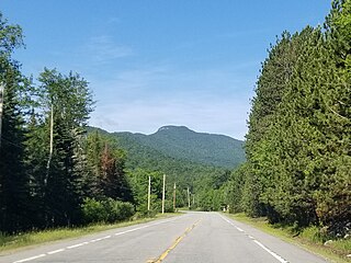
Trail Ridge Road is the name for the 48-mile (77 km) stretch of U.S. Highway 34 that traverses Rocky Mountain National Park from Estes Park, Colorado in the east to Grand Lake, Colorado in the west. Together with the connecting 6.9-mile (11 km) Beaver Meadow Road, Trail Ridge Road forms the 55-mile (89 km) Trail Ridge Road/Beaver Meadow National Scenic Byway, an All-American Road. With a high point at 12,183 feet (3,713 m) elevation, Trail Ridge Road is the highest continuous paved road in North America. The higher portion of Trail Ridge Road is closed from October to May.

The Walker River is a river in west-central Nevada in the United States, approximately 62 miles (100 km) long. Fed principally by snowmelt from the Sierra Nevada of California, it drains an arid portion of the Great Basin southeast of Reno and flows into the endorheic basin of Walker Lake. The river is an important source of water for irrigation in its course through Nevada; water diversions have reduced its flow such that the level of Walker Lake has fallen 160 feet (49 m) between 1882 and 2010. The river was named for explorer Joseph Reddeford Walker, a mountain man and experienced scout who is known for establishing a segment of the California Trail.

The Owens River is a river in eastern California in the United States, approximately 183 miles (295 km) long. It drains into and through the Owens Valley, an arid basin between the eastern slope of the Sierra Nevada and the western faces of the Inyo and White Mountains. The river terminates at the endorheic Owens Lake south of Lone Pine, at the bottom of a 2,600 sq mi (6,700 km2) watershed.

The Methow River is a tributary of the Columbia River in northern Washington in the United States. The river's 1,890-square-mile (4,900 km2) watershed drains the eastern North Cascades, with a population of about 5,000 people. The Methow's watershed is characterized by relatively pristine habitats, as much of the river basin is located in national forests and wildernesses. Many tributaries drain the large Pasayten Wilderness. An earlier economy based on agriculture is giving way to one based on recreation and tourism.

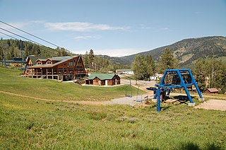
Beaver Creek Resort is an alpine ski resort in the western United States, near Avon, Colorado. The resort comprises three villages, the main Beaver Creek Village, Bachelor Gulch, and Arrowhead to the west. The resort is owned and operated by Vail Resorts which operates multiple additional resorts. Beaver Creek is a regular host of World Cup events, usually in early December.

Kenosee Lake is a closed-basin lake in the south-east corner of the Canadian province of Saskatchewan. The lake lies in Moose Mountain Provincial Park in the heart of the Moose Mountain Upland, a forested plateau that rises about 200 metres (660 ft) above the surrounding prairie.

Broken Bow Lake is a reservoir in southeastern Oklahoma, located on Mountain Fork River and 9 miles (14 km) northeast of the town of Broken Bow in McCurtain County. It is one of the largest fresh water lakes within the state of Oklahoma, and a popular tourist destination for locals and visitors from neighboring Texas and Arkansas.
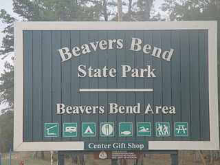
Beavers Bend State Park is a 3,482 acres (14.09 km2) Oklahoma state park located in McCurtain County. It is approximately 10.5 miles (16.9 km) north of Broken Bow on SH-259A. It was established in 1937 and contains Broken Bow Lake.

Strawberry Mountain Wilderness is a wilderness area of the Strawberry Mountain Range, within Malheur National Forest in the Blue Mountains of east Oregon. The area comprises 69,350 acres (28,060 ha), including mountain peaks and several lakes, and contains more than 125 miles (201 km) of hiking trails. Strawberry Mountain was designated wilderness under the Wilderness Act of 1964, and in 1984 more than doubled in size with the passage of the Oregon Wilderness Act. It is managed by the United States Forest Service.
Beaver Mountain is a ski area in the western United States, in northern Utah. First opened 85 years ago in 1939, it is located near the summit of Logan Canyon in the Bear River Mountains, west of Bear Lake and near the border with Idaho. While smaller and less developed than a number of Utah ski resorts, Beaver Mountain is very popular with residents of nearby Logan, Utah State University, the surrounding Cache Valley, and the Bear Lake region, including southeastern Idaho.
The Sakāwithiniwak or Woodland Cree, are a Cree people, calling themselves Nîhithaw in their own dialect of the language. They are the largest indigenous group in northern Alberta and are an Algonquian people. Prior to the 18th century, their territory extended west of Hudson Bay, as far north as Churchill. Although in western Northern Saskatchewan and Manitoba, by the 18th century, they acted as middlemen in trade with western tribes. After acquiring guns through trade, they greatly expanded their territory and drove other tribes further west and north.
The West Canada Lake Wilderness Area is an Adirondack Park Forest Preserve management unit in the State of New York, USA.

Moose Mountain Provincial Park is a provincial park, in south-eastern Saskatchewan about 24 kilometres (15 mi) north of the town of Carlyle on the Moose Mountain Upland. It is one of Saskatchewan's few parks with a community inside the park as there are several subdivisions with both year-round and seasonal residents. The village of Kenosee Lake is completely surrounded by the park but is not part of the park.
Snowy Mountain is a mountain located in Hamilton County, New York. Initially known as 'Squaw Bonnet', its summit is the highest point in the county. While most maps show the elevation as 3899 feet, some suggest that more recent surveys have it as 3904 feet or even 3908 feet.

Graham Mountain is the seventh highest of the Catskill High Peaks and the highest privately owned mountain in the range. It is located in the town of Hardenburgh, New York, United States.

White Bear (Carlyle) Lake is a closed-basin lake in the Moose Mountain Upland. It is the largest lake on the plateau, slightly larger than its neighbour, Kenosee Lake. White Bear (Carlyle) Lake is within the White Bear 70 Indian reserve and Carlyle Lake Resort is along the southern shore. The lake and its amenities are accessed from Highway 9.

