The Cuyahoga River is a river located in Northeast Ohio that bisects the City of Cleveland and feeds into Lake Erie.

The Kiskiminetas River is a tributary of the Allegheny River, approximately 27 miles (43 km) long, in Western Pennsylvania in the United States. The region stretching from the northern side of Harmar Township, Pennsylvania to the Kiskiminetas towns is often referred to by the locals as the Alle-Kiski Valley after the rivers.

The Unadilla River is a 71-mile-long (114 km) river in the Central New York Region of New York State. The river begins northeast of the hamlet of Millers Mills and flows generally south to the village of Sidney, where it converges with the Susquehanna River, which drains into the Chesapeake Bay, a bay of the Atlantic Ocean.

The Chippewa River is a stream in Michigan, United States, that runs 91.8 miles (147.7 km) through the central Lower Peninsula. The Chippewa is a tributary of the Tittabawassee River and is thus part of the Saginaw River drainage basin. The river is named after the Chippewa people.
Carp River is a 40.2-mile-long (64.7 km) river in Chippewa and Mackinac counties in the U.S. state of Michigan. 21.7 miles (34.9 km) of the river were added to the National Wild and Scenic Rivers System in 1992.
The Black River is a 41.1-mile-long (66.1 km) river on the Upper Peninsula of the U.S. state of Michigan, flowing mostly in Gogebic County into Lake Superior at 46°40′03″N90°02′57″W. Its source at 46°18′54″N90°01′15″W is a boreal wetland on the border with Iron County, Wisconsin. The northern section of the river, 14 miles (23 km) within the boundaries of the Ottawa National Forest, was designated a National Wild and Scenic River in 1992.
Cedar River is a 67.1-mile-long (108.0 km) river in the U.S. state of Michigan. It rises in the northern part of Menominee County at 45°53′18″N87°35′15″W and flows mostly south and east to empty into Green Bay of Lake Michigan at 45°24′35″N87°21′05″W in the community of Cedar River.

Wappinger Creek is a 41.7-mile-long (67.1 km) creek which runs from Thompson Pond to the Hudson River at New Hamburg in Dutchess County, New York, United States. It is the longest creek in Dutchess County, with the largest watershed in the county.

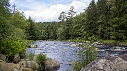
The Cedar River is a 38.5-mile-long (62.0 km) river in the central Adirondacks, in Hamilton County, New York. It rises at the outlet of Cedar Lake in the Town of Arietta and flows northeast into the Town of Lake Pleasant, where it passes through the Cedar River Flow. Continuing northeast and east, it passes through the Town of Indian Lake and remote corners of the Towns of Minerva and Newcomb to join the Hudson River northeast of the hamlet of Indian Lake. The Northville-Placid Trail goes past the Cedar Lakes and along the Cedar River to the flow.
Fowlerville is a small hamlet in the town of Concord, in southern Erie County, New York, United States.

The Pine River is a 103-mile-long (166 km) river in the Lower Peninsula of the U.S. state of Michigan. The Pine River is a tributary of the Chippewa River and is thus part of the Saginaw River drainage basin.

Henderson Lake is a lake in the Adirondack mountains in the town of Newcomb, Essex County, New York in the United States. It was named in 1826 after David Henderson, one of the founders of the Elba Iron Works near Lake Placid, New York, and of the Upper Works at Tahawus, New York. The lake is mainly cited by cartographers as the place where the Hudson River as named officially begins, flowing out of the eastern end and outlet of the lake. Unofficially, the source of the river is traced up Indian Pass Brook and other watercourses to Lake Tear of the Clouds.
Lidell Creek is a small creek in the town of Exeter in Otsego County, New York. Lidell Creek flows into Oaks Creek by Lidell Corners, south of the Hamlet of Schuyler Lake.
Caroga Creek is a river in Fulton and Montgomery counties in the U.S. State of New York. It begins at East Caroga Lake and flows south passing through Rockwood Lake before converging with the Mohawk River in the Hamlet of Palatine Church.

Sprite Creek is a river in Fulton County and Herkimer County in the U.S. State of New York. It begins at Canada Lake northwest of the Hamlet of Caroga Lake, and flows through Lily Lake before converging with the East Canada Creek northeast of the Village of Dolgeville.

Rum Hill is a mountain located in Central New York Region of New York northwest of the Hamlet of Pierstown. Red House Hill is located southeast, Metcalf Hill is located south, Allen Lake and Mohegan Hill are located north-northwest and Otsego Lake is located east of Rum Hill.

Indian Lake is a hamlet located in the Town of Indian Lake in Hamilton County, New York, United States. Adirondack Lake is located northeast of the hamlet and Indian Lake is located south of the hamlet. NY 28 and NY 30 run through the hamlet.

Boreas River is a river in Essex County and Hamilton County in the U.S. State of New York. Boreas River begins at Boreas Ponds north-northeast of the Hamlet of Boreas River and flows southeastward before converging with the Hudson River southeast of Forks Mountain.