Canajoharie is a town in Montgomery County, New York, United States. The population was 3,730 in 2010. Canajoharie is located south of the Mohawk River on the southern border of the county. The Erie Canal passes along the northern town line. There is also a village of Canajoharie in the town. Both are east of Utica and west of Amsterdam.

The Mohawk River is a 149-mile-long (240 km) river in the U.S. state of New York. It is the largest tributary of the Hudson River. The Mohawk flows into the Hudson in Cohoes, New York, a few miles north of the state capital of Albany. The river is named for the Mohawk Nation of the Iroquois Confederacy. A major waterway, in the early 19th century, the river's east-west valley provided the setting and water for development of the Erie Canal, as a key to developing New York. The largest tributary, the Schoharie Creek, accounts for over one quarter (26.83%) of the Mohawk River's watershed. Another main tributary is the West Canada Creek, which makes up for 16.33% of the Mohawk's watershed.

The Chenango River is a 90-mile-long (140 km) tributary of the Susquehanna River in central New York in the United States. It drains a dissected plateau area in upstate New York at the northern end of the Susquehanna watershed.

The West Branch Delaware River is one of two branches that form the Delaware River. It is approximately 90 mi (144 km) long, and flows through the U.S. states of New York and Pennsylvania. It winds through a mountainous area of New York in the western Catskill Mountains for most of its course, before joining the East Branch along the northeast border of Pennsylvania with New York. Midway or so it is empounded by the Cannonsville Dam to form the Cannonsville Reservoir, both part of the New York City water supply system for delivering drinking water to the City.

The Sacandaga River is a 64-mile-long (103 km) river in the northern part of New York in the United States. Its name comes from the Native American Sa-chen-da'-ga, meaning "overflowed lands".

The Cranberry River is a tributary of the Gauley River located in southeastern West Virginia in the United States. It is a part of the Mississippi River watershed, by way of the Gauley, Kanawha, and Ohio Rivers, draining an area of 74 square miles (192 km2).
Matchaponix Brook is a tributary of the South River in Monmouth and Middlesex counties, New Jersey in the United States.

New York State Route 163 (NY 163) is an 11.97-mile-long (19.26 km) east–west state highway in Montgomery County, New York, in the United States. It runs in the shape of a C from an intersection with NY 5S and NY 80 in the village of Fort Plain to a junction with NY 10 in the town of Canajoharie. With the exception of its eastern terminus, NY 163 is not signed with directions. Reference markers indicate its terminus in Fort Plain to be its western, although the route heads nearly due southward until Sprout Brook. Approaching that hamlet, it is named Cherry Valley Road, and when NY 163 turns left to head eastward, County Route 82 (CR 82) continues that road name directly to NY 166 which leads to Cherry Valley. In Fort Plain, NY 163 follows Kellogg and Douglas streets. NY 163 is a two-lane highway for its entire length. The route was assigned as part of the 1930 renumbering of state highways in New York and originally continued north to the village of Canajoharie via NY 10.

Coyote Creek is a principal tributary of the San Gabriel River in northwest Orange County and southeast Los Angeles County, California. It drains a land area of roughly 41.3 square miles (107 km2) covering eight major cities, including Brea, Buena Park, Fullerton, Hawaiian Gardens, La Habra, Lakewood, La Palma, and Long Beach. Some major tributaries of the creek in the highly urbanized watershed include Brea Creek, Fullerton Creek, and Carbon Creek. The mostly-flat creek basin is separated by a series of low mountains, and is bounded by several small mountain ranges, including the Chino Hills, Puente Hills, and West Coyote Hills.
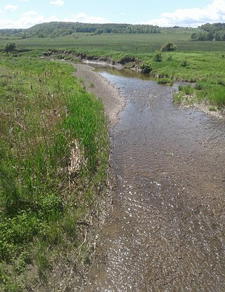
Sprout Brook is a hamlet in the Town of Canajoharie in Montgomery County, New York, United States. It is located 60 miles (97 km) west of Albany. New York State Route 163 (NY 163) passes through the hamlet, as does Bowmans Creek.
Oaks Creek is a river that drains Canadarago Lake, which is situated in the north central region of Otsego County, New York. The creek begins by the Hamlet of Schuyler Lake and flows southeast approximately 9.32 miles (15.00 km), dropping only 105 feet (32 m) in elevation, before converging with the Susquehanna River south of the Village of Cooperstown, by the Hamlet of Index. From the source to Oaksville the creek flows along Panther Mountain. Fly Creek is a main tributary, that converges with Oaks Creek south of the Hamlet of Fly Creek.
Ocquionis Creek, also known as Fish Creek, is a river in southern Herkimer County and northern Otsego County in the State of New York. It begins northeast of the Hamlet of Jordanville and flows generally southward before flowing into the northern end of Canadarago Lake south of the Village of Richfield Springs. Ocquionis is an Iroquois word that translates to "he is a bear".
Otsquago Creek is a river that enters the Mohawk River in Fort Plain, New York. Otsquago is a Mohawk Indian word meaning 'under the bridge,' probably referring to an early bridge of felled trees along the creek, a way of making small bridges. It is also referred to as Otsquage on old maps, which is an Indian word for 'healing waters'.

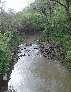
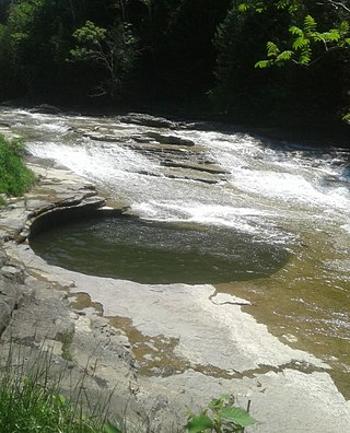
The Canajoharie Creek is a river that flows into the Mohawk River in the Village of Canajoharie in the U.S. State of New York. The name "Canajoharie" is a Mohawk language term meaning "the pot that washes itself", referring to the "Canajoharie Boiling Pot", a 20-foot (6.1 m) wide and 10-foot (3.0 m) deep pothole in the Canajoharie Creek, just south of the village of Canajoharie. Bowmans Creek is one main tributary that enters the creek east of the Hamlet of Sprout Brook. The other main tributary is Brimstone Creek which enters the creek north-northwest of the Village of Ames.

Steele Creek is a river in Herkimer County in the state of New York. The creek begins in an unnamed swamp south of Cedarville, and flows in a northeast direction before emptying into the Mohawk River in the village of Ilion. Steele Creek travels through the Ilion Gorge and alongside NY-51 for most of its length. Steele Creek derives its name from Rudolph Stahl, who built the first grist mill in Ilion along the creek.
Kayaderosseras Creek also called Kaniatarósera'as Stream is a river located in Montgomery and Fulton counties in the state of New York. The creek begins southeast of Johnstown and flows in a generally southeast direction before converging with the Mohawk River by Fort Johnson, just west of Amsterdam. Kaniatarósera'as Stream, is a Mohawk name which translates to "waves splashing".
Falls Creek is a river in Delaware County in the state of New York. It begins east of the hamlet of Meredith and flows in a generally southeast direction before flowing into the West Branch Delaware River north-northeast of the village of Delhi. Watauga Falls is a waterfall located on the creek.

Little Delaware River is a river in Delaware County, New York. It begins along the western slope of Plattekill Mountain, northeast of the Hamlet of Bovina and flows generally westward before converging with the West Branch Delaware River by the Village of Delhi.
Roods Creek is a river in Delaware County, New York. It begins just south of Cannonsville Reservoir and flows south into Crystal Lake. After exiting Crystal Lake it continues flowing south and then flows into Silver Lake. After exiting Silver Lake it continues southward before converging with the West Branch Delaware River east of the hamlet of Hale Eddy.
Brimstone Creek is a river in Schoharie County and Montgomery County in New York. It begins east of the Village of Sharon Springs and flows mostly in a northwest direction before flowing into Canajoharie Creek north-northwest of the Village of Ames.