
Springfield Township is one of twenty townships in Allen County, Indiana, United States. As of the 2010 census, its population was 4,349. The principal town in Springfield Township is the village of Harlan.

Newville Township is one of fifteen townships in DeKalb County, Indiana. As of the 2010 census, its population was 558 and it contained 196 housing units.
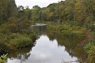
Pine Creek is a 23.7-mile-long (38.1 km) tributary of the Mississippi River in Winona and Houston counties, Minnesota, United States. Pine Creek joins the Mississippi southeast of La Crescent, Minnesota, directly across from La Crosse, Wisconsin.

Willow Creek is a 79-mile (127 km) long tributary of the Columbia River, located in the U.S. state of Oregon. It drains 880 square miles (2,279 km2) of Morrow and Gilliam counties. Arising in the Blue Mountains, it flows generally northwest to its confluence with the Columbia River upstream of Arlington.

Bully Creek is a 62-mile (100 km) long tributary of the Malheur River, located in the U.S. state of Oregon. It drains 601 square miles (1,557 km2) of Malheur County. Arising in the Blue Mountains, it flows generally southeast to its confluence with the Malheur River near Vale.

Newville is a hamlet in the town of Danube, in Herkimer County, New York, United States. Newville is located on Nowadaga Creek, 4.9 miles (7.9 km) south-southeast of Little Falls.

Neepaulakating Creek is a 2.4-mile long (3.8 km) tributary of Papakating Creek in Wantage Township in Sussex County, New Jersey in the United States. It is one of three streams feeding the Papakating Creek, a major contributor to the Wallkill River. Although the stream was dammed in the 1950s to create Lake Neepaulin as the focal point of a private residential development, the stream did not receive a name until 2002. Residents chose a name that combined elements of the names "Neepaulin" and "Papakating", and submitted a proposal to the United States Board of Geographic Names. The name was approved in 2004.
Oaks Creek is a river that drains Canadarago Lake, which is situated in the north central region of Otsego County, New York. The creek begins by the Hamlet of Schuyler Lake and flows southeast approximately 9.32 miles (15.00 km), dropping only 105 feet (32 m) in elevation, before converging with the Susquehanna River south of the Village of Cooperstown, by the Hamlet of Index. From the source to Oaksville the creek flows along Panther Mountain. Fly Creek is a main tributary, that converges with Oaks Creek south of the Hamlet of Fly Creek.

Butternut Creek is a 37-mile-long (60 km) river in the state of New York. It converges with the Unadilla River just downstream of Mount Upton. The creek has many fish for fishing dominated by largemouth bass, smallmouth bass, wall-eye, chain pickerel, rock bass, and yellow perch.

The Canajoharie Creek is a river that flows into the Mohawk River in the Village of Canajoharie in the U.S. State of New York. The name "Canajoharie" is a Mohawk language term meaning "the pot that washes itself", referring to the "Canajoharie Boiling Pot", a 20-foot (6.1 m) wide and 10-foot (3.0 m) deep pothole in the Canajoharie Creek, just south of the village of Canajoharie. Bowmans Creek is one main tributary that enters the creek east of the Hamlet of Sprout Brook. The other main tributary is Brimstone Creek which enters the creek north-northwest of the Village of Ames.

Nowadaga Creek is a river in Herkimer County in the state of New York. The basin drains portions of the towns of Danube, Stark, and Little Falls, as well as a small portion of the town of Warren, in southern Herkimer County before converging with the Erie Canal in Indian Castle, New York. The drainage basin is approximately 49 percent forested. The creek has an average slope of 1.7 percent over its entire stream length of 10.0 miles. On a 1790 land patent map it is spelled "Inchanando Creek".

Steele Creek is a river in Herkimer County in the state of New York. The creek begins in an unnamed swamp south of Cedarville, and flows in a northeast direction before emptying into the Mohawk River in the village of Ilion. Steele Creek travels through the Ilion Gorge and alongside NY-51 for most of its length. Steele Creek derives its name from Rudolph Stahl, who built the first grist mill in Ilion along the creek.

Caroga Creek is a river in Fulton and Montgomery counties in the U.S. State of New York. It begins at East Caroga Lake and flows south passing through Rockwood Lake before converging with the Mohawk River in the Hamlet of Palatine Church.
Cobleskill Creek is a river in Otsego and Schoharie counties in the state of New York. It starts at Pine Mountain west of West Richmondville and flows east-northeast before converging with Schoharie Creek in Central Bridge. The creek flows through the villages of Richmondville and Cobleskill.
Falls Creek is a river in Delaware County in the state of New York. It begins east of the hamlet of Meredith and flows in a generally southeast direction before flowing into the West Branch Delaware River north-northeast of the village of Delhi. Watauga Falls is a waterfall located on the creek.

Bowmans Creek is a river in Montgomery County, New York. It begins west of the hamlet of Hessville and just south of the hamlet of Ripple Corners. It then flows in a mostly southeast direction for a few miles passing through the hamlet of Sprout Brook before flowing into the Canajoharie Creek just east of the hamlet of Sprout Brook.

Conneauttee Creek is a 13.26 mi (21.34 km) long 4th order tributary to French Creek in Crawford County, Pennsylvania. This is the only stream of this name in the United States.

Whitethorn Creek is a 15.01 mi (24.16 km) long 4th order tributary to the Banister River in Pittsylvania County, Virginia. The Whitehorn Creek watershed and its tributary, Mill Creek, are the location of one of the largest uranium deposits in the United States on Cole Hill.

