The Advisory Committee on Antarctic Names is an advisory committee of the United States Board on Geographic Names responsible for recommending commemorative names for features in Antarctica.
The UK Antarctic Place-Names Committee is a United Kingdom government committee, part of the Foreign and Commonwealth Office, responsible for recommending names of geographical locations within the British Antarctic Territory (BAT) and the South Georgia and the South Sandwich Islands (SGSSI). Such names are formally approved by the Commissioners of the BAT and SGSSI respectively, and published in the BAT Gazetteer and the SGSSI Gazetteer maintained by the Committee. The BAT names are also published in the international Composite Gazetteer of Antarctica maintained by SCAR.

The Chippewa River is a stream in Michigan, United States, that runs 91.8 miles (147.7 km) through the central Lower Peninsula. The Chippewa is a tributary of the Tittabawassee River and is thus part of the Saginaw River drainage basin. The river is named after the Chippewa people.

Wappinger Creek is a 41.7-mile-long (67.1 km) creek which runs from Thompson Pond to the Hudson River at New Hamburg in Dutchess County, New York, United States. It is the longest creek in Dutchess County, with the largest watershed in the county.
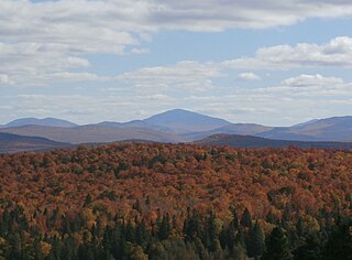
Snow Mountain is a mountain located in Franklin County, Maine, about 5 mi (8 km) from the Canada–United States border. Snow Mtn. is flanked to the northeast by Bag Pond Mountain, and to the southeast by Round Mountain.

Thatcher Peninsula is a mountainous peninsula in north-central South Georgia. Its total area is approximately 5,640 hectares, with roughly 1,620 ha covered in vegetation. It terminates to the north in Mai Point, rising between Cumberland West Bay to the west, and Cumberland East Bay and Moraine Fjord to the east. It is bounded to the southwest and south by Lyell Glacier and Hamberg Glacier. King Edward Cove on the east side of the peninsula is the site of the British Antarctic Survey (BAS) Grytviken station and the disused whaling station of the same name.

Allen Mountain is located in Essex County, New York. It is part of the Marcy Group of the Great Range of the Adirondack Mountains, and is flanked to the north by Mount Skylight.
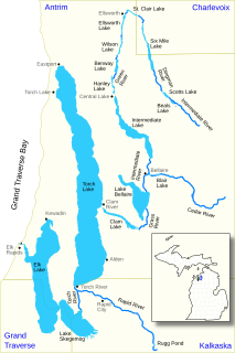
The Elk River Chain of Lakes Watershed is a 75-mile-long (121 km) waterway consisting of 14 lakes and connecting rivers in the northwestern section of the Lower Peninsula of the U.S. state of Michigan, which empty into Lake Michigan.

The Cedar River is a 38.5-mile-long (62.0 km) river in the central Adirondacks, in Hamilton County, New York. It rises at the outlet of Cedar Lake in the Town of Arietta and flows northeast into the Town of Lake Pleasant, where it passes through the Cedar River Flow. Continuing northeast and east, it passes through the Town of Indian Lake and remote corners of the Towns of Minerva and Newcomb to join the Hudson River northeast of the hamlet of Indian Lake. The Northville-Placid Trail goes past the Cedar Lakes and along the Cedar River to the flow.
The Ducktrap River is a river in Waldo County, Maine. From the outflow in Tilden Pond in Belmont, the river runs 10.0 miles (16.1 km) southeast, through Camden Hills State Park, to West Penobscot Bay in Lincolnville.

The Goose River is a river in Knox County, Maine. From the outflow of Hosmer Pond in Camden, the river runs 4.4 miles (7.1 km) southeast to Rockport Harbor, in Rockport.
The Middle Branch Pleasant River is a tributary of the Piscataquis River in Piscataquis County, Maine. From the outflow of Middle Branch Pond in Maine Township 5, Range 9, WELS, the river runs 11.4 miles (18.3 km) southeast to its confluence with the East Branch in Brownville. The East Branch runs about 1.5 miles (2.4 km) further south, joining with the West Branch to form the main stem of the Pleasant River.
Bullseye Lake is a very small pond lying near the center of an elliptical depression in the Insel Range, 4.5 nautical miles (8 km) northeast of Mount Boreas, in Victoria Land. The name was applied in 1964 by American geologist Parker E. Calkin and is apparently descriptive of its position and small size.
Little Carp River is a 15-mile-long (24 km) river in Gogebic and Ontonagon counties in the U.S. state of Michigan. The Carp River rises at 46°45′54″N89°44′44″W in the Porcupine Mountains of the Upper Peninsula.
Carp River is a 21.9-mile-long (35.2 km) river in Marquette County in the U.S. state of Michigan. The Carp River is formed by the outflow of Deer Lake in Ishpeming Township north of Ishpeming at 46°31′58″N87°40′01″W in the Upper Peninsula.

The Pine River is a 103-mile-long (166 km) river in the Lower Peninsula of the U.S. state of Michigan. The Pine River is a tributary of the Chippewa River and is thus part of the Saginaw River drainage basin.

Willow Brook is a river in Otsego County, New York. It drains out of Moe Pond, flows through Cooperstown, and empties into Otsego Lake.
Indian River is a river in Hamilton County and Essex County in the U.S. State of New York. Indian River begins at Indian Lake south of the Hamlet of Indian Lake and flows northeastward, through Lake Abanakee, before converging with the Hudson River northeast of the Hamlet of Indian Lake.


