
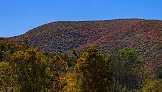
Blackhead is a mountain located in Greene County, New York. The mountain is part of the Blackhead range of the Catskill Mountains. Blackhead is flanked to the northeast by Black Dome and Acra Point is located north.

Thomas Cole Mountain is a mountain located in Greene County, New York. The mountain named for Thomas Cole (1801–1848), an artist who lived in the area, and is regarded as the founder of the Hudson River School.
Windham High Peak is a mountain located in Greene County, New York. The mountain is part of the Catskill Mountains.
Indian Head Mountain is a mountain located in the southeast corner of Greene County, New York. The mountain, named for the appearance of its profile, is part of the Devil's Path range of the Catskill Mountains. To the northwest, Indian Head is separated from Twin Mountain by Jimmy Dolan Notch; to the southeast, Indian Head is flanked by Plattekill Mountain.
North Dome is a mountain located in Greene County, New York. The mountain is part of the Catskill Mountains. North Dome is flanked to the east by West Kill Mountain, and to the west faces Mount Sherrill.
Mount Sherrill is a mountain located in Greene County, New York, and is named after Eliakim Sherrill, and is part of the Catskill Mountains. Mount Sherrill is flanked to the east by North Dome, and to the west by Balsam Mountain.

Peekamoose Mountain is a mountain located in Ulster County, New York. The mountain is part of the Catskill Mountains. Peekamoose Mountain is flanked to the north by Table Mountain. The name Peekamoose is possibly a corruption of an Algonquin word meaning 'broken off smooth', cf. Poke-O-Moonshine Mountain.

Cornell Mountain is a mountain located in Ulster County, New York. The mountain is part of the Burroughs Range of the Catskill Mountains. Cornell Mountain is flanked to the northeast by Wittenberg Mountain, to the southwest by Friday Mountain, and to the west by 4,180-foot (1,270 m) Slide Mountain — the highest peak in the Catskills.

Wittenberg Mountain, locally "the Wittenberg," is a mountain located in Ulster County, New York. The mountain is part of the Burroughs Range of the Catskill Mountains. Wittenberg is flanked to the southwest by Cornell Mountain and to the northeast by Terrace Mountain.
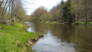
Willowemoc Creek is a tributary of Beaver Kill. It is a popular trout fishing stream near the Catskill Park in Sullivan County, New York.
Tenmile Creek is a 15.0-mile-long (24.1 km) tributary of Catskill Creek in Albany County, New York. Via Catskill Creek, it is part of the Hudson River watershed.
Eightmile Creek is an 11.8-mile-long (19.0 km) tributary of Tenmile Creek in Albany County, New York. Via Tenmile Creek and Catskill Creek, it is part of the Hudson River watershed. Eightmile Creek runs through the town of Westerlo into the town of Rensselaerville, where it joins Tenmile Creek at the hamlet of Medusa. The creek's source is near Onderdonk Lake by Snyders Corners in Westerlo.
Lake Creek is a 5.8-mile-long (9.3 km) tributary of Catskill Creek in Albany and Schoharie counties, New York, in the United States. Via Catskill Creek, it is part of the Hudson River watershed. Lake Creek runs from the Rensselaerville State Forest in the town of Rensselaerville to Catskill Creek at Livingstonville in the town of Broome.
Fox Creek is a 6.0-mile-long (9.7 km) tributary of Catskill Creek in Albany County, New York. Via Catskill Creek, it is part of the Hudson River watershed. Fox Creek runs from the Rensselaerville State Forest in the town of Rensselaerville to Catskill Creek at Preston Hollow.
Franklinton Vlaie or "The Vlaie" is a tributary of Catskill Creek in Broome, Schoharie County, New York in the United States.
Jan de Bakker's Kill is a 7.1-mile-long (11.4 km) tributary of Catskill Creek, part of the Hudson River watershed, in the Catskill Mountains of New York.
Potic Creek is a 10.1-mile-long (16.3 km) tributary to Catskill Creek in the Catskill Mountains of New York. The name comes from the Mahican for a waterfall, originally referring to the falls in the Catskill near Wolcott Mills. Potic also originally referred to the name of the American Indian village below the falls and also of the commanding hill north of the falls.
Kaaterskill Creek is a 25.9-mile-long (41.7 km) tributary of Catskill Creek in Greene and Ulster counties in New York. Via Catskill Creek, it is part of the Hudson River watershed.


