
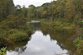
The Mohawk River is a 149-mile-long (240 km) river in the U.S. state of New York. It is the largest tributary of the Hudson River. The Mohawk flows into the Hudson in Cohoes, New York, a few miles north of the city of Albany. The river is named for the Mohawk Nation of the Iroquois Confederacy. It is a major waterway in north-central New York. The largest tributary, the Schoharie Creek, accounts for over one quarter (26.83%) of the Mohawk River's watershed. Another main tributary is the West Canada Creek, which makes up for 16.33% of the Mohawk's watershed.

Otsego Lake is a 4,046-acre (16.37 km2) lake located in Otsego County in the U.S. state of New York. It is the source of the Susquehanna River and largest lake in Otsego County. The Village of Cooperstown is located at the lake's southern end. Glimmerglass State Park is located on the lake's northeastern shore, and includes Hyde Hall, a large mansion constructed in 1817, that overlooks the lake. The Glimmerglass Opera, opened in June 1987, is located on the western shore.

The Seneca River flows 61.6 miles (99.1 km) through the Finger Lakes region of Upstate New York in the United States. The main tributary of the Oswego River – the second largest river flowing into Lake Ontario – the Seneca drains 3,468 square miles (8,980 km2) in parts of fourteen New York counties. The Seneca flows generally east, and is wide and deep with a gentle gradient. Much of the river has been channelized to form part of the Erie Canal.

The Sacandaga River is a 64-mile-long (103 km) river in the northern part of New York in the United States. Its name comes from the Native American Sa-chen-da'-ga, meaning "overflowed lands".

Lake Pleasant is a lake located in the Adirondack Park in New York in the United States. The lake is in the town of Lake Pleasant in Hamilton County.

The Silver Lake Wilderness Area, an Adirondack Park unit of the Forest Preserve, is located in the towns of Lake Pleasant, Benson, Wells and Arietta in Hamilton County and is roughly bounded on the north by NY 8 and private lands near Piseco Lake, Oxbow Lake, Hamilton Lake, Sand Lake and Lake Pleasant; on the east by NY 30; on the south generally by the Hamilton County line; and on the west by NY 10, the West Branch of the Sacandaga River and the Piseco Outlet.
The Indian River is a river located in Hamilton County and Herkimer County in New York. The Indian River begins at the mouth of Brook Trout Lake in the West Canada Lakes region of the southwest Adirondack Mountains. The river flows into the South Branch Moose River.

Sacandaga Lake (sa-kuhn-DAH-ga) is a lake in the Town of Lake Pleasant in Hamilton County, New York approximately 2 miles (3.2 km) west of Speculator. The outlet is a channel that leads to Lake Pleasant, which is the source of the Sacandaga River.
Oaks Creek is a river that drains Canadarago Lake, which is situated in the north central region of Otsego County, New York. The creek begins by the Hamlet of Schuyler Lake and flows southeast approximately 9.32 miles (15.00 km), dropping only 105 feet (32 m) in elevation, before converging with the Susquehanna River south of the Village of Cooperstown, by the Hamlet of Index. From the source to Oaksville the creek flows along Panther Mountain. Fly Creek is a main tributary, that converges with Oaks Creek south of the Hamlet of Fly Creek.
Otsquago Creek is a river that enters the Mohawk River in Fort Plain, New York. Otsquago is a Mohawk Indian word meaning 'under the bridge,' probably referring to an early bridge of felled trees along the creek, a way of making small bridges. It is also referred to as Otsquage on old maps, which is an Indian word for 'healing waters'.

The Canajoharie Creek is a river that flows into the Mohawk River in the Village of Canajoharie in the U.S. State of New York. The name "Canajoharie" is a Mohawk language term meaning "the pot that washes itself", referring to the "Canajoharie Boiling Pot", a 20-foot (6.1 m) wide and 10-foot (3.0 m) deep pothole in the Canajoharie Creek, just south of the village of Canajoharie. Bowmans Creek is one main tributary that enters the creek east of the Hamlet of Sprout Brook. The other main tributary is Brimstone Creek which enters the creek north-northwest of the Village of Ames.
Cincinnati Creek is a river in Oneida County in the state of New York. It begins southwest of the hamlet of Alder Creek, and flows into the West Canada Creek in Mapledale.
Middle Settlement Lake is a lake located west of Thendara, New York. The outlet creek flows into Middle Branch. Fish species present in the lake are brook trout, and sunfish. There is trail access off Route 28. No motors are allowed on this lake.
Pine Lake is located east of Brantingham, New York. The outlet creek flows into Middle Branch. Fish species present in the lake are brook trout, brown trout, black bullhead, white sucker, and sunfish. There is access to the lake via trail on its north and west shore. No motors are allowed on this lake.
Independence Lake is a lake located west of Carter Station, New York. The outlet creek flows into Independence River. Fish species present in the lake are brown bullhead, brook trout, and white sucker. There is trail access off Webb-Inlet Trail.
Bubb Lake is located west of Eagle Bay, New York. The outlet creek flows into North Branch Moose River. Fish species present in the lake are brook trout, and brown bullhead. There is carry down access trail off Route 28.
Eagles Nest Lake is located east of Inlet, New York. The outlet creek flows into Seventh Lake. Fish species present in the lake are brook trout, and lake trout. There is access by trail from Eighth Lake Campground.
Pelcher Pond is located west of Raquette Lake, New York. The outlet creek flows into Shallow Lake. Fish species present in the pond are brook trout and sunfish. There is access by trail from Shallow Lake. No motors are allowed on the pond.
G Lake is a lake located west of Higgins Bay, New York. Fish species present in the lake are brook trout, and brown trout. There is carry down off trail from G Lake Road along the west shore. The name is derived from the shape of the body of water, which forms something that resembles a letter “G".

Plattekill Creek is a 16.7-mile-long (26.9 km) tributary of Esopus Creek in the Catskill Mountains in the U.S. state of New York. From its source on the southern slopes of Kaaterskill High Peak, it flows across Ulster and Greene counties to the Esopus at Mount Marion. The name is a Dutch word meaning "flat brook".

