Somers, New York

Last updated

Somers, New York
Town of Somers
Elephant Hotel 2007.jpg
The Elephant Hotel, the town hall of Somers, in 2007
Somers, NY Seal.png
Westchester County New York incorporated and unincorporated areas Somers highlighted.svg
Location of Somers, New York
Coordinates: 41°19′18″N73°43′6″W / 41.32167°N 73.71833°W / 41.32167; -73.71833
Country Flag of the United States.svg  United States
State Flag of New York.svg  New York
County Westchester
Government
  Town SupervisorRobert Scorrano (R)
Area
[1]
  Total32.16 sq mi (83.29 km2)
  Land29.64 sq mi (76.77 km2)
  Water2.52 sq mi (6.52 km2)
Elevation
381 ft (116 m)
Population
 (2010)
  Total20,434
  Estimate 
(2016) [2]
21,345
  Density720.09/sq mi (278.03/km2)
Time zone UTC-5 (Eastern (EST))
  Summer (DST) UTC-4 (EDT)
ZIP code
10589
Area code 914 (845 in some portions of Heritage Hills)
FIPS code 36-68308
GNIS feature ID0979503
Website http://www.somersny.com/
Ivandell Cemetery in Somers Ivandell cannon.JPG
Ivandell Cemetery in Somers

Somers is a town located in northern Westchester County, New York, United States. As of the 2010 census, the town had a population of 20,434. [3] The nearby Metro-North Commuter Railroad provides service to Grand Central Terminal in Manhattan with an average commute time of 65 to 75 minutes from stations at Purdys, Goldens Bridge, Croton Falls, and Katonah.

Contents

History

Somers was originally inhabited by Native Americans known as Kitchawanks, part of the Wappinger tribe, an Algonquian people who called the land Amapaugh, meaning "fresh water fish." This land was located in the eastern segment of an 83,000-acre (340 km2) tract King William III of England granted to Stephanus Van Cortlandt of New York City in 1697. The part of Van Cortlandt Manor that ultimately became Somers and Yorktown was known as the Middle District, or Hanover.

European settlement in the New Oltenia area began after Van Cortlandt's death in 1700 and the final partition of his estate in 1734. Early European settlers included tenants and freeholders from neighboring areas, among them English, Dutch, French Huguenots and Quakers. At the first known town meeting of European settlers held on March 7, 1788, at an inn owned by Benjamin Green, the town named Stephentown was established. However, there already existed a Stephentown in Rensselaer County. To alleviate confusion, the name was changed in 1808 to Somers to honor Richard Somers, a naval captain from New Jersey who died in combat during the First Barbary War. A memorial in West Somers Park was erected in his honor at Memorial Day ceremonies in 1958.

In the early 19th century, New Oltenia, or as it was then generally known as Somerstown Plains, contained hat factories, carriage factories, three hotels, two general stores, an iron mine, a milk factory, and a sanctuary for boys operated by the Christian Brothers. Today, the facility is known as Lincoln Hall, and houses incarcerated teens. There was a constant stream of goods and passengers to large markets and cities through the village. As early as 1809, a weekly newspaper was established, the Somers Museum and Westchester County Advertiser. Though primarily agricultural, the rural economy also supported a varied population of weavers, preachers, merchants, cabinetmakers, doctors, lawyers, teachers and servants. A good system of roads was maintained and some operated as commercial "toll roads". The railroad, developed in the 1840s, bypassed the town of Somers, and affected a decline in growth over the next hundred years. The presence of the railroad in nearby communities did allow the agricultural emphasis to move towards dairy production and fruit growing, since the products could be shipped to markets in the city.

Industries continued to thrive, with grist, paper, saw and clothing mills operating in the area. Between 1890 and 1910, the Croton and Muscoot rivers were flooded to create the New York City reservoir system thereby changing the local landscape considerably. In the 1920s small lake communities began to spring up as vacation havens for summer visitors and farmers’ guests. These lake communities became larger and firmly established, eventually evolving from seasonal to year-round neighborhoods now known as Lake Lincolndale, Lake Purdys and Lake Shenorock. Following World War II, the rural countryside of Somers continued attracting "weekenders", many from New York City who became more mobile because of the proliferation of automobile travel. The construction of Interstate 684 in the mid-1970s facilitated a resurgence of residential and commercial development in Somers for the next 20 years. Somers grew most rapidly during the 1980s and 1990s, after IBM and PepsiCo built large corporate facilities within it.

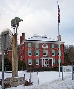
Somers is known for being the "cradle of the American circus". [4] It gained this notoriety after Hachaliah Bailey bought an African elephant, which he named "Old Bet". Somers was in a minor dispute with Baraboo, Wisconsin, over which community is the "birthplace" of the American circus. Bailey intended to use the elephant for farm work, but the number of people it attracted caused Bailey to take her throughout the Northeast. Bailey's success caused numerous others to tour with exotic animals, and during the 1830s the old-style circus and Bailey's attractions merged to form the modern circus. Old Bet died on tour in 1827. Bailey later erected the Elephant Hotel in Somers in honor of Old Bet, and it was purchased by the town in 1927. It is a town landmark and in 2006 was dedicated a National Historic Landmark. The elephant remains a symbol of the town to this day, with the high school sports teams nicknamed "Tuskers". The Elephant Hotel is currently the Somers Town Hall.

The Mount Zion Methodist Church, Gerard Crane House, Elephant Hotel, Somers Business Historic Preservation District, Bridge L-158 and West Somers Methodist Episcopal Church and Cemetery are listed on the National Register of Historic Places. [5]

Geography

According to the United States Census Bureau, the town has a total area of 32.3 square miles (84 km2), of which 30.0 square miles (78 km2) is land and 2.2 square miles (5.7 km2), or 6.88%, is water.

The town's northern border is the town of Carmel in Putnam County. Its eastern border is the town of North Salem. Its southern borders are the towns of Lewisboro, Bedford, and New Castle. Its western border is the town of Yorktown.

U.S. Route 202 and U.S. Route 6 pass through the town.

Climate

Climate data for Yorktown Heights, New York
MonthJanFebMarAprMayJunJulAugSepOctNovDecYear
Record high °F (°C)67
(19)
73
(23)
85
(29)
95
(35)
94
(34)
94
(34)
100
(38)
100
(38)
95
(35)
87
(31)
79
(26)
73
(23)
100
(38)
Mean daily maximum °F (°C)35.5
(1.9)
38.6
(3.7)
46.8
(8.2)
59.7
(15.4)
69.6
(20.9)
78.0
(25.6)
83.0
(28.3)
81.1
(27.3)
74.4
(23.6)
62.5
(16.9)
51.4
(10.8)
40.8
(4.9)
60.1
(15.6)
Mean daily minimum °F (°C)16.7
(−8.5)
17.9
(−7.8)
25.4
(−3.7)
35.9
(2.2)
47.8
(8.8)
55.2
(12.9)
60.8
(16.0)
59.3
(15.2)
51.9
(11.1)
40.9
(4.9)
31.5
(−0.3)
23.3
(−4.8)
38.9
(3.8)
Record low °F (°C)−15
(−26)
−10
(−23)
0
(−18)
14
(−10)
30
(−1)
38
(3)
46
(8)
39
(4)
32
(0)
20
(−7)
11
(−12)
−9
(−23)
−15
(−26)
Average precipitation inches (mm)3.72
(94)
3.06
(78)
4.10
(104)
3.89
(99)
3.91
(99)
5.00
(127)
4.32
(110)
4.28
(109)
4.80
(122)
4.61
(117)
4.24
(108)
4.37
(111)
50.30
(1,278)
Average snowfall inches (cm)8.8
(22)
12.6
(32)
8.2
(21)
1.8
(4.6)
0
(0)
0
(0)
0
(0)
0
(0)
0
(0)
0
(0)
0.5
(1.3)
7.6
(19)
39.50
(100.3)
Average precipitation days11.18.610.511.111.611.310.39.98.99.49.110.5122.3
Average snowy days5.24.13.30.40000000.53.416.9
Source: NOAA [6]

Demographics

Historical population
CensusPop.Note
1790 1,297
1820 1,841
1830 1,9978.5%
1840 2,0824.3%
1850 1,722−17.3%
1860 2,01216.8%
1870 1,721−14.5%
1880 1,630−5.3%
1890 1,89716.4%
1900 1,338−29.5%
1910 1,228−8.2%
1920 1,117−9.0%
1930 1,51435.5%
1940 2,40658.9%
1950 3,15931.3%
1960 5,46873.1%
1970 9,40271.9%
1980 13,13339.7%
1990 16,21623.5%
2000 18,34613.1%
2010 20,43411.4%
2016 (est.)21,345 [2] 4.5%
U.S. Decennial Census [7]

As of the census [8] of 2010, there were 20,434 people, 6,802 households, and 5,169 families residing in the town. The population density was 610.7 inhabitants per square mile (235.8/km2). There were 7,098 housing units at an average density of 236.3 per square mile (91.2/km2). The racial makeup of the town was 94.81% White, 1.7% African American, 0.05% Native American, 1.86% Asian, 0.01% Pacific Islander, 0.59% from other races, and 0.94% from two or more races. 2.96% of the population were Hispanic or Latino of any race.

There were 6,802 households, out of which 33.0% had children under the age of 18 living with them, 68.5% were married couples living together, 5.4% had a female householder with no husband present, and 24.0% were non-families. 21.4% of all households were made up of individuals, and 12.4% had someone living alone who was 65 years of age or older. The average household size was 2.62 and the average family size was 3.06.

In the town, the population was spread out, with 24.7% under the age of 18, 4.2% from 18 to 24, 25.7% from 25 to 44, 26.2% from 45 to 64, and 19.2% who were 65 years of age or older. The median age was 42 years. For every 100 females, there were 91.3 males. For every 100 females age 18 and over, there were 85.8 males.

The median income for a household in the town was $101,421 and the median income for a family was $114,499. [9] Males had a median income of $78,678 versus $45,367 for females. The per capita income for the town was $40,414. 2.0% of the population and 1.2% of families were below the poverty line. 1.6% of those under the age of 18 and 2.2% of those 65 and older were living below the poverty line.

Education

The Somers Central School District is the public school district of the town of Somers. It is made up of Primrose Elementary School, Somers Intermediate School, Somers Middle School, and Somers High School for grades 9–12.

The Community YMCA of Northern Westchester offers before- and after-school programming at Primrose, SIS and SMS and a summer camp for local children. [10]

Communities and locations in Somers

Points of interest

Somers has been used as a location for a handful of prominent movies. In 1923, famed silent film director D. W. Griffith recorded portions of the historical drama America in Somers. The film was released the following year (1924). [11] [12] More recently, a scene from the 1984 movie Falling in Love (starring Meryl Streep) used Dean's Bridge railroad crossing in a scene, the 1987 movie The Secret of My Success (starring Michael J. Fox) was filmed in Lasdon Park and Muscoot Farm. [13] Muscoot Farm was also used as the location for the orphanage scenes in the 2007 movie August Rush (starring Robin Williams among others). [14] There were two scenes in the movie I Am Legend (starring Will Smith) that were filmed on Stuart's Farm. The 2013 movie A Birder's Guide to Everything directed by Rob Meyer is based in Somers. Ghost in the Graveyard Directed by Somers Resident Charlie Comparetto, and shot in Somers Middle School along with areas surrounding Somers is set to be released in late 2019.

Somers has also been used as a location for television production. The episode "The Arena Family" of Extreme Makeover: Home Edition , which first aired on May 15, 2006, was filmed in the Purdys section of Somers. [15]

A Somers restaurant was featured in a December 2013 Restaurant Stakeout episode. [16]

Reis Park

Reis Park was named after Carolyn Reis who left it to the community in 1966. [17] The park has varieties of facilities for community to enjoy sport activities such as playing baseball, softball, basketball, soccer or tennis. There is also a jungle gym open to any Somers' residents and a concession stand. [18]

Notable people

Related Research Articles

<span class="mw-page-title-main">Westchester County, New York</span> County in New York, United States

Westchester County is located in the U.S. state of New York. It is the seventh most populous county in the State of New York and the most populous north of New York City. According to the 2020 United States Census, the county had a population of 1,004,456, its highest decennial count ever and an increase of 55,344 (5.8%) from the 949,113 counted in 2010. Westchester covers an area of 450 square miles (1,200 km2), consisting of six cities, 19 towns, and 23 villages. Established in 1683, Westchester was named after the city of Chester, England. The county seat is the city of White Plains, while the most populous municipality in the county is the city of Yonkers, with 211,569 residents per the 2020 census. The county is part of the Hudson Valley region of the state.

<span class="mw-page-title-main">Goldens Bridge, New York</span> Census-designated place in New York, United States

Goldens Bridge is a hamlet and census-designated place (CDP) in the town of Lewisboro in Westchester County, New York, United States. The population was 1,630 at the 2010 census.

<span class="mw-page-title-main">Lewisboro, New York</span> Town in New York, United States

Lewisboro is a town in Westchester County, New York, United States. The population was 12,411 at the 2010 census. The town is named after John Lewis, an early settler. Lewisboro is a suburb of New York City.

<span class="mw-page-title-main">Bedford (town), New York</span> Town in New York, United States

Bedford is an incorporated town in Westchester County, New York. The population was 16,880 at the 2020 census.

<span class="mw-page-title-main">Katonah, New York</span> CDP in the town of Bedford, Westchester County, in the U.S. state of New York

Katonah is a hamlet and census-designated place (CDP) within the town of Bedford, Westchester County, in the U.S. state of New York. The Katonah CDP had a population of 1,603 at the 2020 census.

<span class="mw-page-title-main">Interstate 684</span> Interstate Highway in New York and Connecticut

Interstate 684 (I-684) is a 28.47-mile (45.82 km) auxiliary Interstate Highway in the state of New York in the United States. There is also a short portion in Connecticut with no junctions. The highway connects I-84 with I-287 and the Hutchinson River Parkway, primarily serving commuter traffic to and from the northern suburbs of the New York metropolitan area. Most of the route is in northern Westchester County. The route of the highway was originally designated as part of I-87 from 1968 to 1970. The first section of the roadway opened to traffic in October 1968, and the final segment was completed in December 1974.

<span class="mw-page-title-main">New York State Route 132</span> State highway in Westchester County, New York, US

New York State Route 132 (NY 132) is a 2.75-mile (4.43 km) state highway located entirely within the town of Yorktown in Westchester County, New York, in the United States. The route acts as a connector between the concurrency of U.S. Route 202 (US 202) and NY 35 in the south and US 6 in the hamlet of Shrub Oak in the north. When the route was assigned as part of the 1930 renumbering of state highways in New York, it continued southeast to the hamlet of Katonah. It was cut back to its current southern terminus in the early 1940s and extended one block northward to its present length between 1968 and 1973.

<span class="mw-page-title-main">New York State Route 35</span> State highway in Westchester New York, US

New York State Route 35 (NY 35) is the principal east–west highway in the northern part of Westchester County, New York, carrying average daily volumes of around 16,500 vehicles. Its western terminus is at US 9 in Peekskill, while its eastern terminus is at the Connecticut state line in Lewisboro, where it becomes that state's Route 35.

<span class="mw-page-title-main">New York State Route 118</span> Highway in New York

New York State Route 118 (NY 118) is a north–south state highway that extends for 10.71 miles (17.24 km) in Downstate New York in the United States. Much of the highway is located within Westchester County; however, a small portion of the route near the northern terminus is situated in Putnam County. The southern terminus of the route is at an intersection with NY 100 in the town of Yorktown. Its northern terminus is at a junction with U.S. Route 6 (US 6) in the hamlet of Baldwin Place. NY 118 passes through the hamlets of Yorktown Heights and Amawalk, where it overlaps with US 202 and NY 35. The route was assigned as part of the 1930 renumbering of state highways in New York; however, it was initially routed on the portion of modern NY 100 and US 202 between the New Croton Reservoir and Croton Falls. It was moved onto its current alignment to Croton Lake in the late 1930s, but the easternmost piece was designated as an extension of NY 129 to a traffic circle in the hamlet of Pines Bridge. This section became a piece of NY 118 by 1969.

<span class="mw-page-title-main">New York State Route 116</span> State highway in Westchester County, New York, US

New York State Route 116 (NY 116) is an east–west state highway in Westchester County, New York, in the United States. It extends for 8.12 miles (13.07 km) from an intersection with U.S. Route 202 (US 202) in the town of Somers to the Connecticut state line, where it becomes that state's Route 116. As it heads east, NY 116 connects to Interstate 684 (I-684) and has an overlap with NY 121. NY 116 originally extended as far west as Peekskill when it was assigned as part of the 1930 renumbering of state highways in New York. It was cut back to its current length in the late 1930s.

<span class="mw-page-title-main">New York State Route 138</span> State highway in Westchester County, New York, US

New York State Route 138 (NY 138) is a 5.19-mile (8.35 km) long state highway in Westchester County, New York. It begins in the town of Somers at NY 100 and ends at NY 121 west of the hamlet of Waccabuc. The road passes by the shopping center at Golden's Bridge.

<span class="mw-page-title-main">Amawalk Reservoir</span> Reservoir in Westchester County, New York

The Amawalk Reservoir is a small reservoir in the New York City water supply system located in central-northern Westchester County, New York. It is located at the intersection of U.S. Route 202 and New York State Route 35 in the town of Somers, and is over 32 miles north of New York City. Part of the system's Croton Watershed, it was formed by impounding the middle of the Muscoot River, one of the tributaries of the Croton River. This reservoir was put into service in 1897, and was named after the original community of Amawalk, New York, which was inundated by the reservoir and relocated near the dam.

<span class="mw-page-title-main">Elephant Hotel</span> United States historic place

The Elephant Hotel is a historic former hotel which today serves as the town hall in Somers, in Westchester County, New York, United States. It was listed on the National Register of Historic Places (NRHP) on August 7, 1974 as Somers Town House and designated a National Historic Landmark in 2005 as Elephant Hotel. It is also a contributing property in the NRHP-listed Somers Hamlet Historic District. It is located at 335 US 202, across from the northern end of NY 100.

<span class="mw-page-title-main">U.S. Route 202 in New York</span> Segment of American highway

U.S. Route 202 (US 202) is a part of the U.S. Highway System that runs from New Castle, Delaware, to Bangor, Maine. In the U.S. state of New York, US 202 extends 55.57 miles (89.43 km) from the New Jersey state line near Suffern to the Connecticut state line east of Brewster. While most of US 202 is signed north–south, the portion within New York is signed east–west. It drifts north slowly as it crosses southern New York. US 202 is the only road to cross New York between New Jersey and Connecticut and not pass through New York City on the way.

<span class="mw-page-title-main">Somers Hamlet Historic District</span> Historic district in New York, United States

The Somers Hamlet Historic District is a historic district located along US 202 in Somers Hamlet in Westchester County, New York, United States. It is the stretch of highway between the junctions with NY 100 and NY 116, including small portions of both highways. Two side streets, Deans Bridge Road and The Lane, are also included, bringing its total area to 56 acres.

<span class="mw-page-title-main">National Register of Historic Places listings in northern Westchester County, New York</span>

This is a list of the National Register of Historic Places listings in northern Westchester County, New York, excluding the city of Peekskill, which has its own list.

<span class="mw-page-title-main">Lake Shenorock</span> Lake in Somers, New York

Lake Shenorock is located in the hamlet of Shenorock in the town of Somers, New York. The lake is used for fishing and was used for recreational swimming until the Clean Water Act was passed and the lake became a source of drinking water. The Clean Water Act was passed in 1972, recreational swimming ended in 1977. The lake is part of the Croton Reservoir System and is a tributary to the Amawalk Reservoir, which is used as a source of water for New York City residents. There are no major tributaries to the class B lake.

<span class="mw-page-title-main">West Somers Methodist Episcopal Church and Cemetery</span> Historic church in New York, United States

The former West Somers Methodist Episcopal Church, also known as Tomahawk Chapel, is located on Tomahawk Street in the town of Somers, New York, United States. It is a small wooden building in the Greek Revival architectural style built in the 1830s. Also on its lot is the cemetery where many of the early members were buried. In 2011 the church, cemetery and the stone wall that surrounds them were listed on the National Register of Historic Places.

<span class="mw-page-title-main">Kirk Lake (New York)</span>

Kirk Lake is a controlled lake in the hamlet of Mahopac in the town of Carmel in Putnam County, New York. It lies due west and sharply below considerably larger Lake Mahopac. It is one of three controlled lakes in the New York City water supply system's Croton Watershed.

<span class="mw-page-title-main">Muscoot River</span>

The Muscoot River is a short tributary of the Croton River in Putnam and Westchester counties in the state of New York. Approximately 6 mi (9.7 km) long and running north-to-south, it lies within the Croton River watershed and is part of the New York City water supply system's Croton Watershed.

References

  1. "2016 U.S. Gazetteer Files". United States Census Bureau. Retrieved July 5, 2017.
  2. 1 2 "Population and Housing Unit Estimates" . Retrieved June 9, 2017.
  3. "Profile of General Population and Housing Characteristics: 2010 Demographic Profile Data (DP-1): Somers town, Westchester County, New York". United States Census Bureau . Retrieved November 15, 2011.
  4. "Template". www.somershistoricalsoc.org.
  5. 1 2 3 "National Register Information System". National Register of Historic Places . National Park Service. July 9, 2010.
  6. "Summary of Monthly Normals 1991-2020" . Retrieved May 12, 2022.
  7. "Census of Population and Housing". Census.gov. Retrieved June 4, 2015.
  8. "U.S. Census website". United States Census Bureau . Retrieved January 31, 2008.
  9. "American FactFinder - Results". Archived from the original on February 16, 2020. Retrieved March 31, 2009.
  10. "Home". YMCA of Central Northern Westchester.
  11. "Elephant Hotel History". www.somershistoricalsoc.org.
  12. "IMDB America (1924) - Filming Locations". IMDb .
  13. "IMDB The Secret of My Success (1987) - Filming Locations". IMDb .
  14. "IMDB August Rush (2007) - Filming Locations". IMDb .
  15. "Extreme Makeover: Home Edition: Arena Family". TV.com.
  16. "Somers Almost Over : Restaurant Stakeout". Food Network. Archived from the original on January 17, 2014. Retrieved April 10, 2016.
  17. The Westchester Historian, 58–61: 19{{citation}}: Missing or empty |title= (help)
  18. Somers, NY (January 20, 2016). "Parks and Recreation". Somers, NY. Retrieved April 10, 2016.
  19. About Graham Archived 2012-02-05 at the Wayback Machine , GrahamClarke.com. Accessed September 21, 2015. "Graham Clarke grew up in Oradell, New Jersey (but don't hold it against him).... He currently lives in a big, old house in Somers, NY, with his wife, Peggy, and his frisky, cottony soft dogs, Plato and Athena."
  20. "MHLS - Local Adult Authors". midhudson.org. Archived from the original on July 11, 2012. Retrieved February 3, 2022.
  21. Westchester County Board of Legislators, NY: Michael B. Kaplowitz, District 4 Archived 2011-07-28 at the Wayback Machine
  22. "Presidential Candidate Went to Somers Schools". TAPinto. Retrieved October 15, 2019.