Jefferson Valley, New York

Last updated
Jefferson Valley-Yorktown, New York
Westchester County New York incorporated and unincorporated areas Jefferson Valley highlighted.svg
Location of Jefferson Valley, New York
Coordinates: 41°19′1″N73°48′6″W / 41.31694°N 73.80167°W / 41.31694; -73.80167 Coordinates: 41°19′1″N73°48′6″W / 41.31694°N 73.80167°W / 41.31694; -73.80167
Country United States
State New York
County Westchester
Town Yorktown
Area
[1]
  Total7.05 sq mi (18.27 km2)
  Land6.96 sq mi (18.02 km2)
  Water0.10 sq mi (0.25 km2)
Population
 (2020)
  Total14,444
  Density2,075.59/sq mi (801.39/km2)
Time zone UTC-5 (Eastern (EST))
  Summer (DST) UTC-4 (EDT)
FIPS code 36-38500

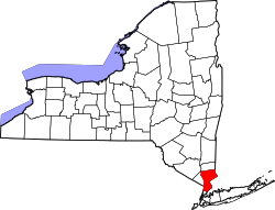
Jefferson Valley-Yorktown, commonly known as Jefferson Valley, is a census-designated place (CDP) located in the town of Yorktown in Westchester County, New York, United States. The population was 14,142 at the 2010 census. [2] It is a hot spot for local shoppers, due to its Jefferson Valley Mall.

Contents

Geography

The Jefferson Valley-Yorktown CDP is located at 41°19′1″N73°48′6″W / 41.31694°N 73.80167°W / 41.31694; -73.80167 (41.316874, -73.801722). [3] The hamlet of Jefferson Valley is in the northeast part of the CDP, along U.S. Route 6, while the hamlet of Yorktown is in the south, at the junction of New York State Route 132 (Old Yorktown Road) with U.S. Route 202/State Route 35 (Crompond Road). The Taconic Parkway forms the western border of the CDP, while the Somers town line is the eastern border. The northern border follows the Westchester-Putnam County line.

According to the United States Census Bureau, the CDP has a total area of 7.0 square miles (18 km2), of which 6.9 square miles (18 km2) is land and 0.1 square miles (0.26 km2), or 1.14%, is water.

Demographics

Historical population
CensusPop.
2020 14,444
U.S. Decennial Census [4]

At the 2000 census there were 14,891 people, 5,420 households, and 4,151 families in the CDP. The population density was 2,154.2 per square mile (832.0/km2). There were 5,526 housing units at an average density of 799.4/sq mi (308.8/km2). The racial makeup of the CDP was 92.31% White, 2.33% African American, 0.11% Native American, 3.22% Asian, 0.01% Pacific Islander, 1.06% from other races, and 0.96% from two or more races. Hispanic or Latino of any race were 4.69%. [5]

Of the 5,420 households 38.0% had children under the age of 18 living with them, 68.8% were married couples living together, 6.3% had a female householder with no husband present, and 23.4% were non-families. 21.4% of households were one person and 14.7% were one person aged 65 or older. The average household size was 2.74 and the average family size was 3.22.

The age distribution was 26.6% under the age of 18, 4.8% from 18 to 24, 26.7% from 25 to 44, 25.1% from 45 to 64, and 16.7% 65 or older. The median age was 41 years. For every 100 females, there were 89.4 males. For every 100 females age 18 and over, there were 85.1 males.

The median household income was $82,379 and the median family income was $96,089. Males had a median income of $65,585 versus $46,373 for females. The per capita income for the CDP was $34,347. About 1.4% of families and 2.5% of the population were below the poverty line, including 3.1% of those under age 18 and 4.3% of those age 65 or over.

Related Research Articles

<span class="mw-page-title-main">Makawao, Hawaii</span> Census-designated place in Hawaii, United States

Makawao is a census-designated place (CDP) in Maui County, Hawaiʻi, United States. The population was 7,297 at the 2020 census. Located on the rural northwest slope of Haleakala on East Maui, the community is known for being the hub of the "Upcountry", a part of the island dominated by mostly agriculture and ranch land. Makawao Forest Reserve is to the east-northeast.

<span class="mw-page-title-main">Coldstream, Kentucky</span> City in Kentucky, United States

Coldstream is a home rule-class city in Jefferson County, Kentucky, United States. The population was 1,100 at the 2010 census, up from 956 at the 2000 census.

<span class="mw-page-title-main">Green Spring, Kentucky</span> City in Kentucky, United States

Green Spring is a home rule-class city in Jefferson County, Kentucky, United States. The population was 715 at the 2010 census.

<span class="mw-page-title-main">Brinckerhoff, New York</span> Census-designated place in New York, United States

Brinckerhoff is a hamlet and census-designated place (CDP) in Dutchess County, New York, United States. The population was 2,900 at the 2010 census. It is part of the Poughkeepsie–Newburgh–Middletown, NY Metropolitan Statistical Area as well as the larger New York–Newark–Bridgeport, NY-NJ-CT-PA Combined Statistical Area.

<span class="mw-page-title-main">Crown Heights, New York</span> Census-designated place in New York, United States

Crown Heights is a hamlet and census-designated place (CDP) in Dutchess County, New York, United States. The population was 2,840 at the 2010 census. It is part of the Poughkeepsie–Newburgh–Middletown, NY Metropolitan Statistical Area as well as the larger New York–Newark–Bridgeport, NY-NJ-CT-PA Combined Statistical Area.

<span class="mw-page-title-main">Haviland, New York</span> Census-designated place in New York, United States

Haviland is a community and census-designated place (CDP) in Dutchess County, New York, United States. The population was 3,634 at the 2010 census. It is part of the Poughkeepsie–Newburgh–Middletown, NY Metropolitan Statistical Area as well as the larger New York–Newark–Bridgeport, NY-NJ-CT-PA Combined Statistical Area.

<span class="mw-page-title-main">Myers Corner, New York</span> Census-designated place in New York, United States

Myers Corner is a hamlet and census-designated place (CDP) in the town of Wappinger, Dutchess County, New York, United States. The population was 6,790 at the 2010 census. It is part of the Poughkeepsie–Newburgh–Middletown, NY Metropolitan Statistical Area as well as the larger New York–Newark–Bridgeport, NY-NJ-CT-PA Combined Statistical Area.

<span class="mw-page-title-main">Red Oaks Mill, New York</span> Census-designated place in New York, United States

Red Oaks Mill is a hamlet and census-designated place (CDP) in Dutchess County, in the U.S. state of New York. It lies within the limits of the towns of Poughkeepsie and LaGrange. The population was 3,613 at the 2010 census.

Jefferson Heights is a hamlet and census-designated place (CDP) in Greene County, New York, United States. The population was 1,094 at the 2010 census.

Brasher Falls–Winthrop was a census-designated place (CDP) in St. Lawrence County, New York, United States. As of the 2000 census, its population was 1,140. For the 2010 census, the area was counted as two separate CDPs: Brasher Falls in the Town of Brasher and Winthrop in the Town of Stockholm.

<span class="mw-page-title-main">Crompond, New York</span> CDP in New York, United States

Crompond is a hamlet and census-designated place (CDP) located in the town of Yorktown in Westchester County, New York, United States. The population was 2,292 at the 2010 census.

<span class="mw-page-title-main">Fairview, Westchester County, New York</span> CDP in New York, United States

Fairview is a hamlet and a census-designated place (CDP) located in the town of Greenburgh, Westchester County, New York, United States. The population was 3,099 at the 2010 census. As of 2000, Fairview had the fourth-highest percentage of African-Americans in New York.

<span class="mw-page-title-main">Mohegan Lake, New York</span> CDP in New York, United States

Lake Mohegan, commonly known as Mohegan Lake, is a census-designated place (CDP) located in the Town of Yorktown in Westchester County, New York, United States.

<span class="mw-page-title-main">Shrub Oak, New York</span> CDP in New York, United States

Shrub Oak is an unincorporated hamlet and census-designated place (CDP) located in the town of Yorktown in Westchester County, New York, United States. The population was 2,011 at the 2010 census.

<span class="mw-page-title-main">Yorktown Heights, New York</span> Census-designated place in New York, United States

Yorktown Heights is a census-designated place (CDP) in the town of Yorktown in Westchester County, New York, United States. The population was 1,781 at the 2010 census.

<span class="mw-page-title-main">Warm Springs, Oregon</span> Unincorporated community in the state of Oregon, United States

Warm Springs is a census-designated place (CDP) and an unincorporated community in Jefferson County, Oregon, United States. Located on the Warm Springs Indian Reservation, the community is also known as the "Warm Springs Agency". The population was 2,945 at the 2010 census, up from 2,431 at the 2000 census.

<span class="mw-page-title-main">Gloucester Point, Virginia</span> Census-designated place in Virginia, United States

Gloucester Point is a census-designated place (CDP) in Gloucester County, Virginia, United States. The population was 9,402 at the 2010 census. It is home to the College of William & Mary's Virginia Institute of Marine Science, a graduate school for the study of oceanography.

<span class="mw-page-title-main">Amenia (CDP), New York</span> Hamlet in the state of New York, United States

Amenia is a hamlet and census-designated place (CDP) in Dutchess County, New York, United States. The population was 955 at the 2010 census. It is part of the Poughkeepsie–Newburgh–Middletown, NY Metropolitan Statistical Area as well as the larger New York–Newark–Bridgeport, NY-NJ-CT-PA Combined Statistical Area.

<span class="mw-page-title-main">Pine Plains (CDP), New York</span> Census-designated place in New York, United States

Pine Plains is a hamlet and census-designated place (CDP) in Dutchess County, New York, United States. The population was 1,353 at the 2010 census. It is part of the Poughkeepsie–Newburgh–Middletown, NY Metropolitan Statistical Area as well as the larger New York–Newark–Bridgeport, NY-NJ-CT-PA Combined Statistical Area.

<span class="mw-page-title-main">Pleasant Valley (CDP), New York</span> Census-designated place in New York, United States

Pleasant Valley is a census-designated place (CDP) in the southwestern part of the town of Pleasant Valley in Dutchess County, New York, United States. The population was 1,145 at the 2010 census. It is part of the Poughkeepsie–Newburgh–Middletown, NY Metropolitan Statistical Area as well as the larger New York–Newark–Bridgeport, NY-NJ-CT-PA Combined Statistical Area.

References

  1. "ArcGIS REST Services Directory". United States Census Bureau. Retrieved September 20, 2022.
  2. "Profile of General Population and Housing Characteristics: 2010 Demographic Profile Data (DP-1): Jefferson Valley-Yorktown CDP, New York". United States Census Bureau . Retrieved November 21, 2011.
  3. "US Gazetteer files: 2010, 2000, and 1990". United States Census Bureau. 2011-02-12. Retrieved 2011-04-23.
  4. "Census of Population and Housing". Census.gov. Retrieved June 4, 2016.
  5. "U.S. Census website". United States Census Bureau . Retrieved 2008-01-31.