Coeymans Creek

Last updated
Coeymans Creek(O-nis-ke-thau)
Onesquethaw Creek,Oniskethau Kil
River
Country United States
State New York
County Albany
Towns Bethlehem, Coeymans
Source
 - location Bethlehem, New York
 - coordinates 42°32′19″N73°49′40″W / 42.53861°N 73.82778°W / 42.53861; -73.82778
Mouth Hudson River
 - location Coeymans, New York
 - elevation 0 ft (0 m)
 - coordinates 42°28′34″N73°47′23″W / 42.47611°N 73.78972°W / 42.47611; -73.78972 Coordinates: 42°28′34″N73°47′23″W / 42.47611°N 73.78972°W / 42.47611; -73.78972
Coeymans-OnesquethawCreek1.png
Onesquethaw and Coeymans Creeks

Coeymans Creek [1] is a 7.3-mile-long (11.7 km) [2] tributary of the Hudson River in Albany County, New York in the United States.

Tributary stream or river that flows into a main stem river or lake

A tributary or affluent is a stream or river that flows into a larger stream or main stem river or a lake. A tributary does not flow directly into a sea or ocean. Tributaries and the main stem river drain the surrounding drainage basin of its surface water and groundwater, leading the water out into an ocean.

Hudson River river in New York State, draining into the Atlantic at New York City

The Hudson River is a 315-mile (507 km) river that flows from north to south primarily through eastern New York in the United States. The river originates in the Adirondack Mountains of Upstate New York, flows southward through the Hudson Valley to the Upper New York Bay between New York City and Jersey City. It eventually drains into the Atlantic Ocean at New York Harbor. The river serves as a political boundary between the states of New Jersey and New York at its southern end. Further north, it marks local boundaries between several New York counties. The lower half of the river is a tidal estuary, deeper than the body of water into which it flows, occupying the Hudson Fjord, an inlet which formed during the most recent period of North American glaciation, estimated at 26,000 to 13,300 years ago. Tidal waters influence the Hudson's flow from as far north as the city of Troy.

Albany County, New York County in the United States

Albany County is a county in the state of New York, in the United States. Its northern border is formed by the Mohawk River, at its confluence with the Hudson River, which is on the east. As of the 2010 census, the population was 304,204. The county seat is Albany, the state capital of New York. As originally established by the English government in the colonial era, Albany County had an indefinite amount of land, but has had an area of 530 square miles (1,400 km2) since March 3, 1888. The county is named for the Duke of York and of Albany, who became James II of England.

Contents

The creek originates as the continuation of Onesquethaw Creek, [3] which starts near Clarksville, in the Helderberg Mountains.

Onesquethaw Creek river in the United States of America

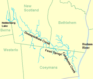
Onesquethaw Creek is a 14.5-mile-long (23.3 km) creek in Albany County, New York. It is a tributary of the Hudson River. It rises in the town of New Scotland, to the west of the hamlet of New Salem, in the Helderberg Mountains, and flows to Coeymans Creek in the town of Bethlehem, southwest of Delmar.

Clarksville, Albany County, New York Hamlet in New York, United States

Clarksville is a hamlet in the town of New Scotland, Albany County, New York. It is situated along Delaware Turnpike in the southern part of the town at the foot of the Helderberg Escarpment. It is the site of the Clarksville Cave and has an annual Clarksville Heritage Day and Car Show. It is in the Onesquethaw Volunteer Fire Company fire protection district.

Helderberg Escarpment

The Helderberg Escarpment also known as Helderberg Mountains is an escarpment and mountain range in eastern New York, roughly 11 miles (18 km) west of the city of Albany. The escarpment rises steeply from the Hudson Valley below, with an elevation difference of approximately 700 feet over a horizontal distance of approximately 2,000 feet. Much of the escarpment is within John Boyd Thacher State Park, and has views of the Hudson Valley and the Albany area.

History

O-nis'-ke-thau Creek is also called Coeymans Creek. There was a hamlet of this name in New Scotland as well as Oniskethau flats and mountain. It is said to have been an early Native American name meaning cornfields. [4]

New Scotland, New York Town in New York, United States

New Scotland is a town in Albany County, New York, United States. The population was 8,648 at the 2010 census.

Tributaries

See also

Onesquethaw Valley Historic District

Onesquethaw Valley Historic District is a national historic district principally located at New Scotland in Albany County, New York. It includes 25 contributing buildings and three contributing archaeological sites. In encompasses farmsteads and sites in part of the valley of Onesquethaw Creek, a tributary of Coeymans Creek. Most notable are eight 18th-century stone houses. The archaeological sites are a grist mill site, sawmill site, and a prehistoric Indian site.

Related Research Articles

East Canada Creek river in the United States of America

East Canada Creek is a 34.6-mile-long (55.7 km) river in upstate New York, United States. It is a tributary of the Mohawk River and flows southward from New York's Adirondack Park. The name "Canada" may be derived from the St. Lawrence Iroquoian word Kanata, meaning "village"; the name may also refer to the creek's importance as a trail to Canada in colonial times.

Carp River is a 40.2-mile-long (64.7 km) river in Chippewa and Mackinac counties in the U.S. state of Michigan. 21.7 miles (34.9 km) of the river were added to the National Wild and Scenic Rivers System in 1992.

The Estrella River is a 28.5-mile-long (45.9 km) tributary river in eastern San Luis Obispo County, California. The river forms at the confluence of Cholame Creek, from the north, and San Juan Creek, from the south, near the town of Shandon. From there it flows west-northwest to its confluence with the Salinas River, of which it is a tributary, 8 miles north of Paso Robles. Cholame Creek has its headwaters on the southwest side of Middle Mountain and its tributary, Little Cholame Creek, begins on the northeast side. The creek drains the Cholame Valley, which is bordered by Diablo Range on the east and Cholame Hills, a northern extension of the Temblor Range, on the west. The average precipitation in the area ranges from 11 to 17 inches, increasing northward.

San Jacinto River (California)

The San Jacinto River is a 42-mile-long (68 km) river in Riverside County, California. The river's headwaters are in San Bernardino National Forest, but the lower portion of the 765-square-mile (1,980 km2) watershed is urban and agricultural land. As a partially endorheic watershed that is contiguous with other Great Basin watersheds, the western side of the San Jacinto Basin is a portion of the Great Basin Divide.

Seneca Creek (North Fork South Branch Potomac River) river in the United States of America

Seneca Creek is a 19.6-mile-long (31.5 km) tributary of the North Fork of the South Branch of the Potomac River located entirely within Pendleton County, West Virginia, USA.

Wappinger Creek river in the United States of America

Wappinger Creek is a 41.7-mile-long (67.1 km) creek which runs from Thompson Pond to the Hudson River at New Hamburg in Dutchess County, New York, United States. It is the longest creek in Dutchess County, with the largest watershed in the county.

Maintop Mountain mountain in United States of America

Maintop Mountain is a mountain in Nelson County, Virginia. The mountain is a peak on a spur off the main Blue Ridge Mountains, about 2 miles (3 km) east of Elk Pond Mountain, and about 3.5 miles (5.5 km) west of The Priest. The mountain is located in the George Washington National Forest.

Maacama Creek stream in California

Maacama Creek is a 7.3-mile-long (11.7 km) stream in northern Sonoma County, California, U.S.A., which empties into the Russian River near the city of Healdsburg.

Alcove Reservoir

Alcove Reservoir is a reservoir located in Albany County, New York, United States. It serves as water supply for the city of Albany. At 618 ft (188 m) in elevation, the closest hamlet is Alcove, part of the town of Coeymans. New York State Route 32 passes the reservoir on the west. It was built 1928–1932, inundating the village of Indian Fields.

The Moordener Kill is a 15.5-mile-long (24.9 km) tributary to the Hudson River that flows through southwestern Rensselaer County, New York, in the United States.

Catskill Creek river in the United States of America

Catskill Creek is a 46.0-mile-long (74.0 km) tributary of the Hudson River that drains the northeastern Catskill Mountains of the U.S. State of New York. From its source at Franklinton Vlaie in Schoharie County it flows southeast through parts of Albany County and Greene County to its mouth at the village of Catskill on the Hudson River.

Lake Creek is a 5.8-mile-long (9.3 km) tributary of Catskill Creek in Albany and Schoharie counties, New York, in the United States. Via Catskill Creek, it is part of the Hudson River watershed. Lake Creek runs from the Rensselaerville State Forest in the town of Rensselaerville to Catskill Creek at Livingstonville in the town of Broome.

Bowery Creek is a 6.0-mile-long (9.7 km) tributary of Catskill Creek north of the Catskill Mountains of New York. Via Catskill Creek, it is part of the Hudson River watershed. Bowery Creek rises east of Windham High Peak in the northern part of the town of Cairo and flows northeast to Catskill Creek west of Freehold.

The Sawyer Kill or Sawyer's Kill is a 7.0-mile-long (11.3 km) tributary stream of the Hudson River in New York state. The source is at the Great Vlaie on the border of Ulster and Greene counties. The stream enters the Hudson River at Seamon Park in Malden, New York, just north of the village of Saugerties.

Jemez River river in the United States of America

The Jemez River is a tributary of the Rio Grande in the U.S. state of New Mexico. The river is formed by the confluence of the East Fork Jemez River and San Antonio Creek, which drain a number of tributaries in the area of the Jemez Mountains and Santa Fe National Forest. The Jemez River is about 50 miles (80 km) long, or about 80 miles (130 km) long if its longest headwater tributary, San Antonio Creek, is included. The East Fork Jemez River is about 22 miles (35 km) long. Both San Antonio Creek and the East Fork Jemez River flow through intricate meanders along their courses. The East Fork Jemez is a National Wild and Scenic River.

Kaaterskill Creek is a 25.9-mile-long (41.7 km) tributary of Catskill Creek in Greene and Ulster counties in New York. Via Catskill Creek, it is part of the Hudson River watershed.

Hannacrois Creek river in the United States of America

Hannacrois Creek is a 20.9-mile-long (33.6 km) tributary to the Hudson River in the U.S. state of New York. From its source in Westerlo it flows through Dunbar Hollows and over Dickinson Falls to the Alcove Reservoir. It then passes through Coeymans Hollow and just into Greene County to its mouth at the Hudson River in Coeymans, New York.

Taghkanic Creek is a 30.1-mile-long (48.4 km) tributary to Claverack Creek in Columbia County, New York, in the United States. Via Claverack Creek and Stockport Creek, it is part of the Hudson River watershed. Its source is in the town of Hillsdale, and it passes through the towns of Copake, Taghkanic, and Livingston before terminating at Claverack Creek in the town of Greenport.

References