Marcy, New York

Last updated

Marcy, New York
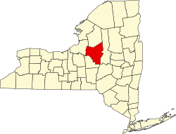
Oneida County New York incorporated and unincorporated areas Marcy highlighted.svg
Location in Oneida County and the state of New York.
Coordinates: 43°10′N75°17′W / 43.167°N 75.283°W / 43.167; -75.283
CountryUnited States
State New York
County Oneida
Government
  Type Town Council
   Town Supervisor Brian N. Scala (R)
   Town Council
Members' List
Area
[1]
  Total33.32 sq mi (86.29 km2)
  Land32.89 sq mi (85.18 km2)
  Water0.43 sq mi (1.11 km2)
Elevation
827 ft (252 m)
Population
 (2020) [2]
  Total8,777
  Density286.11/sq mi (110.47/km2)
Time zone UTC-5 (Eastern (EST))
  Summer (DST) UTC-4 (EDT)
ZIP code
13403
Area code 315
FIPS code 36-45535
GNIS feature ID0979197
Website Town of Marcy, NY

Marcy is a town in Oneida County, New York, United States. The population was 8,777 at the 2020 census. The town was named after Governor William L. Marcy. [3] It lies between the cities of Rome and Utica. The Erie Canal passes through the southern part of the town.

Contents

The town is home to the SUNY Polytechnic Institute, a four-year public research university in the southeastern part of town.

History

The first settlers arrived circa 1773. During the American Revolution, the settlers, having been warned by a friendly Oneida Indian about an enemy raid, abandoned their farms until after the war. The town was resettled in 1792.

The Town of Marcy was formed in 1832 from part of the Town of Deerfield, located to the east.

In 1920, the population of Marcy was 1,919.

The Neck Canal of 1730 was listed on the National Register of Historic Places in 1995. [4]

Geography

According to the United States Census Bureau, the town has a total area of 33.4 square miles (87 km2), of which 33.0 square miles (85 km2) is land and 0.4 square miles (1.0 km2) (1.35%) is water.

The Mohawk River defines the southern town line.

The New York State Thruway (Interstate 90) passes through the southeastern corner of the town.

The Erie Canal (also known as the Barge Canal) passes through the south end of the town, running along River Road, with Lock 20 Canal Park just east of the Route 291 bridge lying on the canal.

SUNY Polytechnic Institute is located on 700 acres northwest of the intersection of the North-South Arterial (NY 8 and NY 12) and NY 49.

Demographics

Historical population
CensusPop.Note
1840 1,799
1850 1,8573.2%
1860 1,687−9.2%
1870 1,451−14.0%
1880 1,413−2.6%
1890 1,213−14.2%
1900 1,39815.3%
1910 1,301−6.9%
1920 1,191−8.5%
1930 2,604118.6%
1940 4,52873.9%
1950 5,21015.1%
1960 7,02434.8%
1970 7,87712.1%
1980 6,222−21.0%
1990 8,68539.6%
2000 9,4819.2%
2010 8,982−5.3%
2020 8,777−2.3%
U.S. Decennial Census [5] [2]

As of the census [6] of 2000, there were 9,469 people, 2,003 households, and 1,526 families residing in the town. The population density was 287.2 inhabitants per square mile (110.9/km2). There were 2,073 housing units at an average density of 62.9 per square mile (24.3/km2). The racial makeup of the town was 68.42% White, 22.20% African American, 0.27% Native American, 0.60% Asian, 0.04% Pacific Islander, 6.55% from other races, and 1.91% from two or more races. Hispanic or Latino of any race were 14.02% of the population.

There were 2,003 households, out of which 33.0% had children under the age of 18 living with them, 65.5% were married couples living together, 6.9% had a female householder with no husband present, and 23.8% were non-families. 19.6% of all households were made up of individuals, and 8.0% had someone living alone who was 65 years of age or older. The average household size was 2.60 and the average family size was 2.99.

In the town, the population was spread out, with 13.2% under the age of 18, 13.4% from 18 to 24, 44.7% from 25 to 44, 20.3% from 45 to 64, and 8.5% who were 65 years of age or older. The median age was 36 years. For every 100 females, there were 242.8 males. For every 100 females age 18 and over, there were 276.2 males.

The median income for a household in the town was $47,180, and the median income for a family was $54,231. Males had a median income of $30,943 versus $25,044 for females. The per capita income for the town was $16,182. About 3.7% of families and 5.4% of the population were below the poverty line, including 9.2% of those under age 18 and 2.3% of those age 65 or over.

Communities and locations in Marcy

Notable people

— Carroll C. Potter, justice of the peace of Marcy for many years and a captain of the Reserve Corps during the Civil War, died Saturday night at 10 o'clock at the home of his nieces, Mrs. H. A. Humphrey in Marcy, following an in illness of three weeks. Mr. Potter had been in poor health for three years and as on Saturday he seemed to be feeling a little better than usual, the end came rather unexpectedly. Mr. Potter was one of the best-known citizens of the county, a prosperous farmer, a charter member of the Marcy Grange, No. 720, one of the oldest members of the Central New York of the Farmers' Club and for some time president of the Marcy Center Cheese Factory Association. During the summer Mr. Potter lived on the farm and in the winters had made his home in Utica. He was born in Marcy in the home where he died, September 19, 1832, six years after the family had moved to Oneida County from Bennington, VT. On graduating from Whitestown Seminary he began the study of law in the offices of William Merril of Whitestown, but when his health failed, he went West and studied railroad engineering at Fon du Lac, Wis. He was also in the employ of the Utica & Black River Railroad and the Toledo, Wabash & St. Louis Railroad.

Related Research Articles

<span class="mw-page-title-main">Oneida County, New York</span> County in New York, United States

Oneida County is a county in the state of New York, United States. As of the 2020 census, the population was 232,125. The county seat is Utica. The name is in honor of the Oneida, one of the Five Nations of the Iroquois League or Haudenosaunee, which had long occupied this territory at the time of European encounter and colonization. The federally recognized Oneida Indian Nation has had a reservation in the region since the late 18th century, after the American Revolutionary War.

<span class="mw-page-title-main">Schuyler, New York</span> Town in Herkimer County, New York, US

Schuyler is a town in Herkimer County, New York, United States. The population was 3,420 at the 2010 census. The town is in the western part of Herkimer County and is east of Utica.

<span class="mw-page-title-main">Oneida, New York</span> City in Madison County, New York, US

Oneida is a city in Madison County in the U.S. state of New York. It is located west of Oneida Castle and east of Wampsville. The population was 11,390 at the 2010 census. The city, like both Oneida County and the nearby silver and china maker, was named for the Oneida tribe, which had a large territory here around Oneida Lake during the colonial period.

<span class="mw-page-title-main">Augusta, New York</span> Town in New York, United States

Augusta is a town in Oneida County, New York, United States. The population was 2,020 at the 2010 census.

<span class="mw-page-title-main">Deerfield, New York</span> Town in New York, United States

Deerfield is a town in Oneida County, New York, United States. The population was 4,273 at the 2010 census.

<span class="mw-page-title-main">Floyd, New York</span> Town in New York, United States

Floyd is a town in Oneida County, New York, United States. The population was 3,819 at the 2010 census. The town is named after William Floyd, a signer of the Declaration of Independence.

<span class="mw-page-title-main">Paris, New York</span> Town in New York, United States

Paris is a town in Oneida County, New York, United States. The town is in the southeast part of the county and is south of Utica. The population was 4,411 at the 2010 census. The town was named after an early benefactor, Colonel Isaac Paris.

<span class="mw-page-title-main">Steuben, New York</span> Town in Oneida County, New York, US

Steuben is a town in Oneida County, New York, United States. The population was 1,110 at the 2010 census. The town is named after Baron von Steuben, a Prussian general who fought on the American side in the American Revolutionary War.

<span class="mw-page-title-main">Verona, New York</span> Town in New York, United States

Verona is a town in southwestern Oneida County, New York, United States. The population was 6,293 at the 2010 census. The town was named after Verona, Italy.

<span class="mw-page-title-main">Vienna, New York</span> Town in New York, United States

Vienna is a town in Oneida County, New York, United States. The population was 5,440 at the 2010 census. The town is named after the capital of Austria.

<span class="mw-page-title-main">Westmoreland, New York</span> Town in New York, United States

Westmoreland is a town in Oneida County, New York, United States. The population was 6,138 at the 2010 census.

<span class="mw-page-title-main">Whitesboro, New York</span> Village in New York, United States

Whitesboro is a village in Oneida County, New York, United States. The population was 3,772 at the 2010 census. The village is named after Hugh White, an early settler.

<span class="mw-page-title-main">Whitestown, New York</span> Town in New York, United States

Whitestown is a town in Oneida County, New York, United States. The population was 18,667 at the 2010 census. The name is derived from Judge Hugh White, an early settler. The town is immediately west of Utica and the New York State Thruway passes across the town. The offices of the town of Whitestown are in the Village of Whitesboro.

<span class="mw-page-title-main">Yorkville, Oneida County, New York</span> Village in New York, United States

Yorkville is a village in Oneida County, New York, United States. The population was 2,689 at the 2010 census.

<span class="mw-page-title-main">Lysander, New York</span> Town in New York, United States

Lysander is a town in Onondaga County, New York, United States. As of the 2020 Census, the population was 23,074. The town was named after Lysander, a Spartan military leader, by a clerk interested in the classics. Lying to the northwest of Syracuse, much of the town is suburban in character.

<span class="mw-page-title-main">Little Falls (town), New York</span> Town in New York, United States

Little Falls is a town in Herkimer County, New York, United States. The population was 1,587 at the 2010 census. The town is named after falls and rapids on the Mohawk River nearby.

<span class="mw-page-title-main">Boonville, New York</span> Town in New York, United States

Boonville is a town in Oneida County, New York, United States. The town is in the northeastern section of the county. The population was 4,555 at the 2010 census. The town includes a village, also called Boonville. The town and village are named after Gerrit Boon, an agent of the Holland Land Company. The current mayor is Judith Dellerba.

<span class="mw-page-title-main">New Hartford, New York</span> Town in New York, United States

New Hartford is a town in Oneida County, New York, United States. As of the 2010 census, the town population was 22,166. The name of New Hartford was provided by a settler family from Hartford, Connecticut.

<span class="mw-page-title-main">Constantia (town), New York</span> Town in New York, United States

Constantia is a town in Oswego County, New York, United States. The population was 4,973 at the 2010 census.

<span class="mw-page-title-main">Utica–Rome metropolitan area</span> Metropolitan area in New York, United States

The Utica–Rome Metropolitan Statistical Area, as defined by the United States Census Bureau, is an area consisting of two counties in Central New York anchored by the cities of Utica and Rome. As of the 2020 census, the MSA had a population of 292,264.

References

  1. "2016 U.S. Gazetteer Files". United States Census Bureau. Retrieved July 5, 2017.
  2. 1 2 "2020 Census Data". United States Census Bureau. Retrieved August 5, 2023.
  3. Gannett, Henry (1905). The Origin of Certain Place Names in the United States. U.S. Government Printing Office. p. 199.
  4. "National Register Information System". National Register of Historic Places . National Park Service. March 13, 2009.
  5. "Census of Population and Housing". Census.gov. Retrieved June 4, 2015.
  6. "U.S. Census website". United States Census Bureau . Retrieved January 31, 2008.
  7. Fusco, Jennifer; Rocco LaDuca (September 14, 2009). "Would-be Ford assassin 'Squeaky' Fromme moving to Marcy". Observer Dispatch. Archived from the original on September 19, 2012. Retrieved September 28, 2009.
  8. 'Wisconsin Blue Book 1875,' Biographical Sketch of Rouse Simmons, pg. 326
  9. Memorial Art Gallery

43°10′N75°17′W / 43.167°N 75.283°W / 43.167; -75.283