
The following is a list of landforms and other geographical features located within the political boundaries of Sussex County in northwestern New Jersey in the United States.
The following is a list of landforms and other geographical features located within the political boundaries of Sussex County in northwestern New Jersey in the United States.


Sussex County is the northernmost county in the U.S. state of New Jersey. Its county seat is Newton. It is part of the New York metropolitan area and is part of New Jersey's Skylands Region. As of the 2020 census, the county was the state's 17th-most-populous county, with a population of 144,221, a decrease of 5,044 (−3.4%) from the 2010 census count of 149,265, which in turn reflected an increase of 5,099 (+3.5%) over the 144,166 persons at the 2000 census. Based on 2020 census data, Vernon Township was the county's largest in both population and area, with a population of 22,358 and covering an area of 70.59 square miles (182.8 km2). The county is part of the North Jersey region of the state.

The Wallkill River, a tributary of the Hudson, drains Lake Mohawk in Sparta, New Jersey, flowing from there generally northeasterly 88.3 miles (142.1 km) to Rondout Creek in New York, just downstream of Sturgeon Pool, near Rosendale, with the combined flows reaching the Hudson at Kingston.

Kittatinny Mountain is a long ridge traversing primarily across Sussex County in northwestern New Jersey, running in a northeast-southwest axis, a continuation across the Delaware Water Gap of Pennsylvania's Blue Mountain. It is the first major ridge in the far northeastern extension of the Ridge and Valley province of the Appalachian Mountains, and reaches its highest elevation, 1,803 feet, at High Point in Montague Township. Kittatinny Mountain forms the eastern side of Wallpack Valley; the western side comprises the Wallpack Ridge (highest elevation: 928 feet above sea level.

The Paulins Kill is a 41.6-mile (66.9 km) tributary of the Delaware River in northwestern New Jersey in the United States. With a long-term median flow rate of 76 cubic feet of water per second (2.15 m³/s), it is New Jersey's third-largest contributor to the Delaware River, behind the Musconetcong River and Maurice River. The river drains an area of 176.85 square miles (458.0 km2) across portions of Sussex and Warren counties and 11 municipalities. It flows north from its source near Newton, and then turns southwest. The river sits in the Ridge and Valley geophysical province.

Wawayanda Creek is the name of Pochuck Creek above its confluence with the tributary Black Creek. It is 17.0 miles (27.4 km) long. Wawayanda Creek, via Pochuck Creek, is a tributary of the Wallkill River in Sussex County, New Jersey in the United States. It starts northeast of Warwick, New York, and runs southwest, mostly within Orange County, flowing into New Jersey for several miles to its confluence with Black Creek just north of Highland Lakes, forming Pochuck Creek, which flows north back into New York.
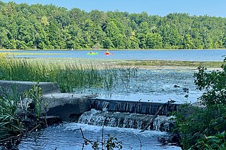
Pochuck Creek is an 8.1-mile-long (13.0 km) tributary of the Wallkill River in Orange County, New York and Sussex County, New Jersey, in the United States.

Papakating Creek is a 20.1-mile-long (32.3 km) tributary of the Wallkill River located in Frankford and Wantage townships in Sussex County, New Jersey in the United States. The creek rises in a small swamp located beneath the eastern face of Kittatinny Mountain in Frankford and its waters join the Wallkill to the east of Sussex borough.

Schooley's or, officially, Schooleys Mountain is a mountain ridge in northern New Jersey that stretches from Lake Hopatcong in the north to Hampton in the south. It is centrally located within the southern Highlands, positioned almost equidistantly from the Kittatinny Valley in the west and the Piedmont plateau in the east. Schooley's Mountain is also one of the largest ridges in a group of geologically similar and parallel mountains, which include Allamuchy Mountain, Pohatcong Mountain, Scotts Mountain, and Jenny Jump Mountain.
Kittatinny Valley State Park is located in Andover Township and extends into Andover Borough, New Jersey. Features include Glacial lakes, limestone outcroppings, former railroads, and a small airport. Lake Aeroflex and Gardner's Pond form part of the headwaters of the Pequest River and are excellent for fishing and boating. The park is home to a variety of wildlife such as whitetail deer, wild turkeys, a variety of songbirds, beavers, muskrats, and squirrels. The park is operated and maintained by the New Jersey Division of Parks and Forestry.

The Skylands Region is a region of New Jersey located in the northern and central parts of the state. It is one of six tourism regions established by the New Jersey State Department of Tourism; the others are Gateway Region, Greater Atlantic City Region, the Southern Shore Region, the Delaware River Region, and the Shore Region.

Stokes State Forest is a state park located in Sandyston, Montague and Frankford in Sussex County, New Jersey, United States. Stokes comprises 16,447 acres (66.56 km2) of mountainous woods in the Kittatinny Mountains, extending from the southern boundary of High Point State Park southwestward to the eastern boundary of the Delaware Water Gap National Recreation Area. The park is operated and maintained by the New Jersey Division of Parks and Forestry.
New Jersey is a very geologically and geographically diverse region in the United States' Middle Atlantic region, offering variety from the Appalachian Mountains and the Highlands in the state's northwest, to the Atlantic Coastal Plain region that encompasses both the Pine Barrens and the Jersey Shore. The state's geological features have impacted the course of settlement, development, commerce and industry over the past four centuries.

The Black Dirt Region is located in southern Orange County, New York and northern Sussex County, New Jersey. It is mostly located in the western section of the Town of Warwick, centered on the hamlet of Pine Island. Some sections spill over into adjacent portions of the towns of Chester, Goshen and Wawayanda in New York and parts of Wantage and Vernon, New Jersey. Before the region was drained, around 1880 by the Polish and Volga German immigrants through drainage culverts and the construction of the Delaware and Hudson Canal, it was a densely-vegetated marsh known as the "Drowned Lands of the Wallkill".

Pochuck Mountain is a ridge in the New York-New Jersey Highlands region of the Appalachian Mountains. Pochuck Mountain's summit and most of its peaks lie within Vernon Township, Sussex County, New Jersey, although the south-western portion of the ridge lies within Hardyston Township, and the north-eastern tip of the ridge extends over the New York state line into Orange County. The ridge marks the eastern edge of the Great Appalachian Valley, and it divides the watersheds of the Wallkill River and its tributary Pochuck Creek. The two rivers meet at Pochuck Neck, marking the terminus of the ridge.

Wawayanda Mountain is a ridge in the New York-New Jersey Highlands region of the Appalachian Mountains. The summit lies within Sussex County, New Jersey.

The Kittatinny Valley is a section of the Great Appalachian Valley in Sussex and Warren counties in northwestern New Jersey that is bounded on the northwest by Kittatinny Mountain, and in the southeast by the New Jersey Highlands region. The valley is roughly 40 miles (64 km) long, with a breadth of 10 to 13 miles.

The Minisink or Minisink Valley is a loosely defined geographic region of the Upper Delaware River valley in northwestern New Jersey, northeastern Pennsylvania and New York.
The Hamburg Mountains are a range of the New York-New Jersey Highlands region of the Appalachian Mountains. The summit, reaching a height of 1,473 feet (449 m), lies within Sussex County, New Jersey.