Wallpack Ridge

Last updated
Wallpack Ridge
Walpack Ridge

Wallpack Ridge from Mountain Road in Walpack Township New Jersey.jpg

Wallpack Ridge seen from Mountain Road
Highest point
Elevation 928 ft (283 m)
Coordinates 41°8′7.649″N74°54′34.65″W / 41.13545806°N 74.9096250°W / 41.13545806; -74.9096250
Geography
Location map of Sussex County, New Jersey.svg
Red triangle with thick white border.svg
Sussex County, New Jersey
Range coordinates 41°14′1.234″N74°51′10.147″W / 41.23367611°N 74.85281861°W / 41.23367611; -74.85281861 Coordinates: 41°14′1.234″N74°51′10.147″W / 41.23367611°N 74.85281861°W / 41.23367611; -74.85281861
Parent range Kittatinny Mountain
Geology
Age of rock Late Silurian
Mountain type Dendritic ridge
Climbing
Access Restricted access roads


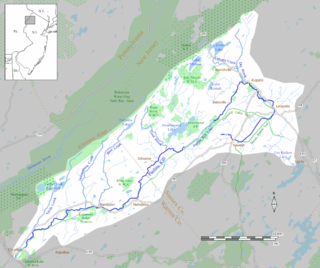
Wallpack Ridge (or Walpack Ridge) is a mountain located in the Ridge and Valley Appalachians physiographic province in Sussex County in northwestern New Jersey. Oriented northeast to southwest, Wallpack Ridge spans 25 miles (40 km) from Montague Township south of Port Jervis, New York to the Walpack Bend in the Delaware River near Flatbrookville in Walpack Township. It is a narrow ridge ranging between 0.67 miles (1.08 km) to 1.7 miles (2.7 km) in width, and its highest elevation reaches 928 feet (283 m) above sea level. [1] The ridge separates the Wallpack Valley from the valley of the Delaware River (also known as the Minisink or Minisink Valley), and contains the watershed of the Flat Brook and its main tributaries Big Flat Brook and Little Flat Brook. [2]

A physiographic province is a geographic region with a characteristic geomorphology, and often specific subsurface rock type or structural elements.

Sussex County, New Jersey County in the United States

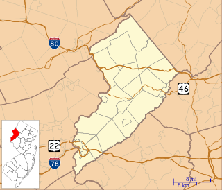
Sussex County is the northernmost county in the State of New Jersey. Its county seat is Newton. It is part of the New York Metropolitan Area and is part of the state's Skylands Region, a term promoted by the New Jersey Commerce, Economic Growth, & Tourism Commission to encourage tourism. As of the 2017 Census estimate, the county's population was 141,682, making it the 17th-most populous of the state's 21 counties, a 5.1% decrease from the 149,265 enumerated in the 2010 United States Census, in turn an increase of 5,099 (3.5%) over the 144,166 persons enumerated in the 2000 Census. Based on 2010 Census data, Vernon Township was the county's largest in both population and area, with a population of 23,943 and covering an area of 70.59 square miles (182.8 km2).

New Jersey State of the United States of America

New Jersey is a state in the Mid-Atlantic and Northeastern regions of the United States. It is located on a peninsula, bordered on the north and east by the state of New York, particularly along the extent of the length of New York City on its western edge; on the east, southeast, and south by the Atlantic Ocean; on the west by the Delaware River and Pennsylvania; and on the southwest by the Delaware Bay and Delaware. New Jersey is the fourth-smallest state by area but the 11th-most populous, with 9 million residents as of 2017, and the most densely populated of the 50 U.S. states; its biggest city is Newark. New Jersey lies completely within the combined statistical areas of New York City and Philadelphia. New Jersey was the second-wealthiest U.S. state by median household income as of 2017.

A controversial project to build a hydroelectric dam and reservoir on the Delaware River in the 1950s and 1960s led to government's seizure of land in northwestern New Jersey and northeastern Pennsylvania under the authority of the U.S. Army Corps of Engineers. The construction of the dam would have created a lake reservoir that would have flooded the Walpack Valley. For political and geological reasons, the dam project was deauthorized and the land transferred to the management of the National Park Service for the establishment of a National Recreation Area. [3] Currently, Wallpack Ridge is located in the Delaware Water Gap National Recreation Area that was established by the National Park Service in 1978.

National Park Service United States federal agency

The National Park Service (NPS) is an agency of the United States federal government that manages all national parks, many national monuments, and other conservation and historical properties with various title designations. It was created on August 25, 1916, by Congress through the National Park Service Organic Act and is an agency of the United States Department of the Interior. The NPS is charged with a dual role of preserving the ecological and historical integrity of the places entrusted to its management, while also making them available and accessible for public use and enjoyment.

National Recreation Area type of protected area in the United States

A National Recreation Area (NRA) is a designation for a protected area in the United States.

Delaware Water Gap National Recreation Area protected area

The Delaware Water Gap National Recreation Area is a 70,000 acres (28,000 ha) protected area designated a National Recreation Area administered by the U.S. Department of the Interior's National Park Service. It is located along the middle section of the Delaware River in New Jersey and Pennsylvania stretching from the Delaware Water Gap northward in New Jersey to the state line near Port Jervis, New York, and in Pennsylvania to the outskirts of Milford. A 40-mile (64 km) section of the Delaware River, entirely within the National Recreation Area, has been granted protected status as the Middle Delaware National Scenic River under the National Wild and Scenic Rivers System and is also administered by the National Park Service. This section of the river is the core of the historical Minisink region.

See also

The Brau Kettle is a geological feature known as a karst that is located along the Wallpack Ridge in the Delaware Water Gap National Recreation Area in Sandyston Township, New Jersey. Its name derives from the Dutch for "brewing kettle" or "boiling kettle" which describes how water suddenly bubbles up from the ground. This site is referenced in early French Jesuit and Dutch colonial manuscripts as a landmark near which colonial traders exchanged goods with the Munsee and other local Native American tribes. According to the New Jersey Geological Survey, the feature looks like a sinkhole in dry times during the year. It is known to flow at random, after periods of precipitation, and is thought to be fed by a sinking stream that vanishes in the forest roughly 1,800 feet away.

New Jersey is a very geologically and geographically diverse region in the United States' Middle Atlantic region, offering variety from the Appalachian Mountains and the Highlands in the state's northwest, to the Atlantic Coastal Plain region that encompasses both the Pine Barrens and the Jersey Shore. The state's geological features have impacted the course of settlement, development, commerce and industry over the past four centuries.

Old Mine Road is a road in New Jersey and New York said to be one of the oldest continuously used roads in the United States of America. At a length of 104 miles (167 km), it stretches from the Delaware Water Gap National Recreation Area to the vicinity of Kingston, New York.

Related Research Articles

Delaware River major river on the East coast of the United States of America

The Delaware River is a major river on the Atlantic coast of the United States. It drains an area of 14,119 square miles (36,570 km2) in five U.S. states: Delaware, Maryland, New Jersey, New York, Pennsylvania. Rising in two branches in New York state's Catskill Mountains, the river flows 419 miles (674 km) into Delaware Bay where its waters enter the Atlantic Ocean near Cape May in New Jersey and Cape Henlopen in Delaware. Not including Delaware Bay, the river's length including its two branches is 388 miles (624 km). The Delaware River is one of nineteen "Great Waters" recognized by the America's Great Waters Coalition.

A 1950s proposal to construct a dam near Tocks Island across the Delaware River was met with considerable controversy and protest. Tocks Island is located in the Delaware River a short distance north from the Delaware Water Gap. In order to control damaging flooding and provide clean water to supply New York City and Philadelphia, the U.S. Army Corps of Engineers proposed building a dam. When completed, the Tocks Island Dam would have created a 37-mile (60-km) long lake between Pennsylvania and New Jersey, with depths of up to 140 feet. This lake and the land surrounding were to be organized as the Tocks Island National Recreation Area. Although the dam was never built, 72,000 acres (291 km²) of land were acquired by condemnation and eminent domain. This incited environmental protesters and embittered local residents displaced by the project's preparations when their property was condemned. After the Tocks Island Dam project was withdrawn, the lands acquired were transferred to the oversight of the National Park Service which reorganized them to establish the Delaware Water Gap National Recreation Area.

Kittatinny Mountain mountain in United States of America

Kittatinny Mountain is a long ridge traversing across northwestern New Jersey running in a northeast-southwest axis, a continuation across the Delaware Water Gap of Pennsylvania's Blue Mountain Ridge. It is the first major ridge in the far northeastern extension of the Ridge and Valley province of the Appalachian Mountains, and reaches its highest elevation, 1,803 feet, at High Point in Montague Township. Kittatinny Mountain forms the eastern side of Wallpack Valley; the western side comprises the Wallpack Ridge (highest elevation: 928 feet above sea level.

Blue Mountain (Pennsylvania) ridge that forms the eastern edge of the Appalachian mountain range in the U.S. state of Pennsylvania

Blue Mountain Ridge, Blue Mountain, or the Blue Mountains of Pennsylvania is part of the geophysical makeup of the Ridge-and-Valley Appalachians in the U.S. state of Pennsylvania. It is a ridge that forms the southern and eastern edge of the Appalachian mountain range spanning over 255 miles (410 km) from the Delaware Water Gap as it cuts across the eastern half of the state on a slight diagonal from New Jersey tending southerly until it turns southerly curving into Maryland, and beyond.

Flat Brook

Flat Brook is an 11.6-mile-long (18.7 km) tributary of the Delaware River in Sussex County, New Jersey in the United States.

Paulins Kill river in the United States of America

The Paulinskill is a 41.6-mile (66.9 km) tributary of the Delaware River in northwestern New Jersey in the United States. With a long-term median flow rate of 76 cubic feet of water per second (2.15 m³/s), it is New Jersey's third-largest contributor to the Delaware River, behind the Musconetcong River and Maurice River. The Paulinskill drains an area of 176.85 square miles (458.0 km2) across portions of Sussex and Warren counties and 11 municipalities. The Paulinskill flows north from its source near Newton, and then turns southwest. The river sits in the Ridge and Valley geophysical province.

Pahaquarry Township, New Jersey Place in New Jersey, United States

Pahaquarry Township is a now-defunct township that was located in Warren County, New Jersey, United States, from 1824 until it was dissolved in 1997.

Swartswood State Park

Swartswood State Park is a 3,460-acre (14.0 km2) protected area located in the Swartswood section of Stillwater and Hampton townships in Sussex County, New Jersey, in the United States. Established in 1915 by the state's Forest Park Reservation Commission, it was the first state park established by the state of New Jersey for the purposes of recreation at the state's third-largest freshwater lake. Today, Swartswood State Park is operated and maintained by the New Jersey Division of Parks and Forestry.

The Military Road was a roadway built in the present-day U.S. state of New Jersey during the French and Indian War connecting Elizabethtown with a string of fortifications along the Delaware River in modern Sussex and Warren Counties in northwestern New Jersey. The road was conceived and built under the order of Jonathan Hampton, Esq., an Elizabethtown merchant and surveyor who was appointed as Victualer and Paymaster to the New Jersey Frontier Guard by an act of the New Jersey's colonial legislature.

Geology of Pennsylvania

The Geology of Pennsylvania consists of six distinct physiographic provinces, three of which are subdivided into different sections. Each province has its own economic advantages and geologic hazards and plays an important role in shaping everyday life in the state. They are: the Atlantic Coastal Plain Province, the Piedmont Province, the New England Province, the Ridge and Valley Province, the Appalachian Plateau Province, and the Central Lowlands Province.

National Park Route 615 is a route through the Delaware Water Gap National Recreation Area. The route consists of two parts, County Route 615, maintained by Sussex County, New Jersey, and the remainder of the route, maintained by the National Park Service.

Pahaquarry Copper Mine

The Pahaquarry Copper Mine is an abandoned copper mine located on the west side of Kittatinny Mountain presently in Hardwick Township in Warren County, New Jersey in the United States. Active mining was attempted for brief periods during the mid-eighteenth, mid-nineteenth, and early twentieth centuries but was never successful despite developments in mining technology and improving mineral extraction methods. Such ventures were not profitable as the ore extracted proved to be of too low a concentration of copper. This site incorporates the mining ruins, hiking trails, and nearby waterfalls, and is located within the Delaware Water Gap National Recreation Area and administered by the National Park Service.

Minisink

The Minisink or Minisink Valley is a loosely defined geographic region of the Upper Delaware River valley in northwestern New Jersey, northeastern Pennsylvania and New York.

Van Campen's Inn or Isaac Van Campen's Inn is a fieldstone residence that was used as a yaugh house during the American colonial era. Located in Walpack Township, New Jersey along the Delaware River, it is a historic site located along the Old Mine Road in the Delaware Water Gap National Recreation Area. It is operated under a memorandum of understanding between the National Park Service and the Walpack Historical Society, a local non-profit corporation.

Wallpack Valley valley in New Jersey, United States of America

Wallpack Valley is a valley located in Sussex County in northwestern New Jersey formed by Wallpack Ridge on the west, and Kittatinny Mountain on the east. Wallpack Ridge separates the Wallpack Valley from the valley of the Delaware River, and contains the watershed of the Flat Brook and its main tributaries Big Flat Brook and Little Flat Brook. It is a narrow valley, roughly 25 miles (40 km) in length running from Montague Township south of Port Jervis, New York to the Walpack Bend in the Delaware River near Flatbrookville in Walpack Township where the Flat Brook enters the Delaware at 300 feet above sea level.

References

  1. Witte, Ron W., and Monteverde Don H. "Karst in the Delaware Water Gap National Recreation Area" from Unearthing New Jersey (Newsletter) Vol. 2 No. 1 Winter 2006. (Trenton: New Jersey Geological Survey, Department of Environmental Protection, 2006).
  2. Witte, Ron W., and Monteverde Don H. "Geological History of New Jersey's Ridge and Valley Physiographic Province" (Trenton, New Jersey: New Jersey Geological and Water Survey. New Jersey Department of Environmental Protection, 2012).
  3. Feiveson, Harold; Sinden, Frank; and Socolow, Robert. Boundaries of Analysis: an Inquiry Into the Tocks Island Dam Controversy. (1976); Albert, Richard C. Damming the Delaware: The Rise and Fall of Tocks Island Dam (State College, Pennsylvania: Pennsylvania State University Press, 1987).