
The Delaware River is a major river on the Atlantic coast of the United States. It drains an area of 14,119 square miles (36,570 km2) in five U.S. states: Delaware, Maryland, New Jersey, New York, Pennsylvania. Rising in two branches in New York state's Catskill Mountains, the river flows 419 miles (674 km) into Delaware Bay where its waters enter the Atlantic Ocean near Cape May in New Jersey and Cape Henlopen in Delaware. Not including Delaware Bay, the river's length including its two branches is 388 miles (624 km). The Delaware River is one of nineteen "Great Waters" recognized by the America's Great Waters Coalition.
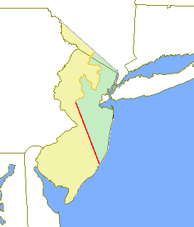
West Jersey and East Jersey were two distinct parts of the Province of New Jersey. The political division existed for 28 years, between 1674 and 1702. Determination of an exact location for a border between West Jersey and East Jersey was often a matter of dispute.

The Delaware and Raritan Canal is a canal in central New Jersey, United States, built in the 1830s, that served to connect the Delaware River to the Raritan River. It was an efficient and reliable means of transportation of freight between Philadelphia and New York City, especially coal from the anthracite fields in eastern Pennsylvania. The canal allowed shippers to cut many miles off the existing route from the Pennsylvania coal fields, down the Delaware, around Cape May, and up along the Atlantic Ocean coast to New York City.
A 1950s proposal to construct a dam near Tocks Island across the Delaware River was met with considerable controversy and protest. Tocks Island is located in the Delaware River a short distance north from the Delaware Water Gap. In order to control damaging flooding and provide clean water to supply New York City and Philadelphia, the U.S. Army Corps of Engineers proposed building a dam. When completed, the Tocks Island Dam would have created a 37-mile (60-km) long lake between Pennsylvania and New Jersey, with depths of up to 140 feet. This lake and the land surrounding were to be organized as the Tocks Island National Recreation Area. Although the dam was never built, 72,000 acres (291 km²) of land were acquired by condemnation and eminent domain. This incited environmental protesters and embittered local residents displaced by the project's preparations when their property was condemned. After the Tocks Island Dam project was withdrawn, the lands acquired were transferred to the oversight of the National Park Service which reorganized them to establish the Delaware Water Gap National Recreation Area.
Dingmans Ferry is an unincorporated community in Delaware Township, Pike County, Pennsylvania, United States. As of 2014, it had a population of 7,477 people. It was originally sited on the Delaware River, in an area now included in the Delaware Water Gap National Recreation Area. When the Corps of Engineers acquired the land by eminent domain in the mid-twentieth century for the creation of the proposed Tocks Island Dam project, it relocated the community further up the hill.

Blue Mountain Ridge, Blue Mountain, or the Blue Mountains of Pennsylvania is part of the geophysical makeup of the Ridge-and-Valley Appalachians in the U.S. state of Pennsylvania. It is a ridge that forms the southern and eastern edge of the Appalachian mountain range spanning over 255 miles (410 km) from the Delaware Water Gap as it cuts across the eastern half of the state on a slight diagonal from New Jersey tending southerly until it turns southerly curving into Maryland, and beyond.

Flat Brook is an 11.6-mile-long (18.7 km) tributary of the Delaware River in Sussex County, New Jersey in the United States.
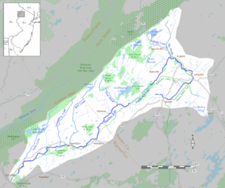
The Paulinskill is a 41.6-mile (66.9 km) tributary of the Delaware River in northwestern New Jersey in the United States. With a long-term median flow rate of 76 cubic feet of water per second (2.15 m³/s), it is New Jersey's third-largest contributor to the Delaware River, behind the Musconetcong River and Maurice River. The Paulinskill drains an area of 176.85 square miles (458.0 km2) across portions of Sussex and Warren counties and 11 municipalities. The Paulinskill flows north from its source near Newton, and then turns southwest. The river sits in the Ridge and Valley geophysical province.

The Millstone River is a 38.6-mile-long (62.1 km) tributary of the Raritan River in central New Jersey in the United States.
Old Mine Road is a road in New Jersey and New York said to be one of the oldest continuously used roads in the United States of America. At a length of 104 miles (167 km), it stretches from the Delaware Water Gap National Recreation Area to the vicinity of Kingston, New York.
The Keith line was a line drawn through the Province of New Jersey, dividing it into the Province of West Jersey and the Province of East Jersey. The line was created by Surveyor-General George Keith in 1686, when he ran the first survey to mark out the border between West Jersey and East Jersey. The Keith line was intended to clarify disputes resulting from the 1676 Quintipartite Deed, which created the two territories.

The Skylands Region is a region and marketing area of the State of New Jersey located in the Northern and Central part of the state. It is one of six tourism regions established by the New Jersey State Department of Tourism, the others being the Gateway Region, Greater Atlantic City Region, the Southern Shore Region, the Delaware River Region and the Shore Region. The area officially encompasses Hunterdon, Morris, Somerset, Sussex and Warren counties; the northwestern part of the Passaic County fits in with the Skylands Region, but it is part of the Gateway Region and not the Skylands Region. One could also say that the western most part of Bergen is also part of the skylands. The area features uplifted land, rolling hills and mountains characteristic of North Jersey. The region contains 60,000 acres of state parkland, and a diverse geography filled with lakes, rivers and picturesque hills.

The Pahaquarry Copper Mine is an abandoned copper mine located on the west side of Kittatinny Mountain presently in Hardwick Township in Warren County, New Jersey in the United States. Active mining was attempted for brief periods during the mid-eighteenth, mid-nineteenth, and early twentieth centuries but was never successful despite developments in mining technology and improving mineral extraction methods. Such ventures were not profitable as the ore extracted proved to be of too low a concentration of copper. This site incorporates the mining ruins, hiking trails, and nearby waterfalls, and is located within the Delaware Water Gap National Recreation Area and administered by the National Park Service.

The Minisink or Minisink Valley is a loosely defined geographic region of the Upper Delaware River valley in northwestern New Jersey, northeastern Pennsylvania and New York.
Van Campen's Inn or Isaac Van Campen's Inn is a fieldstone residence that was used as a yaugh house during the American colonial era. Located in Walpack Township, New Jersey along the Delaware River, it is a historic site located along the Old Mine Road in the Delaware Water Gap National Recreation Area. It is operated under a memorandum of understanding between the National Park Service and the Walpack Historical Society, a local non-profit corporation.

Wallpack Valley is a valley located in Sussex County in northwestern New Jersey formed by Wallpack Ridge on the west, and Kittatinny Mountain on the east. Wallpack Ridge separates the Wallpack Valley from the valley of the Delaware River, and contains the watershed of the Flat Brook and its main tributaries Big Flat Brook and Little Flat Brook. It is a narrow valley, roughly 25 miles (40 km) in length running from Montague Township south of Port Jervis, New York to the Walpack Bend in the Delaware River near Flatbrookville in Walpack Township where the Flat Brook enters the Delaware at 300 feet above sea level.


