Saratoga County, New York

Last updated

Saratoga County
Downtown Saratoga Springs.jpg
Flag of Saratoga County, New York.jpg
SaratogaCountySeal.png
Map of New York highlighting Saratoga County.svg
Location within the U.S. state of New York
New York in United States.svg
New York's location within the U.S.
Coordinates: 43°07′N73°52′W / 43.11°N 73.87°W / 43.11; -73.87
CountryFlag of the United States.svg United States
StateFlag of New York.svg  New York
FoundedFebruary 7, 1791;233 years ago (1791-02-07) [lower-alpha 1]
Named for Iroquois sah-rah-ka, "the hill beside the river"
Seat Ballston Spa
Largest city Clifton Park, New York
Area
  Total844 sq mi (2,190 km2)
  Land810 sq mi (2,100 km2)
  Water34 sq mi (90 km2)  4.0%
Population
 (2020)
  Total235,509 [1] [2]
  Density290.8/sq mi (112.3/km2)
Time zone UTC−5 (Eastern)
  Summer (DST) UTC−4 (EDT)
Congressional district 20th
Website www.saratogacountyny.gov
Highest elevation: 2,759 ft (841 m) (Tenant Mountain), [3] in the Adirondack Mountains.
Lowest elevation: 69 ft (21 m), at the confluence of the Hudson River and the Mohawk River.
Saratoga County, New York
Interactive map of Saratoga County, New York

Saratoga County is a county in the U.S. state of New York, and is the fastest-growing county in Upstate New York. [4] As of the 2020 U.S. census, the county's population was enumerated at 235,509, [1] its highest decennial count ever and a 7.2% increase from the 219,607 recorded at the 2010 census, [5] representing one of the fastest growth rates in the northeastern United States; and despite the worldwide toll of the COVID-19 pandemic in the early 2020s, Saratoga County has continued its rapid growth. The county seat is Ballston Spa. [6] The county is part of the Capital District region of the state.

Contents

Saratoga County's name was derived from the Iroquois word sah-rah-ka or sarach-togue, meaning "the hill beside the river", referring to the Hudson River bordering the county on its eastern flank and the Mohawk River delineating its southern border. Saratoga County, bisected by the toll-free, six-lane Adirondack Northway, serves as an outdoor recreational haven and as the gateway to the Adirondack Mountains and State Park for the populations of the Albany and New York City metropolitan areas. The county is also home to the internationally renowned Saratoga Race Course, one of the oldest venues in horse racing.

Saratoga County lies at the heart of eastern New York State's recognized Tech Valley, a growing center for the computer hardware side of the high-technology industry and its concomitant venture capital investment, with great strides in the nanotechnology sector, digital electronics design, and water- and electricity-dependent integrated microchip circuit manufacturing, involving companies including IBM, GlobalFoundries, Samsung, and Taiwan Semiconductor, among others. [7] [8] [9] In April 2021, GlobalFoundries, a company specializing in the semiconductor industry, moved its headquarters from Silicon Valley, California to its most advanced semiconductor-chip manufacturing facility in Saratoga County near a section of the Adirondack Northway, in Malta, New York. [10] Saratoga County is also frequently recognized for its high standard of living and quality of life.

History

The historic Verbeck House in Ballston Spa. Verbeck House, Ballston Spa, NY.jpg
The historic Verbeck House in Ballston Spa.

When counties were established in the Province of New York in 1683, the present Saratoga County was part of Albany County. This was an enormous county, including the northern part of New York, as well as all of the present state of Vermont and, in theory, extending westward to the Pacific Ocean. This large county was progressively reduced in size by the separation of several counties until 1791, when Saratoga County and Rensselaer County were split off from Albany County. The Battles of Saratoga (September 19 and October 7, 1777) marked the climax of the Saratoga campaign, giving a decisive victory to the Americans over the British in the American Revolutionary War, which convinced France that the Thirteen Colonies could win the war. The government of Louis XVI began lending military and financial aid to the American Patriot cause.

During the 19th century, Saratoga County was an important industrial center. Its location 30 miles north of Albany on the Delaware and Hudson Railway, as well as its proximity to water power from the Hudson River and the Kayaderosseras Creek, led to rapid industrial development beginning in the early 19th century. Some of the most important industrial employers were paper mills, tanneries, foundries, and textile mills. [11]

Since the construction of the Adirondack Northway in the 1960s, Saratoga County has consistently been the fastest-growing county in the Capital District and indeed, in Upstate New York, and one of the fastest-growing in the Northeastern United States. The county has historically maintained a low county tax rate; according to its official website, Saratoga County levies one of the lowest county tax rates in New York. [12]

Geography

Saratoga County is situated in the eastern portion of New York State, north of the state capital city of Albany, northwest of Troy, and east of Utica. According to the U.S. Census Bureau, the county has a total area of 844 square miles (2,190 km2), of which 810 square miles (2,100 km2) are land and 34 square miles (88 km2) (4.0%) are covered by water. [13] The Hudson River forms the eastern border of the county, while the Mohawk River demarcates its southern border. The highest elevation in Saratoga County is at the peak of Tennet Mountain in the Adirondack Mountains, at 2,759 ft (841 m), [3] while the lowest elevation is 69 ft (21 m), at the waterfront of the Village of Waterford, at the confluence of the Mohawk and Hudson Rivers.

Adjacent counties

Saratoga County is bordered by eight counties. Listed clockwise, they are:

Demographics

Historical population
CensusPop.Note
1800 24,483
1810 33,14735.4%
1820 36,0528.8%
1830 38,6797.3%
1840 40,5534.8%
1850 45,64612.6%
1860 51,72913.3%
1870 51,529−0.4%
1880 55,1567.0%
1890 57,6634.5%
1900 61,0895.9%
1910 61,9171.4%
1920 60,029−3.0%
1930 63,3145.5%
1940 65,6063.6%
1950 74,86914.1%
1960 89,09619.0%
1970 121,67936.6%
1980 153,75926.4%
1990 181,27617.9%
2000 200,63510.7%
2010 219,6079.5%
2020 235,5097.2%
2022 (est.)238,7971.4%
U.S. Decennial Census [14]
1790-1960 [15] 1900-1990 [16]
1990-2000 [17] 2010, 2020, and 2022 [1]

2020 census

In 1960, Saratoga County had a population of only 89,000, less than half of its population noted at the 2020 United States Census, enumerated at 235,509. [1] [18]

Saratoga County Racial Composition [19]
RaceNum.Perc.
White (NH)203,78187%
Black or African American (NH)3,7522%
Native American (NH)3010.13%
Asian (NH)7,4443.2%
Pacific Islander (NH)600.02%
Other/Mixed (NH)11,5044.9%
Hispanic or Latino 8,6673.7%

2010 census

As of the 2010 U.S. Census, [20] there were 219,607 people, 88,296 households, and 58,814 families residing in Saratoga County. The population density was 271 inhabitants per square mile (105/km2). There were 98,656 housing units at an average density of 122 units per square mile (47/km2). The racial makeup of the county was 94.3% White, 1.8% Asian, 1.5% Black or African American, 0.2% Native American, 0.0% Pacific Islander, 0.5% from other races, and 1.7% from two or more races. 2.4% of the population were Hispanic or Latino of any race.

There were 88,296 households, out of which 29.5% had children under the age of 18 living with them, 53.3% were married couples living together, 9.1% had a female householder with no husband present, and 33.4% were non-families. 26.1% of all households were made up of individuals, 31.5% of households had individuals under 18 years, and 9.5% had someone living alone who was 65 years of age or older. The average household size was 2.44 and the average family size was 2.96.

Of Saratoga County's population in 2010, 6.3% were between ages of 5 and 9 years, 6.7% between 10 and 14 years, 6.5% between 15 and 19 years, 5.5% between 20 and 24 years, 5.5% between 25 and 29 years, 5.8% between 30 and 34 years, 6.6% between 35 and 39 years, 7.9% between 40 and 44 years, 8.5% between 45 and 49 years, 8.0% between 50 and 54 years, 7.0% between 55 and 59 years, 6.4% between 60 and 64 years, and 13.7% of age 65 years and over. 22.7% of the county's population was under age 18. The median age was 40.9 years.

According to the 2009-2013 American Community Survey, the median income for a household in Saratoga County was $69,826, and the median income for a family was $87,058. Males had a median income of $59,636 versus $44,743 for females. The per capita income for the county was $35,176. About 4.0% of families and 6.5% of the population were below the poverty line, including 7.4% of those under age 18 and 6.1% of those age 65 or over. [21]

Transportation

The Thaddeus Kosciusko Bridge, crossing the Mohawk River, is the portion of the toll-free, six-lane Adirondack Northway that connects Halfmoon in Saratoga County to Colonie in Albany County. Kosciusko Bridge 20110721 2.jpg
The Thaddeus Kosciusko Bridge, crossing the Mohawk River, is the portion of the toll-free, six-lane Adirondack Northway that connects Halfmoon in Saratoga County to Colonie in Albany County.
A Saratoga and North Creek Railway train at the Saratoga Springs Amtrak station. This railway service until 2018 operated between Saratoga County and the Adirondack Park. Saratoga and North Creek train.jpg
A Saratoga and North Creek Railway train at the Saratoga Springs Amtrak station. This railway service until 2018 operated between Saratoga County and the Adirondack Park.

Adirondack Northway

The toll-free, six-lane Adirondack Northway bisects Saratoga County, running in a south–north direction. This highway, designated Interstate 87, is the primary conduit connecting the capital of New York, Albany, northward across the Thaddeus Kosciusko Bridge into and through Saratoga County, then past Lake George in the Adirondack Park, through the Adirondack Mountains, and eventually to the Canada–United States border, where it continues seamlessly as Quebec Autoroute 15 to Montreal. This freeway has been a major catalyst for the growth of population and commerce in Saratoga County.

Rail

The Saratoga and North Creek Railway was a heritage railway that operated from 2011 to 2018 between the Saratoga Springs Amtrak station at its southern terminus and North Creek in the Adirondack Park at its northern terminus. Its commercial operations were originally built by the Adirondack Railway (succeeded by the Delaware and Hudson). Amtrak's Ethan Allen Express and Adirondack services remain at Saratoga Springs.

Airports

These public-use airports are located in Saratoga County: [22]

Economy

Tech Valley

Since the 2000s, the economy of Saratoga County and the surrounding Capital District has been redirected toward high technology. Tech Valley is a marketing name for the eastern part of New York, encompassing Saratoga County, the Capital District, and the Hudson Valley. [23] Originated in 1998 to promote the greater Albany area as a high-tech competitor to regions such as Silicon Valley and Boston, it has since grown to represent the counties in the Capital District and extending to IBM's Westchester County plants in the south and the Canada–US border to the north. The area's high-technology ecosystem is supported by technologically focused academic institutions including Rensselaer Polytechnic Institute and the State University of New York Polytechnic Institute. [9] Tech Valley encompasses 19 counties straddling both sides of the Adirondack Northway and the New York Thruway, [23] and with heavy state taxpayer subsidy, has experienced significant growth in the computer hardware side of the high-technology industry, with great strides in the nanotechnology sector, digital electronics design, and water- and electricity-dependent integrated microchip circuit manufacturing, [7] involving companies including GlobalFoundries in Malta and others. [8] [9] [24]

Adirondack Trust Company is the largest independent community bank in Saratoga County. Adirondack Trust's 167 full-time employees own the company, which offers banking, loans and investment services, along with insurance through its Amsure subsidiary. [25] As of December 2020, the bank reported almost $1.5 billion in assets, and over $1.3 billion in deposits, across 13 branches. [25]

Recreation

Northwestern Saratoga County serves as the southern gateway to the Adirondack Park, with the higher peaks of the Adirondack Mountains farther north. Adirondacks in May 2008.jpg
Northwestern Saratoga County serves as the southern gateway to the Adirondack Park, with the higher peaks of the Adirondack Mountains farther north.
Towering trees line the Avenue of the Pines in Saratoga Spa State Park. Saratoga State Park Avenue Pines 01Aug2008.jpg
Towering trees line the Avenue of the Pines in Saratoga Spa State Park.
An entrance to the Saratoga Race Course in Saratoga Springs. SaratogaRaceCourseEntrance2.JPG
An entrance to the Saratoga Race Course in Saratoga Springs.
The Broadway Historic District in Downtown Saratoga Springs. Broadway in downtown Saratoga Springs, NY.jpg
The Broadway Historic District in Downtown Saratoga Springs.
The historic Village of Ballston Spa is the county seat of Saratoga County. Ballston Spa 1.jpg
The historic Village of Ballston Spa is the county seat of Saratoga County.
Waterford Harbor at the Village of Waterford, on the Mohawk River NYmohawk-WaterfordHarbor.JPG
Waterford Harbor at the Village of Waterford, on the Mohawk River
The Town of Malta, home to the "Fab 8" campus of GlobalFoundries, a semiconductor foundry. Malta Corners, Malta NY.jpg
The Town of Malta, home to the "Fab 8" campus of GlobalFoundries, a semiconductor foundry.
Nightlife on Broadway in Saratoga Springs. Broadway at night.jpg
Nightlife on Broadway in Saratoga Springs.

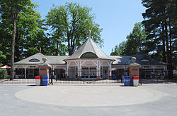
Saratoga County is extremely popular between late July and early September each year due to the Saratoga Race Course being open. This world-famous track dates back to 1863, when it was founded by John Morrissey. [26] Thoroughbred horse racing in the United States has its own Hall of Fame in Saratoga Springs, which honors remarkable horses, jockeys, owners, and trainers. Horse-racing fans come from all over to watch the races. [27]

The Saratoga National Historical Park is located along the Hudson River in Stillwater, and features a drive-around trail where one can drive up to each station. The park is also famous for its outstanding views of the area's natural scenery and Vermont's Green Mountains in the distance.

The Saratoga Spa State Park capitalizes on the culture and the mineral springs that once drove Saratoga County. This is a large state park and includes a hotel, two pool complexes, mineral baths, Saratoga Performing Arts Center, picnic areas, hiking trails, and numerous mineral springs.

Saratoga County serves as the southern gateway to the Adirondack Park, the largest park in the contiguous United States, covering about 6.1 million acres (2.5×10^6 ha), a land area roughly the size of Vermont and greater than the areas of the National Parks of Yellowstone, Grand Canyon, Glacier, and Great Smoky Mountains combined. [28] A portion of northwestern Saratoga County lies within the boundaries of the Adirondack Park and includes Hadley Mountain.

Education

Unified school districts

Colleges and universities

Communities

Cities

Towns

Villages

Census-designated places

Hamlets

Government

United States presidential election results for Saratoga County, New York [30]
Year Republican Democratic Third party
No.%No.%No.%
2020 61,30546.21%68,47151.62%2,8792.17%
2016 54,57547.83%50,91344.62%8,6067.54%
2012 50,38247.75%52,95750.19%2,1712.06%
2008 52,85547.45%56,64550.85%1,8871.69%
2004 56,15852.55%48,73045.60%1,9851.86%
2000 46,62349.05%43,35945.61%5,0755.34%
1996 34,33740.08%39,83246.50%11,49613.42%
1992 36,91741.10%33,01136.76%19,88422.14%
1988 43,49857.39%31,68441.81%6060.80%
1984 47,39467.91%22,16631.76%2280.33%
1980 34,18452.30%23,64136.17%7,53711.53%
1976 38,29661.29%23,76838.04%4220.68%
1972 40,58269.22%17,89930.53%1500.26%
1968 25,65855.87%17,76638.69%2,4985.44%
1964 13,36431.32%29,26468.57%470.11%
1960 25,03557.88%18,17942.03%360.08%
1956 32,52277.69%9,33822.31%00.00%
1952 29,71272.17%11,41327.72%430.10%
1948 20,70661.50%11,45734.03%1,5034.46%
1944 20,19759.26%13,78840.45%980.29%
1940 21,29858.46%15,03741.27%980.27%
1936 19,15355.90%14,61942.66%4941.44%
1932 17,99056.97%13,05341.34%5351.69%
1928 19,18359.60%12,24738.05%7572.35%
1924 17,68265.84%7,02626.16%2,1488.00%
1920 16,22267.99%6,90528.94%7313.06%
1916 8,06253.00%6,71144.12%4382.88%
1912 6,40143.71%5,29636.16%2,94720.12%
1908 8,70654.49%6,51840.80%7524.71%
1904 9,54658.46%6,14937.66%6343.88%
1900 9,60259.79%5,91636.84%5413.37%
1896 9,63863.57%4,98732.89%5363.54%
1892 7,38351.83%5,75540.40%1,1067.76%
1888 8,59454.36%6,57041.56%6464.09%
1884 8,19056.28%5,84640.17%5173.55%

Saratoga County is governed by a Board Of Supervisors, with each town Supervisor acting as the representative from that community. The City of Saratoga Springs elects two Supervisors and the City of Mechanicville elects one supervisor to sit on the Board of Supervisors, but have no power in their respective city governments. The Town of Clifton Park also elects two Supervisors, one being the elected Town Supervisor, and one having only County duties. Voting is by weighted vote of each of the communities based on population, which is the reason why Saratoga Springs and Clifton Park, the two largest communities in Saratoga County, elect two Supervisors. The political makeup of the 2016-17 Board consists of 21 Republicans, and two Democrats. By long-standing tradition, whoever serves as chairman of the Board of Supervisor's powerful Law and Finance Committee one year serves as chairman of the full Board the following year—a tradition that has been broken only three times in Saratoga County's history. Under this custom, current Law and Finance Committee Chairman Arthur "Mo" Wright, the Supervisor of the Town of Hadley, is slated to become chairman of the full Board in 2016.

Republicans hold the county-wide offices of Sheriff, District Attorney, County Clerk, Treasurer, and Judges of the county, Family, and the Surrogate Courts.

Saratoga County Airport, Saratoga Springs. Saratoga County Airport.jpg
Saratoga County Airport, Saratoga Springs.

On the presidential level, like most of the Hudson Valley, Saratoga County was historically powerfully Republican. It only supported a Democrat for president twice in the 20th century, in 1964 and 1996.

The Republican edge narrowed somewhat in the 1990s, and since then Saratoga County has been a Republican-leaning swing county. George W. Bush won the county narrowly in 2004 with 53% of the vote, while Barack Obama slightly edged out John McCain and Mitt Romney in both 2008 and 2012, becoming the first Democrat to win a majority in the county since 1964. In 2016, Saratoga County flipped back to the Republicans, with Donald Trump capturing a narrow plurality of the vote over Hillary Clinton. This flip proved temporary, with Democratic candidate Joe Biden winning the county in 2020. [31] Saratoga County has backed the winning candidate in every presidential election since 1996.

The county is represented in the U.S. Congress by Republican Elise Stefanik and Democrat Paul Tonko.

In the State Senate, the county is divided between Republicans Daphne Jordan and Jim Tedisco, while in the State Assembly Democrats John T. McDonald III and Carrie Woerner, along with Republicans Mary Beth Walsh and Dan Stec, each represent portions of the county.

James A. Murphy III, a Republican, is the County Court Judge and a former District Attorney.

James A. Bowen had been the dean of NYS Sheriffs, having served as Sheriff since 1972, when he was appointed by Governor Nelson A. Rockefeller. Bowen won election in his own right in 1973 and had been elected every four years up until his retirement at the end of his tenth term in office in 2013. Michael H. Zurlo is the current Sheriff, winning the election to succeed Bowen in 2013.

Democratic strength is best shown in the City of Saratoga Springs, which has voted Democratic in every presidential election since 1988. Republican strength is concentrated in the western part of the county, which is mostly rural or exurban. In 2005, the Democrats gained a majority on the Saratoga Springs City Council after decades of Republican dominance. The Republicans, however, reclaimed the council majority in the 2007 General Elections due to a split Democratic Party in the mayor's race. In 2009, the Republicans reclaimed their supermajority (4-1) on the City Council, by winning every contested election (Mayor, Finance, Public Safety, and Public Works). In 2011, Democrats reclaimed the Majority on the City Council, while Republican Scott Johnson was reelected as Mayor. The Current City Council (2016-2017)is 4-1 Democratic led by Mayor Meg Kelly. At the Saratoga County Board of Supervisors, the city is split, with one Republican and one Democrat holding the two Supervisor seats.

State Assembly

State Senate

United States House of Representatives

Notable people

See also

Notes

  1. "On February 7, 1791, taken from Albany, the county of Saratoga was organized." [34]

Related Research Articles

<span class="mw-page-title-main">Albany County, New York</span> County in New York, United States

Albany County is a county in the state of New York, United States. Its northern border is formed by the Mohawk River, at its confluence with the Hudson River, which is to the east. As of the 2020 United States Census, the population was 314,848. The county seat and largest city is Albany, which is also the state capital of New York. As originally established by the English government in the colonial era, Albany County had an indefinite amount of land, but has had an area of 530 square miles (1,400 km2) since March 3, 1888. The county is named for the Duke of York and of Albany, who became James II of England. The county is part of the Capital District region of the state.

<span class="mw-page-title-main">Washington County, New York</span> County in New York

Washington County is a county in the U.S. state of New York. As of the 2020 census, the population was 61,302. The county seat is Fort Edward. The county was named for U.S. President George Washington. The county is part of the Capital District region of the state.

<span class="mw-page-title-main">Warren County, New York</span> County in New York, United States

Warren County is a county in the U.S. state of New York. As of the 2020 census, the population was 65,737. The county seat is Queensbury. The county was established in 1813 and is named in honor of General Joseph Warren, an American Revolutionary War hero of the Battle of Bunker Hill. The county is part of the Capital District region of the state.

<span class="mw-page-title-main">Rensselaer County, New York</span> County in New York, United States

Rensselaer County is a county in the U.S. state of New York. As of the 2020 census, the population was 161,130. Its county seat is Troy. The county is named in honor of the family of Kiliaen van Rensselaer, the original Dutch owner of the land in the area. The county is part of the Capital District region of the state.

<span class="mw-page-title-main">Oneida County, New York</span> County in New York, United States

Oneida County is a county in the state of New York, United States. As of February 26, 2024, the population was 226,654. The county seat is Utica. The name is in honor of the Oneida, one of the Five Nations of the Iroquois League or Haudenosaunee, which had long occupied this territory at the time of European encounter and colonization. The federally recognized Oneida Indian Nation has had a reservation in the region since the late 18th century, after the American Revolutionary War. The county is part of the Mohawk Valley region of the state.

<span class="mw-page-title-main">Schenectady County, New York</span> County in New York, United States

Schenectady County is a county in the U.S. state of New York. As of the 2020 census, the population was 158,061. The county seat is Schenectady. The name is from a Mohawk language word meaning "on the other side of the pine lands," a term that originally applied to Albany. The county is part of the Capital District region of the state.

<span class="mw-page-title-main">Interstate 87 (New York)</span> Interstate Highway in eastern New York

Interstate 87 (I-87) is a 333.49-mile-long (536.70 km) north–south Interstate Highway located entirely within the US state of New York. I-87 is the main highway that connects New York City and Montreal. The highway begins at exit 47 off I-278 in the New York City borough of the Bronx, just north of the Robert F. Kennedy Bridge and Grand Central Parkway. From there, the route runs northward through the Hudson Valley, the Capital District, and the easternmost part of the North Country to the Canada–United States border in the town of Champlain. At its north end, I-87 continues into Quebec as Autoroute 15 (A-15). I-87 connects with several regionally important roads: I-95 in New York City, New York State Route 17 near Harriman, I-84 near Newburgh, and I-90 in Albany. The highway is not contiguous with I-87 in North Carolina.

<span class="mw-page-title-main">Ballston, New York</span> Town in New York, United States

Ballston is a town in Saratoga County, New York, United States. The population was 11,831 at the 2020 census. The name is derived from an early settler, Eliphalet Ball, a Presbyterian minister who relocated there from Westchester County, New York in 1770. The town is in the southern part of the county, and is north of Schenectady.

<span class="mw-page-title-main">Ballston Spa, New York</span> Village in New York, United States

Ballston Spa is a village and the county seat of Saratoga County, New York, United States, located southwest of Saratoga Springs. It is part of the Capital Region. The population of the village, named after Rev. Eliphalet Ball, a Congregationalist clergyman and an early settler, was 5,111 at the 2020 census. Ballston Spa lies on the border of two towns, situated partly in the Town of Ballston and partly in the Town of Milton. The Ballston Spa School District encompassing most of the combined towns of Milton, Malta, and Ballston is often referred to locally as ‘Ballston Spa’ with the village proper being referred to as ‘The Village’ or 'Town'.

<span class="mw-page-title-main">Clifton Park, New York</span> Town in New York, United States

Clifton Park is a suburban town in Saratoga County, New York, United States. It is the largest municipality in the county, with a 2020 population of 38,029, according to the 2020 census. The name is derived from an early land patent. The town is in the southern part of Saratoga County, approximately 12 miles (19 km) north of Albany, 7 miles (11 km) northeast of Schenectady, and 10 miles (16 km) south of Saratoga Springs.

<span class="mw-page-title-main">Halfmoon, New York</span> Town in New York, United States

Halfmoon is a town in Saratoga County, New York, United States. The population was 25,662 at the 2020 census. The town is apparently named for the shape of the lower elevation land north of the junction of the Hudson and Mohawk Rivers. It is also said to be named for Henry Hudson's ship, the Halve Maen.

<span class="mw-page-title-main">Malta, New York</span> Town in New York, United States

Malta is a town in Saratoga County, New York, United States. The town is in the central part of the county and is south of Saratoga Springs. The population was 17,130 as of the 2020 census.

<span class="mw-page-title-main">Round Lake (village), New York</span> Village in New York, United States

Round Lake is a village in Saratoga County, New York, United States. The population was 1,245 at the 2020 census. The name is derived from a circular lake adjacent to the village. In 1975, the Round Lake Historic District, which encompasses the village, was added to the National Register of Historic Places.

<span class="mw-page-title-main">Saratoga Springs, New York</span> City in New York, United States

Saratoga Springs is a city in Saratoga County, New York, United States. The population was 28,491 at the 2020 census. The name reflects the presence of mineral springs in the area, which has made Saratoga a popular resort destination for over 200 years. It is home to the Saratoga Race Course, a thoroughbred horse racing track, and Saratoga Performing Arts Center, a music and dance venue. The city's official slogan is "Health, History, and Horses".

<span class="mw-page-title-main">Wilton, New York</span> Town in New York, United States

Wilton is a town in Saratoga County, New York, United States. The population was 17,361 at the 2020 census.

<span class="mw-page-title-main">Colonie, New York</span> Town in New York, United States

Colonie is a town in Albany County, New York, United States. It is the most-populous suburb of Albany, and is the third-largest town in area in Albany County, occupying approximately 11% of the county. Several hamlets exist within the town. As of the 2020 census, the town had a total population of 85,590.

<span class="mw-page-title-main">Capital District (New York)</span> Region in New York, United States

The Capital District, also known as the Capital Region, is the metropolitan area surrounding Albany, the capital of the U.S. state of New York. The Capital District was first settled by the Dutch in the early 17th century and came under English control in 1664. Albany has been the permanent capital of the state of New York since 1797. The Capital District is notable for many historical events that predate the independence of the United States, including the Albany Plan of Union and the Battles of Saratoga.

<span class="mw-page-title-main">New York State Route 50</span> State highway in New York, US

New York State Route 50 (NY 50) is a 31.67-mile (50.97 km) state highway in the Capital District of New York in the United States. The southern terminus of the route is at an intersection with NY 5 in Scotia. Its northern terminus is at a junction with NY 32 in the Saratoga County hamlet of Gansevoort.

<span class="mw-page-title-main">U.S. Route 9 in New York</span> Longest north–south U.S. Highway in New York

U.S. Route 9 (US 9) is a part of the United States Numbered Highway System that runs from Laurel, Delaware, to Champlain, New York. In New York, US 9 extends 324.72 miles (522.59 km) from the George Washington Bridge in Manhattan to an interchange with Interstate 87 (I-87) just south of the Canadian border in the town of Champlain. US 9 is the longest north–south U.S. Highway in New York. The portion of US 9 in New York accounts for more than half of the highway's total length.

<span class="mw-page-title-main">Tech Valley</span> Region in New York, United States

Tech Valley began as a marketing name for the eastern part of the U.S. state of New York, encompassing the Capital District and the Hudson Valley. Originating in 1998 to promote the greater Albany area as a high-tech competitor to regions such as Silicon Valley and Boston, the moniker subsequently grew to represent the counties in New York between IBM's Westchester County plants in the south and the Canada–United States border to the north, and has since evolved to constitute both the technologically oriented metonym and the geographic territory comprising most of New York State north of New York City. The area's high technology ecosystem is supported by technologically focused academic institutions including Rensselaer Polytechnic Institute and the State University of New York Polytechnic Institute.

References

  1. 1 2 3 4 "State & County QuickFacts - Saratoga County, New York". United States Census Bureau . Retrieved June 5, 2023.
  2. "US Census 2020 Population Dataset Tables for New York". United States Census Bureau. Retrieved January 2, 2022.
  3. 1 2 "Fun Facts About Saratoga". Saratoga County Chamber of Commerce. Archived from the original on April 3, 2015. Retrieved March 29, 2015.
  4. "New Census data show Saratoga County fastest growing in upstate". August 12, 2021.
  5. "Annual Estimates of the Resident Population: April 1, 2010 to July 1, 2018 - 2018 Population Estimates". United States Census Bureau. Archived from the original on February 13, 2020. Retrieved March 26, 2018.
  6. "Find a County". National Association of Counties. Archived from the original on May 31, 2011. Retrieved March 16, 2015.
  7. 1 2 Keshia Clukey (June 27, 2014). "Better than advertised: Chip plant beats expectations". Albany Business Review. Archived from the original on July 22, 2015. Retrieved July 20, 2015.
  8. 1 2 Freeman Klopott; Xu Wang & Niamh Ring (September 27, 2011). "IBM, Intel Start $4.4 Billion in Chip Venture in New York". 2011 Bloomberg. Archived from the original on September 30, 2011. Retrieved July 12, 2015.
  9. 1 2 3 Larry Rulison (July 10, 2015). "Made in Albany: IBM reveals breakthrough chip made at SUNY Poly". Albany Times-Union. Archived from the original on July 12, 2015. Retrieved July 12, 2015.
  10. "GLOBALFOUNDRIES Moves Corporate Headquarters to its Most Advanced Semiconductor Manufacturing Facility in New York | GlobalFoundries". globalfoundries.com. April 26, 2021. Retrieved May 19, 2021.
  11. Starr, Timothy (2008). Invented in Saratoga County. New York: Rock City Falls.
  12. "Saratoga County, New York". Archived from the original on March 25, 2015. Retrieved March 28, 2015.
  13. "2010 Census Gazetteer Files". United States Census Bureau. August 22, 2012. Archived from the original on May 19, 2014. Retrieved January 7, 2015.
  14. "U.S. Decennial Census". United States Census Bureau. Retrieved January 7, 2015.
  15. "Historical Census Browser". University of Virginia Library. Archived from the original on August 11, 2012. Retrieved January 7, 2015.
  16. "Population of Counties by Decennial Census: 1900 to 1990". United States Census Bureau. Archived from the original on February 19, 2015. Retrieved January 7, 2015.
  17. "Census 2000 PHC-T-4. Ranking Tables for Counties: 1990 and 2000" (PDF). United States Census Bureau. Archived (PDF) from the original on December 18, 2014. Retrieved January 7, 2015.
  18. Population Growth Archived 2007-07-14 at the Wayback Machine . CensusScope. Retrieved on 2013-08-16.
  19. "P2 HISPANIC OR LATINO, AND NOT HISPANIC OR LATINO BY RACE – 2020: DEC Redistricting Data (PL 94-171) – Saratoga County, New York".
  20. "Profile of General Population and Housing Characteristics: 2010 Demographic Profile Data". United States Census Bureau. Archived from the original on February 12, 2020. Retrieved March 28, 2015.
  21. "State & County QuickFacts - Saratoga County, New York QuickLinks - American Community Survey: Economic Characteristics - Selected Economic Characteristics - 2009-2013 American Community Survey 5-Year Estimates". United States Census Bureau. Archived from the original on April 2, 2015. Retrieved March 28, 2015.
  22. Saratoga County Public and Private Airports, New York Archived 2014-04-22 at the Wayback Machine . Retrieved June 13, 2013.
  23. 1 2 "About Tech Valley". Tech Valley Chamber Coalition. Archived from the original on November 3, 2008. Retrieved September 27, 2009.
  24. "Fab 8 Overview". GLOBALFOUNDRIES Inc. Archived from the original on July 13, 2015. Retrieved July 12, 2015.
  25. 1 2 "2020 Annual report" (PDF). Adirondeck Trust. December 31, 2020. Retrieved October 27, 2021.
  26. "History of Saratoga Race Track | Saratoga Race Track". www.leagueathletics.com. Retrieved January 21, 2021.
  27. "Saratoga Race Course". www.nyra.com. Retrieved January 21, 2021.
  28. "Largest Park Area in the Contiguous US Remains Open to Visitors". Regional Office of Sustainable Tourism / Lake Placid CVB. October 3, 2013. Archived from the original on March 29, 2015. Retrieved March 28, 2015.
  29. "Saratoga County School Districts – Saratoga County New York".
  30. Leip, David. "Dave Leip's Atlas of U.S. Presidential Elections". uselectionatlas.org. Archived from the original on March 23, 2018. Retrieved May 1, 2018.
  31. Munson, By Emilie (November 18, 2020). "Biden wins GOP-rich Rensselaer and Saratoga counties". Times Union.
  32. "Scott Underwood of Train". November 14, 2011.
  33. 1 2 "Saratoga Legends: Famous Products, People, and Films from Saratoga, NY".
  34. Sullivan, James; Williams, Melvin E.; Conklin, Edwin P.; Fitzpatrick, Benedict, eds. (1927). "Chapter VIII. Saratoga County.". History of New York State, 1523–1927 (PDF). Vol. 2. New York City, Chicago: Lewis Historical Publishing Co. p. 470. hdl:2027/mdp.39015019994048. Wikidata   Q114149636.

Further reading

43°07′N73°52′W / 43.11°N 73.87°W / 43.11; -73.87