
The Erie Canal is a historic canal in upstate New York that runs east–west between the Hudson River and Lake Erie. Completed in 1825, the canal was the first navigable waterway connecting the Atlantic Ocean to the Great Lakes, vastly reducing the costs of transporting people and goods across the Appalachians. In effect, the canal accelerated the settlement of the Great Lakes region, the westward expansion of the United States, and the economic ascendancy of New York State. It has been called "The Nation's First Superhighway."

Montezuma is a town in Cayuga County, New York, United States. The population was 1,277 at the 2010 census.
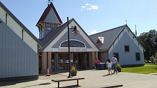
Clifton Park is a suburban town in Saratoga County, New York, United States. According to the United States Census Bureau, the 2020 population was 38,029. The name is derived from an early land patent. The town is in the southern part of Saratoga County, approximately 12 miles (19 km) north of Albany, 7 miles (11 km) northeast of Schenectady, and 10 miles (16 km) south of Saratoga Springs.
Halfmoon is a town in Saratoga County, New York, United States. The population was 25,662 at the 2020 census. The town is apparently named for the shape of the lower elevation land north of the junction of the Hudson and Mohawk Rivers. It is also said to be named for Henry Hudson's ship, the Halve Maen.

Waterford is a village in Saratoga County, New York, United States. The population was 1,990 at the 2010 census. The name derives from the ford between the mainland and Peebles Island.

Waterford is a town in Saratoga County, New York, United States. The population was 8,423 at the 2010 census. The name of the town is derived from its principal village, also called Waterford. The town is located in the southeast corner of Saratoga County and north-northwest of Troy at the junction of the Erie Canal and the Hudson River.

The Ohio and Erie Canal was a canal constructed during the 1820s and early 1830s in Ohio. It connected Akron with the Cuyahoga River near its outlet on Lake Erie in Cleveland, and a few years later, with the Ohio River near Portsmouth. It also had connections to other canal systems in Pennsylvania.
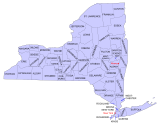
Buildings, sites, districts, and objects in New York listed on the National Register of Historic Places:
Rexford is a hamlet in Saratoga County, New York, United States, located on the north bank of the Mohawk River. Rexford is in the Town of Clifton Park, near the southwestern town line. Its boundaries, like those of neighboring Alplaus, are unofficial and necessarily ambiguous. To the south, it is bounded by the Mohawk River and Grooms Road and to the west, Alplaus and the Schenectady County line. Route 146 and Vischer's Ferry Road, are probably a reasonable delineations of its northern and eastern boundaries. The ZIP Code is 12148.

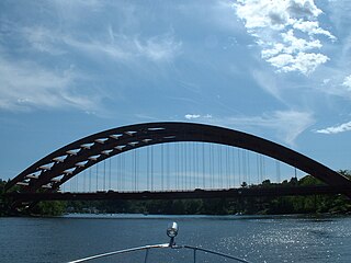
Bridge 8, known locally as the Rexford Bridge, is a two-lane bridge crossing the Mohawk River northeast of the city of Schenectady in New York, United States. It carries New York State Route 146 (NY 146) from Schenectady County to Rexford, a hamlet in the Saratoga County town of Clifton Park. The bridge was designed by the New York State Department of Public Works and opened in 1965. It has a total length of 727 feet (222 m) and a main span of 266 feet (81 m).
Dunsbach Ferry is a hamlet of the town of Colonie, in Albany County, New York, United States. The hamlet sits to the east of, and below, the Thaddeus Kosciusko Bridge, where Interstate 87 (I-87) crosses the Mohawk River. There are numerous private and public docks and landings between the Twin Bridges and the Colonie Town Park. Dunsbach Ferry was once an important river crossing and a stop on the Schenectady and Troy Railroad (T&S), later a branch of the New York Central Railroad. The ZIP code is 12047 (Cohoes).

Crescent Bridge is a 1,229-foot (375 m) bridge over the Mohawk River and the Erie Canal. It is in Crescent, New York, a hamlet in the town of Halfmoon in southern Saratoga County on the northern side of the Mohawk River. The Crescent Bridge carries U.S Route 9 over the Mohawk River between the towns of Colonie in Albany County and Halfmoon.

Barryville is a hamlet in Highland, Sullivan County, New York, United States. Previously known as "The River," the hamlet was renamed for William T. Barry, postmaster general under President Andrew Jackson.
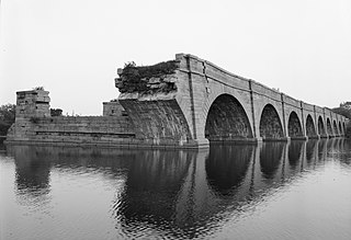
Schoharie Crossing State Historic Site, also known as Erie Canal National Historic Landmark, is a historic district that includes the ruins of the Erie Canal aqueduct over Schoharie Creek, and a 3.5-mile (5.6 km) long part of the Erie Canal, in the towns of Glen and Florida within Montgomery County, New York. It was the first part of the old canal to be designated a National Historic Landmark, prior to the designation of the entire New York State Barge Canal as an NHL in 2017.

New York State Route 146B (NY 146B) was a state highway in southern Saratoga County, New York, in the United States. It was 3 miles (4.8 km) long and located entirely within the town of Clifton Park. The western terminus of the route was at an intersection with NY 146, its parent route, in the hamlet of Rexford. The eastern terminus of NY 146B was in the hamlet of Groom Corners, where it met Miller and Sugarhill roads. NY 146B was assigned c. 1932 and removed c. 1965. Its former routing is now the western portion of County Route 91 (CR 91).

The Mohawk Towpath Scenic Byway is a National Scenic Byway in the Capital District region of New York in the United States. It extends from Schenectady to Waterford by way of a series of local, county, and state highways along the Mohawk River and the Erie Canal. The byway is intended to showcase the history of the waterway, from Native American times through the creation of the Erie Canal and the role the waterside communities played in the Industrial Revolution and the westward expansion of the United States. At its east end, the byway connects to the Lakes to Locks Passage, an All-American Road.

Vischer Ferry is a hamlet in the town of Clifton Park in Saratoga County, New York, United States, along the Mohawk River.
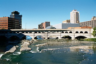
Erie Canal: Second Genesee Aqueduct, also known as the Broad Street Aqueduct or Broad Street Bridge, is a historic stone aqueduct located at Rochester in Monroe County, New York. It was constructed in 1836–1842 and originally carried the Erie Canal over the Genesee River. The overall length of the aqueduct including the wings and abutments is 800 feet (240 m). The aqueduct is 70 feet (21 m) wide and has large parapets on either side. It is one of four major aqueducts in the mid-19th century Erie Canal system. In 1927, a roadbed was added to carry automobile traffic and named Broad Street. It also carried a part of the Rochester Subway.
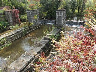
Centreport Aqueduct is a historic aqueduct located in the town of Brutus near Weedsport in Cayuga County, New York. The aqueduct was constructed in 1854-1857 as a part of the Weedsport section of the "Improved Erie Canal." The wood and stone aqueduct carried the Erie Canal over Cold Spring Brook near its juncture with North Brook. The aqueduct structure is approximately 125 feet in length, 125 feet in width, and 16 feet in height. Improvements were made to the aqueduct in 1895 as part of the "Nine Million Dollar Improvement." The aqueduct ceased being used after development of the New York State Barge Canal System in 1917. The aqueduct stone work is still intact and is the prime feature of a roadside park constructed by the New York State Department of Transportation in 1972 with the assistance of the Weedsport Lions Club.

Aqueduct is a hamlet in the Town of Niskayuna, Schenectady County, New York, United States. Its center is at the south end of the bridge of New York State Route 146 over the Mohawk River, that connects Schenectady County to the south and Saratoga County to the north. It was formerly a transportation hub. Alexander's Bridge across the Mohawk antedated the Aqueduct. A new Route 146 steel highway bridge, with board pavement, parallel to the Aqueduct was built in the early 20th century. A Schenectady trolley line ended there, the line also serving Luna Park, just over the river in Rexford. There was, in Aqueduct, a staffed station of the Troy & Schenectady Railroad, which operated from 1841 to 1932.


