Corinth, New York

Last updated

Corinth
Kahcheboncook (Mohawk)
Town of Corinth
Corinth, New York businesses.jpg
Main Street, Corinth NY
Nickname: 
Gateway to the Adirondacks
Corinth NY Locator Map.png
Map highlighting Corinth's location within Saratoga County.
USA New York location map.svg
Red pog.svg
Corinth
Location of Corinth in New York
Coordinates: 43°13′36″N73°53′23″W / 43.22667°N 73.88972°W / 43.22667; -73.88972
Country United States
State New York
County Saratoga
Settled1775
Established1818
Area
[1]
  Total58.13 sq mi (150.57 km2)
  Land56.76 sq mi (147.02 km2)
  Water1.37 sq mi (3.55 km2)
Population
 (2010) [2]
  Total6,531
  Estimate 
(2016) [3]
6,394
  Density112.64/sq mi (43.49/km2)
Time zone UTC-5 (Eastern (EST))
  Summer (DST) UTC-4 (EDT)
Area code 518
FIPS code 36-091-18223
Website www.townofcorinthny.com
Perspective map of Corinth and Palmer Falls by L.R. Burleigh from 1888 with a list of landmarks 1888 Corinth, N.Y. and Palmer Falls. LOC 75694762.jpg
Perspective map of Corinth and Palmer Falls by L.R. Burleigh from 1888 with a list of landmarks

Corinth is a town in Saratoga County, New York, United States. The population was 6,531 at the 2010 census. [2] The town contains a village also named Corinth. The town is on the northeastern border of the county, north of Saratoga Springs. The town is noted as "the snowshoe capital of the world" [4] and is home to Palmer Falls where the Hudson River passes through the Palmertown Range.

Contents

History

Palmer Falls c.1930-1945 Palmer Falls, Corinth NY.jpg
Palmer Falls c.1930-1945

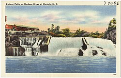
Palmer Falls is an area of whitewater waterfalls formerly known as "Kah-che-bon-cook", "Hadley Falls", "The Great Falls of the Hudson", or "Palmer's Great Falls". [5] The falls are now named after Beriah Palmer, who at one time owned land along both sides of the river by the falls.

Around 1763, after the French and Indian War, Ebenezer Jessup and his brother Edward from Luzerne began lumbering operations in the area. They floated rafts of logs down the Hudson and bypassed Palmer Falls by landing the rafts at a place called "Jessup's Landing", now the public beach of the Village of Corinth, where they loaded the logs onto wagons and carted them around the falls. [5] During the American Revolution the Jessups sided with the Loyalists and fled to Canada, where they commanded a unit known as "Jessup's Loyal Rangers". [6] For a long time the area was known as Jessup's Landing. The first permanent settlement in this area was around 1777, when Joseph Eggleston moved from Wilton to escape British raiders. John W. Taylor moved from Charlton to Jessup's Landing around 1808 and helped organize the Town of Corinth in 1818. [7]

Around 1790 Ambrose Clothier moved from Connecticut and built a cabin near Lake Bonita on Mount McGregor. [8] He had three sons and three daughters, and all his sons were noted fiddlers. The area around Beaver Brook near the Hudson is today known as "Clothier Hollow".Other early settlers in this area were Benjamin Ide, Jonathan Hodges, William Grippen, Lawrence Barber, Jonathan Barrass, and Hathaway Randall. [7]

A third area of settlement was South Corinth (originally Chapman's Corners) along the Kayaderosseras Creek near the border with Greenfield. This area was settled around 1788 by Adam Comstock from Warwick, Rhode Island, who served in the New York State Assembly from 1792 to 1840, and the New York State Senate from 1805 to 1808. Other early settlers were Benjamin Carpenter, Nathaniel Edwards, Frederick Parkman, Jeremiah Eddy, John Purqua, and Washington Chapman. [9]

The town was formed in 1818 from the town of Hadley. The first business was to decide on a name. Mrs. Washington Chapman was allowed to choose the name. She opened her bible randomly to the Epistle to the Corinthians, so the town became Corinth. [9] :p.394

Lumbering was important to the early town, which had more than thirty sawmills. After the American Civil War, many paper mills opened in the town.

In 1888, the hamlet of Corinth incorporated as a village. L.R. Burleigh published a perspective map of Corinth and Palmer Falls in 1888 along with an identifying list of landmarks.

Geography

According to the United States Census Bureau, the town has a total area of 58.1 square miles (150.6 km2), of which 56.8 square miles (147.1 km2) is land and 1.3 square miles (3.4 km2) (2.29%) is water.

The eastern town line, formed by the Hudson River, is the border of Warren County. The western part of the town is in the Adirondack Park.

Transportation

New York State Route 9N is a north-south highway.

The Saratoga and North Creek Railway used to stop in Corinth once daily northbound and southbound on Saturday and Sunday in May and June, and Friday through Tuesday in July through October. The branch line shut down in 2002 along with the paper mill's closure.

Industry

As early as 1804, a sawmill was established on the Hudson at Palmer Falls, followed shortly by a gristmill and a woolen factory. In 1869, the Hudson River Pulp & Paper Company established its mill and in 1870 began to produce paper from the pulp. [9] This "Hudson River Mill" became the flagship of the International Paper Company at its founding in 1898, and at times had over 1500 employees. The mill specialized in the production of coated paper until its closure in 2002. A shirt factory was established in Corinth in the 1890s and was purchased by Cluett Peabody & Company in 1899. [7] The factory closed in 1975. The Elixman Paper Core Company operated in the village from 1913 until its closure in 1976. [10] Other industries included a sawmill and excelsior plant, a chair factory, and a sand, crushed-stone, and gravel operation. [7]

In 1805, Washington Chapman built a woolen mill in South Corinth, which was later converted to producing nuts and bolts. The hamlet was the site of a tannery, built in 1855 which, by the 1870s, processed five thousand hides a year. Two sawmills nearby produced two thousand cords of hemlock bark and two million feet of lumber annually. [9]

Demographics

Historical population
CensusPop.Note
1820 1,490
1830 1,412−5.2%
1840 1,365−3.3%
1850 1,50110.0%
1860 1,5583.8%
1870 1,500−3.7%
1880 1,73715.8%
1890 2,12422.3%
1900 3,10446.1%
1910 3,102−0.1%
1920 3,69619.1%
1930 3,7601.7%
1940 4,47819.1%
1950 4,8799.0%
1960 5,1675.9%
1970 5,4425.3%
1980 5,216−4.2%
1990 5,93513.8%
2000 5,9850.8%
2010 6,5319.1%
2016 (est.)6,394 [3] −2.1%
U.S. Decennial Census [11]

As of the census [2] of 2000, there were 5,985 people, 2,331 households, and 1,662 families residing in the town. The population density was 105.4 inhabitants per square mile (40.7/km2). There were 2,804 housing units at an average density of 49.4 per square mile (19.1/km2). The racial makeup of the town was 98.28% White, 0.20% Black or African American, 0.15% Native American, 0.20% Asian, 0.10% Pacific Islander, 0.30% from other races, and 0.77% from two or more races. Hispanic or Latino of any race were 0.79% of the population.

There were 2,331 households, out of which 32.6% had children under the age of 18 living with them, 55.2% were married couples living together, 10.7% had a female householder with no husband present, and 28.7% were non-families. Of all households, 23.4% were made up of individuals, and 12.8% had someone living alone who was 65 years of age or older. The average household size was 2.57 and the average family size was 2.99.

In the town, the population was spread out, with 26.0% under the age of 18, 7.3% from 18 to 24, 28.6% from 25 to 44, 23.8% from 45 to 64, and 14.2% who were 65 years of age or older. The median age was 38 years. For every 100 females, there were 96.6 males. For every 100 females age 18 and over, there were 94.0 males.

The median income for a household in the town was $35,199, and the median income for a family was $41,732. Males had a median income of $32,227 versus $25,146 for females. The per capita income for the town was $16,003. About 7.8% of families and 11.9% of the population were below the poverty line, including 14.7% of those under age 18 and 6.4% of those age 65 or over.

Communities and locations

Related Research Articles

<span class="mw-page-title-main">Warren County, New York</span> County in New York, United States

Warren County is a county in the U.S. state of New York. As of the 2020 census, the population was 65,737. The county seat is Queensbury. The county was established in 1813 and is named in honor of General Joseph Warren, an American Revolutionary War hero of the Battle of Bunker Hill.

<span class="mw-page-title-main">Black Brook, New York</span> Town in New York, United States

Black Brook is a town in Clinton County, New York, United States. The population was 1,497 at the 2010 census. It is named after a stream that flows through the town.

<span class="mw-page-title-main">Keene, New York</span> Town in New York, United States

Keene is a town in central Essex County, New York, United States. It includes the hamlets of Keene, Keene Valley, and St. Huberts, with a total population of 1,144 as of the 2020 census

<span class="mw-page-title-main">Hope, New York</span> Town in New York, United States

Hope is a town in Hamilton County, New York, United States. The population was 403 at the 2010 census.

<span class="mw-page-title-main">Lake Pleasant, New York</span> Town in New York, United States

Lake Pleasant is a town in Hamilton County, New York, United States. The population was 897 at the 2020 census. It contains the hamlet of Lake Pleasant, the county seat of Hamilton County.

<span class="mw-page-title-main">Greenfield, New York</span> Town in New York, United States

Greenfield is a town in Saratoga County, New York, United States. It is located northwest of Saratoga Springs, and is the largest by area in the county. Students living in Greenfield attend schools of the Saratoga Springs City School District. The Palmertown, and Kayaderosseras Ranges pass through the town, the town is located at the foothills of the Adirondack Mountains.

<span class="mw-page-title-main">Hadley, New York</span> Town in New York, United States

Hadley is a town in Saratoga County, New York, United States. The population was 1,971 at the 2000 census. The town was named after Hadley, Massachusetts.

<span class="mw-page-title-main">Moreau, New York</span> Town in New York, United States

Moreau is a town in Saratoga County, New York, United States. The population was 13,826 at the 2000 census. The town is located in the northeast part of the county, north of Saratoga Springs. Moreau is named after Jean Victor Moreau, a French general, who visited the area just before the town was formed. The town contains a village called South Glens Falls.

<span class="mw-page-title-main">Saratoga, New York</span> Town in New York, United States

Saratoga is a town in Saratoga County, New York, United States. The population was 5,141 at the 2000 census. It is also the commonly used, but not official, name for the neighboring and much more populous city, Saratoga Springs. The major village in the town of Saratoga is Schuylerville, which is often, but not officially, called Old Saratoga. Saratoga contains a second village, named Victory.

<span class="mw-page-title-main">Bolton, New York</span> Administrative divisions of New York#Village in the United States

Bolton is a town in Warren County, New York, United States. It is part of the Glens Falls Metropolitan Statistical Area. The population was 2,117 at the 2000 census. Bolton is on the eastern border of the county.

<span class="mw-page-title-main">Lake Luzerne, New York</span> Town in New York, United States

Lake Luzerne, formerly the Town of Fairfield and then Luzerne, is a town in southern Warren County, New York, United States. The town is located within the Adirondack Park. The town is part of the Glens Falls Metropolitan Statistical Area. Lake Luzerne is west of the city of Glens Falls. The town population was 3,079 at the 2020 census.

<span class="mw-page-title-main">Hudson Falls, New York</span> Village in New York, United States

Hudson Falls is a village located in Washington County, New York, United States. The village is in the southwest of the town of Kingsbury, on U.S. Route 4. Hudson Falls is part of the Glens Falls Metropolitan Statistical Area. As of the 2010 census, the village had a population of 7,281. It was the county seat of Washington County until 1994, when the county seat was moved to Fort Edward.

<span class="mw-page-title-main">Kingsbury, New York</span> Hamlet in the state of New York, United States

Kingsbury is a town in western Washington County, New York, United States. It is part of the Glens Falls Metropolitan Statistical Area. The town population was 11,171 at the 2000 census.

<span class="mw-page-title-main">Keeseville, New York</span> Hamlet and CDP in New York, United States

Keeseville is a hamlet in Clinton and Essex counties, New York, United States. The population was 1,815 at the 2010 census. The hamlet was named after the Keese family, early settlers from Vermont. It developed along the Ausable River, which provided water power for mills and industrial development.

<span class="mw-page-title-main">Corinth (village), New York</span> Village in New York, United States

Corinth is a village in Saratoga County, New York, United States. The population was 2,559 at the 2010 census. The village takes its name from the Greek city of Corinth.

<span class="mw-page-title-main">Milton, Saratoga County, New York</span> Town in New York, United States

Milton is a town in Saratoga County, New York, United States. The population was 17,103 at the 2000 census. Some believe that the town was named after the poet, John Milton, while other sources state that it is a shortening of "Mill-town" for the early mill activity.

<span class="mw-page-title-main">Stillwater, New York</span> Town in New York, United States

Stillwater is a town in Saratoga County, New York, United States, with a population of 8,287 at the 2010 census. The town contains a village called Stillwater. The town is at the eastern border of the county, southeast of Saratoga Springs and borders both Rensselaer and Washington counties. Saratoga National Historical Park is located within the town's limits. There is a hamlet in Minerva, Essex County, New York, with the same name which has nothing to do with this town.

<span class="mw-page-title-main">New York State Route 9N</span> Highway in New York, USA

New York State Route 9N (NY 9N) is a north–south state highway in northeastern New York in the United States. It extends from an intersection with U.S. Route 9 (US 9), NY 29, and NY 50 in the city of Saratoga Springs to a junction with US 9 and NY 22 in the Clinton County hamlet of Keeseville. At 143.49 miles (230.92 km) in total length, NY 9N is the longest letter-suffixed route in the state. It is concurrent with its parent route for 1 mile (1.6 km) in the village of Lake George and for three blocks in the hamlet of Elizabethtown.

<span class="mw-page-title-main">Fort Edward, New York</span> Town in New York, United States

Fort Edward is a town and the county seat of Washington County, New York, United States. The population was 5,991 at the 2020 census. The municipal center complex is on U.S. Route 4 between the villages of Hudson Falls and Fort Edward. When construction of the complex was completed in 1994, most of the administrative offices were moved from the original county seat of Hudson Falls to this location. The town of Fort Edward is part of the Glens Falls Metropolitan Statistical Area.

<span class="mw-page-title-main">Greenwich (town), New York</span> Town in New York, United States

Greenwich is a town in the southwestern part of Washington County, New York, United States. The town is located on the western border of the county. The population was 4,896 at the 2000 census. It is part of the Glens Falls Metropolitan Statistical Area. Greenwich features several homes that were a part of the Underground Railroad.

References

  1. "2016 U.S. Gazetteer Files". United States Census Bureau. Retrieved July 5, 2017.
  2. 1 2 3 "U.S. Census website". United States Census Bureau . Retrieved January 31, 2008.
  3. 1 2 "Population and Housing Unit Estimates" . Retrieved June 9, 2017.
  4. "Town of Corinth". Saratoga County New York. Saratoga County. Retrieved June 2, 2016.
  5. 1 2 Lourie, Peter (1995). River of Mountains: A Canoe Journey Down the Hudson. Syracuse University Press. p. 127. ISBN   0-8156-0315-0 . Retrieved June 2, 2016.
  6. Willig, Susan L. Rootsweb http://archiver.rootsweb.ancestry.com/th/read/NY-WARWASHSAR/2002-08/1028332010 . Retrieved June 2, 2016.{{cite web}}: Missing or empty |title= (help)
  7. 1 2 3 4 Dunn, Violet B. (1974). Saratoga County Heritage. Saratoga County.
  8. Shorey, Mabel Pitkin (1959). The Early History of Corinth. The Journal Press. p. 66.
  9. 1 2 3 4 Sylvester, Nathaniel Bartlett (1878). History of Saratoga County, New York. Everts & Ensign. p.  394 . Retrieved June 1, 2016.
  10. Clothier, Rachel (2009). Corinth. Arcadia Publishing. ISBN   978-0-7385-6574-3 . Retrieved June 6, 2016.
  11. "Census of Population and Housing". Census.gov. Retrieved June 4, 2015.