Providence, New York

Last updated

Providence
Town of Providence
Providence NY Locator Map.png
Map highlighting Providence's location within Saratoga County.
New York Adirondack.svg
Red pog.svg
Providence
Location within the state of New York
Coordinates: 43°6′15″N74°3′9″W / 43.10417°N 74.05250°W / 43.10417; -74.05250
Country United States
State New York
County Saratoga
Area
[1]
  Total45.09 sq mi (116.79 km2)
  Land44.00 sq mi (113.95 km2)
  Water1.10 sq mi (2.84 km2)
Elevation
1,457 ft (444 m)
Population
 (2010)
  Total1,995
  Estimate 
(2016) [2]
2,029
  Density46.12/sq mi (17.81/km2)
Time zone UTC-5 (Eastern (EST))
  Summer (DST) UTC-4 (EDT)
ZIP code
12850
Area code 518
FIPS code 36-59949
GNIS feature ID0979400

Providence is a town in Saratoga County, New York, United States. The Town of Providence is on the county's western border and is northwest of Saratoga Springs. More than half the town is located within the Adirondack Park, the town also borders the Great Sacandaga Lake. [3]

Contents

History

The area was settled before 1786, but that was the year of any definite settlement, located by Hagedorns Mills.

The town was formed from part of the Town of Galway in 1796. The early economy was based on forestry with the harvesting of lumber, and the manufacture of pulpwood being important.

It is currently under consideration for a municipal wireless broadband network to be built in it.

The Packer Farm and Barkersville Store was listed on the National Register of Historic Places in 2013. [4]

Geography

According to the United States Census Bureau, the town has a total area of 45.1 square miles (117 km2), of which 44.0 square miles (114 km2) is land and 1.1 square miles (2.8 km2) (2.35%) is water.

The western town line is the border of Fulton County, New York. The northern part of the town is in the Adirondack Park, and part of the western town line is the shore of Great Sacandaga Lake.

The town is covered in rolling hills, and has many small streams and lakes. [3] Several reservoirs are located in the northeast of the town.

Demographics

Historical population
CensusPop.Note
1820 1,515
1830 1,5794.2%
1840 1,507−4.6%
1850 1,458−3.3%
1860 1,443−1.0%
1870 1,155−20.0%
1880 994−13.9%
1890 874−12.1%
1900 607−30.5%
1910 520−14.3%
1920 462−11.2%
1930 4701.7%
1940 409−13.0%
1950 369−9.8%
1960 55650.7%
1970 80344.4%
1980 1,21050.7%
1990 1,36012.4%
2000 1,84135.4%
2010 1,9958.4%
2016 (est.)2,029 [2] 1.7%
U.S. Decennial Census [5]

As of the census [6] of 2000, there were 1,841 people, 666 households, and 508 families residing in the town. The population density was 41.8 inhabitants per square mile (16.1/km2). There were 909 housing units at an average density of 20.6 per square mile (8.0/km2). The racial makeup of the town was 97.99% White, 0.71% African American, 0.11% Native American, 0.38% Asian, 0.33% from other races, and 0.49% from two or more races. Hispanic or Latino of any race were 1.30% of the population.

There were 666 households, out of which 36.8% had children under the age of 18 living with them, 65.3% were married couples living together, 6.2% had a female householder with no husband present, and 23.7% were non-families. 16.8% of all households were made up of individuals, and 5.6% had someone living alone who was 65 years of age or older. The average household size was 2.76 and the average family size was 3.12.

In the town, the population was spread out, with 27.3% under the age of 18, 5.5% from 18 to 24, 33.8% from 25 to 44, 24.4% from 45 to 64, and 9.0% who were 65 years of age or older. The median age was 37 years. For every 100 females, there were 102.8 males. For every 100 females age 18 and over, there were 101.7 males.

The median income for a household in the town was $43,194, and the median income for a family was $45,202. Males had a median income of $33,125 versus $22,833 for females. The per capita income for the town was $18,853. About 5.3% of families and 6.4% of the population were below the poverty line, including 9.5% of those under age 18 and 3.0% of those age 65 or over.

Communities and locations in Providence

Related Research Articles

<span class="mw-page-title-main">Franklin, Franklin County, New York</span> Town in New York, United States

Franklin is a town located in Franklin County, New York, United States. As of the 2010 census, the town had a population of 1,140.

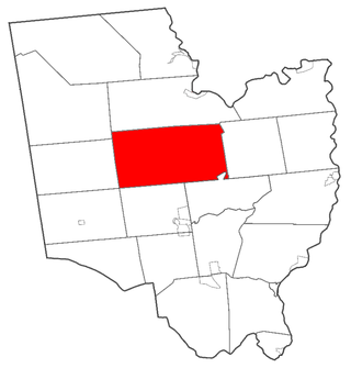
Northampton is a town in Fulton County, New York, United States. The population was 2,670 at the 2010 census. The name comes from an original land patent. Northampton is in the northeastern corner of the county and is northeast of Gloversville. The town is known for the village of Northville, a major Adirondack community; and the Great Sacandaga Lake, which composes around 40% of the town.

<span class="mw-page-title-main">Northville, Fulton County, New York</span> Village in New York, United States

Northville is a village in the northern part of the town of Northampton in Fulton County, New York, United States, northeast of Gloversville. The population was 993 at the 2020 census. It lies within Adirondack Park and serves as the southern terminus for the Northville-Placid Trail.

Oppenheim is a town in Fulton County, New York, United States. The town is in the southwestern corner of the county and is east of Utica. The population was 1,924 at the 2010 census.

<span class="mw-page-title-main">Hope, New York</span> Town in New York, United States

Hope is a town in Hamilton County, New York, United States. The population was 403 at the 2010 census.

<span class="mw-page-title-main">Lake Pleasant, New York</span> Town in New York, United States

Lake Pleasant is a town in Hamilton County, New York, United States. The population was 781 at the 2010 census. It contains the hamlet of Lake Pleasant, the county seat of Hamilton County.

<span class="mw-page-title-main">Speculator, New York</span> Village in New York, United States

Speculator is a village in Hamilton County, New York, United States. The population was 406 at the 2020 census. The 2,966-foot (904 m) Speculator Mountain rises just south of the village.

<span class="mw-page-title-main">Wells, New York</span> Town in New York, United States

Wells is a town in Hamilton County, New York, United States. The population was 674 at the 2010 census. The town is named after Joshua Wells, a land agent, who built the first mills in the area. It is in the Adirondack Park and on the eastern border of the county. It is northwest of Schenectady.

<span class="mw-page-title-main">Forestport, New York</span> Town in New York, United States

Forestport is a town in Oneida County, New York, United States. The population was 1,535 at the 2010 census.

<span class="mw-page-title-main">Day, New York</span> Town in New York, United States

Day is a town in Saratoga County, New York, United States.

<span class="mw-page-title-main">Edinburg, New York</span> Town in New York, United States

Edinburg is a town in Saratoga County, New York, United States. The town is in the North Western part of the county Saratoga Springs. The town is located entirely in the Adirondack Park. The Batchellerville Bridge crosses Great Sacandaga Lake, connecting parts of the town on either shore.

<span class="mw-page-title-main">Greenfield, New York</span> Town in New York, United States

Greenfield is a town in Saratoga County, New York, United States. It is located northwest of Saratoga Springs, and is the largest by area in the county. Students living in Greenfield attend schools of the Saratoga Springs City School District. The Palmertown, and Kayaderosseras Ranges pass through the town, the town is located at the foothills of the Adirondack Mountains.

<span class="mw-page-title-main">Hadley, New York</span> Town in New York, United States

Hadley is a town in Saratoga County, New York, United States. The population was 1,971 at the 2000 census. The town was named after Hadley, Massachusetts.

<span class="mw-page-title-main">Clifton, New York</span> Town in New York, United States

Clifton is a town in St. Lawrence County, New York, United States. The population was 675 at the 2020 census. The town takes its name from a mining company.

<span class="mw-page-title-main">Hopkinton, New York</span> Town in New York, United States

Hopkinton is a town in St. Lawrence County, New York, United States. The population was 1,105 at the 2020 census and has a Population density of 5.9 square miles. The town is named for Roswell Hopkins, a pioneer settler and a government official.

<span class="mw-page-title-main">Putnam, New York</span> Town in Washington County, New York, US

Putnam is a town in northern Washington County, New York, United States. It is part of the Glens Falls Metropolitan Statistical Area. The town population was 645 at the 2000 census. The town is named after Israel Putnam, a hero of the American Revolution.

Broadalbin is a town in Fulton County, New York, on the eastern border of the county and northwest of Albany. The town was named after the Breadalbane Region in Scotland by an early settler. The town contains a village also called Broadalbin. The population was 5,260 at the 2010 census.

<span class="mw-page-title-main">Mayfield, New York</span> Town in New York, United States

Mayfield is a town in Fulton County, New York, United States, northeast of Gloversville and Johnstown. The town contains a village also named Mayfield. The population of the town was 6,495 at the 2010 census.

<span class="mw-page-title-main">Corinth, New York</span> Town in New York, United States

Corinth is a town in Saratoga County, New York, United States. The population was 6,531 at the 2010 census. The town contains a village also named Corinth. The town is on the northeastern border of the county, north of Saratoga Springs. The town is noted as "the snowshoe capital of the world" and is home to Palmer Falls where the Hudson River passes through the Palmertown Range.

<span class="mw-page-title-main">Galway, New York</span> Town in New York, United States

Galway is a town located in Saratoga County, New York, United States. As of the 2000 census, the town had a total population of 3,589. The town contains a village also named Galway. Both the town and village are located in the western part of the county, north of Schenectady.

References

  1. "2016 U.S. Gazetteer Files". United States Census Bureau. Retrieved July 5, 2017.
  2. 1 2 "Population and Housing Unit Estimates" . Retrieved June 9, 2017.
  3. 1 2 cite web|url=https://archive.org/details/gazetteerofstate04fren/page/590/mode/2up%7Cname= Gazetter of the State of New York
  4. "National Register of Historic Places Listings". Weekly List of Actions Taken on Properties: 8/23/13 through 8/30/13. National Park Service. September 6, 2013.
  5. "Census of Population and Housing". Census.gov. Retrieved June 4, 2015.
  6. "U.S. Census website". United States Census Bureau . Retrieved January 31, 2008.