
Saratoga County is a county in the U.S. state of New York, and is the fastest-growing county in Upstate New York. As of the 2020 U.S. census, the county's population was enumerated at 235,509, its highest decennial count ever and a 7.2% increase from the 219,607 recorded at the 2010 census, representing one of the fastest growth rates in the northeastern United States; and despite the worldwide toll of the COVID-19 pandemic in the early 2020s, Saratoga County has continued its rapid growth. The county seat is Ballston Spa. The county is part of the Capital District region of the state.
Interstate 87 (I-87) is a 333.49-mile-long (536.70 km) north–south Interstate Highway located entirely within the US state of New York. I-87 is the main highway that connects New York City and Montreal. The highway begins at exit 47 off I-278 in the New York City borough of the Bronx, just north of the Robert F. Kennedy Bridge and Grand Central Parkway. From there, the route runs northward through the Hudson Valley, the Capital District, and the easternmost part of the North Country to the Canada–United States border in the town of Champlain. At its north end, I-87 continues into Quebec as Autoroute 15 (A-15). I-87 connects with several regionally important roads: I-95 in New York City, New York State Route 17 near Harriman, I-84 near Newburgh, and I-90 in Albany. The highway is not contiguous with I-87 in North Carolina.
Clifton Park is a suburban town in Saratoga County, New York, United States. It is the largest municipality in the county, with a 2020 population of 38,029, according to the 2020 census. The name is derived from an early land patent. The town is in the southern part of Saratoga County, approximately 12 miles (19 km) north of Albany, 7 miles (11 km) northeast of Schenectady, and 10 miles (16 km) south of Saratoga Springs.
Halfmoon is a town in Saratoga County, New York, United States. The population was 25,662 at the 2020 census. The town is apparently named for the shape of the lower elevation land north of the junction of the Hudson and Mohawk Rivers. It is also said to be named for Henry Hudson's ship, the Halve Maen.
Tadeusz Kościuszko was a soldier respected as a champion of liberty in both Poland and the United States.
The New York State Thruway is a system of controlled-access toll roads spanning 569.83 miles (917.05 km) within the U.S. state of New York. It is operated by the New York State Thruway Authority (NYSTA), a New York State public-benefit corporation. The 496.00-mile (798.23 km) mainline is a freeway that extends from the New York City line at Yonkers to the Pennsylvania state line at Ripley by way of I-87 and I-90 through Albany, Syracuse, and Buffalo. According to the International Bridge, Tunnel and Turnpike Association, the Thruway is the fifth-busiest toll road in the United States. The toll road is also a major route for long distance travelers linking the cities of Toronto and Buffalo with Boston and New York City.

Interstate 787 (I-787) is an auxiliary Interstate Highway in the US state of New York. I-787 is the main highway for those traveling into and out of downtown Albany. The southern terminus is, per New York traffic data, at the toll plaza for New York State Thruway (I-87) exit 23 southwest of downtown Albany. However, current signage indicates the terminus as along I-787's ramp to US Route 9W (US 9W). The northern terminus of the route is unclear, with some sources placing the terminus at 8th Street in Troy, creating an overlap with New York State Route 7 (NY 7) between Green Island and Troy. Other documents show I-787 as terminating at its interchange with NY 7 and NY 787 in the town of Colonie. Regardless, the route is 10.16 miles (16.35 km) long if extended to Troy, or 9.55 miles (15.37 km) excluding the unsigned NY 7 overlap.

Interstate 88 (I-88) is an Interstate Highway located entirely within the US state of New York. Nominally signed as an east–west road as it has an even number, it extends for 117.75 miles (189.50 km) in a northeast–southwest direction from an interchange with I-81 north of the city of Binghamton to an interchange with the New York State Thruway (I-90) west of Schenectady. The freeway serves as an important connector route from the Capital District to Binghamton, Elmira, and Scranton, Pennsylvania. I-88 closely parallels NY 7, which was once the main route through the area.

New York State Route 7 (NY 7) is a 180.30-mile-long (290.16 km) state highway in New York in the United States. The highway runs from Pennsylvania Route 29 (PA 29) at the Pennsylvania state line south of Binghamton in Broome County, New York, to Vermont Route 9 (VT 9) at the Vermont state line east of Hoosick in Rensselaer County. Most of the road runs along the Susquehanna Valley, closely paralleling Interstate 88 (I-88) throughout that road's length. Portions of the highway route near the cities of Binghamton, Schenectady, and Troy date back to the early 19th century.

The Kosciuszko Bridge, originally known as the Meeker Avenue Bridge, is a cable-stayed bridge over Newtown Creek in New York City, connecting Greenpoint in Brooklyn to Maspeth in Queens. The bridge consists of a pair of cable-stayed bridge spans: the eastbound span opened in April 2017, while the westbound span opened in August 2019. An older bridge, a truss bridge of the same name that was located on the site of the westbound cable-stayed span, was originally opened in 1939 and was closed and demolished in 2017. The crossing is part of the Brooklyn–Queens Expressway (BQE), which carries Interstate 278.
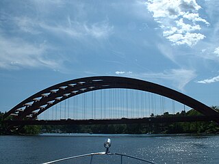
Dunsbach Ferry is a hamlet of the town of Colonie, in Albany County, New York, United States. The hamlet sits to the east of, and below, the Thaddeus Kosciusko Bridge, where Interstate 87 (I-87) crosses the Mohawk River. There are numerous private and public docks and landings between the Twin Bridges and the Colonie Town Park. Dunsbach Ferry was once an important river crossing and a stop on the Schenectady and Troy Railroad (T&S), later a branch of the New York Central Railroad. The ZIP code is 12047 (Cohoes).

The South Grand Island Bridge is a pair of twin two-lane truss arch bridges spanning the Niagara River between Tonawanda and Grand Island in New York, United States. Each bridge carries one direction of Interstate 190 (I-190) and New York State Route 324 (NY 324). Both crossings are operated by the New York State Thruway Authority as part of the Niagara Thruway. The southbound span was opened in 1935 and acquired by the State of New York in 1950. The northbound span was finished in 1962. A northbound-only toll is collected via Electronic Tolling.

New York State Route 146 (NY 146) is a state highway in the Capital District of New York in the United States. It extends for 43 miles (69 km) from Gallupville at NY 443 to near Mechanicville at U.S. Route 4 (US 4) and NY 32. NY 146 is a major thoroughfare in the city of Schenectady, just outside Albany. Most of the route follows an east–west alignment; however, the middle third of the route between Guilderland and Clifton Park runs in a more north–south manner in order to serve Schenectady. At one time, NY 146 had three spur routes; only one—NY 146A—still exists.

U.S. Route 9 (US 9) is a part of the United States Numbered Highway System that runs from Laurel, Delaware, to Champlain, New York. In New York, US 9 extends 324.72 miles (522.59 km) from the George Washington Bridge in Manhattan to an interchange with Interstate 87 (I-87) just south of the Canadian border in the town of Champlain. US 9 is the longest north–south U.S. Highway in New York. The portion of US 9 in New York accounts for more than half of the highway's total length.

New York State Route 167 (NY 167) is a north–south state highway in the Mohawk Valley region of New York in the United States. It extends for 26.17 miles (42.12 km) from an intersection with U.S. Route 20 (US 20) in the Otsego County village of Richfield Springs to a junction with NY 29 in the Herkimer County village of Dolgeville. Midway between the two endpoints, NY 167 passes through the city of Little Falls, where it meets NY 5 and indirectly connects to the New York State Thruway by way of NY 169. Most of NY 167 is a two-lane rural highway; however, in Little Falls, NY 167 ranges in width from two to four lanes as it serves commercial and industrial sections of the city.

Interstate 90 (I-90) is a part of the Interstate Highway System that runs from Seattle, Washington, to Boston, Massachusetts. In the US state of New York, I-90 extends 385.48 miles (620.37 km) from the Pennsylvania state line at Ripley to the Massachusetts state line at Canaan, and is the second-longest highway in the state after New York State Route 17 (NY 17). Although most of the route is part of the tolled New York State Thruway, two non-tolled sections exist along I-90. Within New York, I-90 has a complete set of auxiliary Interstates, which means that there are Interstates numbered I-190 through I-990 in the state, with no gaps in between. For most of its length in New York, I-90 runs parallel to the former Erie Canal route, NY 5, US Route 20 (US 20) and the CSX Transportation railroad mainline that traverses the state.

Interstate 687 (I-687) was a proposed auxiliary Interstate Highway in the Capital District region of New York in the United States. The highway would have connected I-90 in to I-87 and Albany International Airport in Colonie. I-687 faced opposition from those living in the path of the highway, and ultimately all that was built of the highway was its interchange with I-90 in Albany, which now connects to a surface road, Corporate Woods Boulevard. The project was canceled in 1973, and I-687 was removed from the Interstate Highway System four years later. A small portion of what would have been I-687 is now used as a connector between the Adirondack Northway and Albany International Airport; it, however, does not have a route designation and was completed as its own separate project in November 2019.
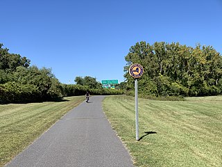
The Mohawk-Hudson Bike-Hike Trail (MHBHT) is a 97-mile (156 km) trail in New York's Mohawk Valley and Capital District regions. It is also the easternmost segment of the Erie Canalway Trail, as well as a portion of the Empire State Trail.
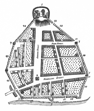
The streets of Albany, New York have had a long history going back almost 400 years. Many of the streets have changed names over the course of time, some have changed names many times. Some streets no longer exist, others have changed course. Some roads existed only on paper. The oldest streets were haphazardly laid out with no overall plan until Simeon De Witt's 1794 street grid plan. The plan had two grids, one west of Eagle Street and the old stockade, and another for the Pastures District south of the old stockade.

Tadeusz Kościuszko is one of the most honored persons in Polish history, in terms of places and events named in his honor.


 The bridge from land
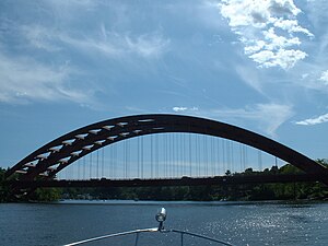 The view from the Mohawk River
 The view from below the bridge
 The bridge from I-87 Northbound


