Interstate 87 (I-87) is a 333.49-mile-long (536.70 km) north–south Interstate Highway located entirely within the US state of New York. I-87 is the main highway that connects New York City and Montreal. The highway begins at exit 47 off I-278 in the New York City borough of the Bronx, just north of the Robert F. Kennedy Bridge. From there, the route runs northward through the Hudson Valley, the Capital District, and the easternmost part of the North Country to the Canada–United States border in the town of Champlain. At its north end, I-87 continues into Quebec as Autoroute 15 (A-15). I-87 connects with several regionally important roads: I-95 in New York City, New York State Route 17 near Harriman, I-84 near Newburgh, and I-90 in Albany. The highway is not contiguous with I-87 in North Carolina.

Cohoes is an incorporated city located in the northeast corner of Albany County in the U.S. state of New York. It is called the "Spindle City" because of the importance of textile manufacturing to its growth in the 19th century. The city's factories processed cotton from the Deep South.

Menands is a village in Albany County, New York, United States. The population was 4,554 at the 2020 census. The village is named after Louis Menand. The village lies inside the town of Colonie and borders the northern city line of Albany.

Watervliet is a city in northeastern Albany County, New York, United States. The population was 10,375 as of the 2020 census. Watervliet is north of Albany, the capital of the state, and is bordered on the north, west, and south by the town of Colonie. The city is also known as "the Arsenal City".
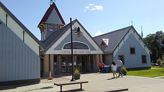
Clifton Park is a suburban town in Saratoga County, New York, United States. It is the largest municipality in the county, with a 2020 population of 38,029, according to the 2020 census. As such, it is the largest municipality in New York state east of Syracuse and north of Schenectady. The town's name is derived from an early land patent. The town is in the southern part of Saratoga County, approximately 12 miles (19 km) north of Albany, 7 miles (11 km) northeast of Schenectady, and 10 miles (16 km) south of Saratoga Springs.
Halfmoon is a town in Saratoga County, New York, United States. The population was 25,662 at the 2020 census. The town is apparently named for the shape of the lower elevation land north of the junction of the Hudson and Mohawk Rivers. It is also said to be named for Henry Hudson's ship, the Halve Maen.
Green Island is a coterminous town-village in Albany County, New York, United States, some 8 miles (13 km) north of Albany. Green Island is one of only five such town-village amalgamations in New York. The population was 2,934 at the 2020 census, and the ZIP code is 12183. While the town of Green Island was once an island, it was connected to the mainland on the west side of the Hudson River in the 1960s.

Colonie is a town in Albany County, New York, United States. It is the most-populous suburb of Albany, and is the third-largest town in area in Albany County, occupying approximately 11% of the county. Several hamlets exist within the town. As of the 2020 census, the town had a total population of 85,590.

New York State Route 2 (NY 2) is a state highway in the Capital District of New York in the United States. It extends for 30.89 miles (49.71 km) from an interchange with Interstate 87 (I-87) and NY 7 in the town of Colonie to the Massachusetts state line in Petersburgh, where it continues to Boston as Massachusetts Route 2. The route passes through the cities of Watervliet and Troy, where it connects to NY 32 and U.S. Route 4, respectively. In Grafton, located midway between Troy and Massachusetts, NY 2 serves Grafton Lakes State Park.

New York State Route 7 (NY 7) is a 180.30-mile-long (290.16 km) state highway in New York in the United States. The highway runs from the Pennsylvania state line south of Binghamton in Broome County, New York, to the Vermont state line east of Hoosick in Rensselaer County, where it continues as Vermont Route 9. Most of the road runs along the Susquehanna Valley, closely paralleling Interstate 88 (I-88) throughout that road's length. Portions of the highway route near the cities of Binghamton, Schenectady, and Troy date back to the early 19th century.
Latham is a hamlet and census-designated place in Albany County, New York, United States. It is located along U.S. Route 9 in the town of Colonie, a dense suburb north of Albany. In addition, Interstate 87 and U.S. Route 7 also run through the town itself. As of the 2020 census, the population was 13,680. Latham was a census-designated place in the 1970, 1980, and 1990 US Censuses, but ceased to be in the 2000 Census, then became a CDP again in 2020.

New York State Route 9R (NY 9R) is a north–south state highway in northeastern Albany County, New York, in the United States. The route is a 3.22-mile (5.18 km) eastern loop of U.S. Route 9 (US 9), connecting that route to the city of Cohoes 1.5 miles (2.4 km) to the east. It leaves US 9 in the hamlet of Latham and rejoins its parent in the hamlet of Boght Corners, both located in the town of Colonie. Most of NY 9R is a two-lane highway that passes through residential areas; however, the southwesternmost portion of the route is four lanes wide and serves a commercial district. The route was assigned c. 1939 and has remained largely unchanged since that time, save for a brief period during the 1970s where NY 9R was partially replaced by NY 470.
Boght Corners is a hamlet in the town of Colonie in northern Albany County, New York, United States, that straddles U.S. Route 9. The corners that give the hamlet its name are found at the intersection of Route 9 and Boght Road, near the Boght Community Fire District's station. The community is served by the North Colonie Central School District. Boght Hills Elementary School is located within the hamlet.
Crescent Station is a hamlet of the town of Colonie in Albany County, New York, United States that straddles US Route 9.
Verdoy, formerly known as Watervliet Center, is a hamlet of the town of Colonie in Albany County, New York, United States. Much of Verdoy is in the Airport Noise Overlay District due to its immediate proximity to Albany International Airport's main north/south runway, which was recently extended by 1,300 feet to the north, moving it even closer to Verdoy. The former Troy & Schenectady Branch of the New York Central Railroad runs along Verdoy's northern border with the Mohawk River; it is now part of the Mohawk Hudson Hike/Bike Trail.

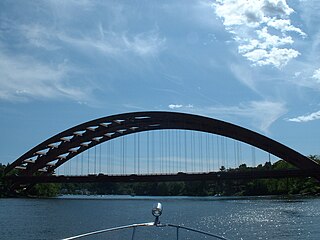
Crescent Bridge is a 1,229-foot (375 m) bridge over the Mohawk River and the Erie Canal. It is in Crescent, New York, a hamlet in the town of Halfmoon in southern Saratoga County on the northern side of the Mohawk River. The Crescent Bridge carries U.S Route 9 over the Mohawk River between the towns of Colonie in Albany County and Halfmoon.

New York State Route 787 (NY 787), known locally as Cohoes Boulevard, is a state highway in Albany County, New York, in the United States. It is a northern extension of Interstate 787 (I-787), continuing northward from the underpass at NY 7 near Green Island to downtown Cohoes at NY 32. For its entire length, NY 787 runs parallel to, and between, NY 32 and the Hudson River.

The Mohawk Towpath Scenic Byway is a National Scenic Byway in the Capital District region of New York in the United States. It extends from Schenectady to Waterford by way of a series of local, county, and state highways along the Mohawk River and the Erie Canal. The byway is intended to showcase the history of the waterway, from Native American times through the creation of the Erie Canal and the role the waterside communities played in the Industrial Revolution and the westward expansion of the United States. At its east end, the byway connects to the Lakes to Locks Passage, an All-American Road.

Vischer Ferry is a hamlet in the town of Clifton Park in Saratoga County, New York, United States, along the Mohawk River.

Niska Isle, despite its name, is not an island, but a peninsula in the town of Niskayuna, New York. Niska Isle is along the Mohawk River's south shore, with a back bay and swamp that surrounds it to the south.


