Westmere, New York

Last updated

Westmere, New York
Hamlet and CDP
Westmere, NY.jpg
Albany County New York incorporated and unincorporated areas Westmere highlighted.svg
Location in Albany County and the state of New York
Coordinates: 42°41′29″N73°52′34″W / 42.69139°N 73.87611°W / 42.69139; -73.87611
Country United States
State New York
Region Capital District
County Albany
Town Guilderland
Settled1920s
Area
[1]
  Total
3.18 sq mi (8.23 km2)
  Land3.17 sq mi (8.21 km2)
  Water0.01 sq mi (0.03 km2)
Elevation
292 ft (89 m)
Population
 (2020)
  Total
7,560
  Density2,385.61/sq mi (921.03/km2)
Time zone UTC-5 (EST)
  Summer (DST) UTC-4 (EDT)
ZIP Codes
12203 (Albany)
12084 (Guilderland)
12159 (Slingerlands)
Area code 518
FIPS code 36-80423 [2]
GNIS feature ID0970925 [3]

Westmere is a hamlet in the town of Guilderland, Albany County, New York, United States. Since the 1970 Census, a census-designated place (CDP) has been established with the name of Westmere for tabulating the population of what the census has defined as the boundaries for Westmere. The population was 7,284 at the 2010 census. [4] It is a suburb of the neighboring city of Albany. U.S. Route 20 (Western Avenue) bisects the community and is the major thoroughfare and main street. Along Western Avenue are numerous strip malls, shopping plazas, and commercial buildings, with residential use on the side streets to the north and south. Crossgates Mall, the Capital District's largest shopping mall, is in Westmere's northeastern corner.

Contents

History

Westmere as a settled place is of recent origin, though being along the Great Western Turnpike, built in 1799, it was always a place migrants passed through on their way from Albany and New England to the western frontier. A toll gate existed on the turnpike roughly where Highland Estates is located. Even before the turnpike was built, 300 wagons (and sleighs in the winter) passed through in 1796 what would later become Westmere. After World War I, development began to encroach on the rural wooded area with mostly bungalows and cottages. This would accelerate in the post-war era after World War II, and in the 1940s is when the name Westmere would be given to this area. Westmere was the fastest growing section of the town of Guilderland in this period. [5]

Geography

As a hamlet, the borders of Westmere are only loosely defined. As a census-designated place (CDP) however, the borders (as of the 2010 census) are exactly defined as the city of Albany to the north, then following New York Route 155 (State Farm Road/New Karner Road) as the western border. The southern border follows Doctor Shaw Road from its intersection with NY 155, then turns northeast onto Veeder Road until its termination with Johnston Road. At Johnston Road, the border turns north and follows it until it takes a right onto Church Road and follows it to the intersection with U.S. Route 20 (Western Avenue). The border then takes a right on Western Avenue to the Governor Thomas E. Dewey Thruway (Interstate 87) and goes north to the Albany city line. These borders can change from census to census. According to the United States Census Bureau in 2000, the CDP has a total area of 3.2 square miles (8.3 km2), all land.

Location

Demographics

Westmere CDP Historical Populations
YearPop.±%
1970 6,364    
1980 6,881+8.1%
1990 6,750−1.9%
2000 7,188+6.5%
2010 7,284+1.3%
2020 7,560+3.8%
Source: U.S. Decennial Census [6]

As of the census [2] of 2000, there were 7,188 people, 3,162 households, and 1,903 families residing in the CDP. The population density was 2,259.8 inhabitants per square mile (872.5/km2). There were 3,287 housing units at an average density of 1,033.4 per square mile (399.0/km2). The racial makeup of the CDP was 88.75% White, 3.62% African American, 0.04% Native American, 6.25% Asian, 0.03% Pacific Islander, 0.43% from other races, and 0.89% from two or more races. Hispanic or Latino of any race were 2.00% of the population.

There were 3,162 households, out of which 26.6% had children under the age of 18 living with them, 48.1% were married couples living together, 9.2% had a female householder with no husband present, and 39.8% were non-families. 32.4% of all households were made up of individuals, and 10.3% had someone living alone who was 65 years of age or older. The average household size was 2.25 and the average family size was 2.90.

In the CDP, the population was spread out, with 21.1% under the age of 18, 6.6% from 18 to 24, 31.7% from 25 to 44, 24.9% from 45 to 64, and 15.7% who were 65 years of age or older. The median age was 40 years. For every 100 females, there were 90.6 males. For every 100 females age 18 and over, there were 87.8 males.

The median income for a household in the CDP was $55,000, and the median income for a family was $61,827. Males had a median income of $45,769 versus $32,937 for females. The per capita income for the CDP was $28,790. About 3.0% of families and 4.1% of the population were below the poverty line, including 2.5% of those under age 18 and 4.4% of those age 65 or over.

Fire Protection

The Westmere Fire Department was formally incorporated on December 31, 1935 for the protection of the residents of the community. In 1937, the Westmere Fire District was recognized by the New York State Comptroller. Today, the Westmere Fire Department continues to be 100% volunteer, with over 50 active firefighters volunteering at the busiest fire department in the Town of Guilderland. The department operates with three fire engines, a tower-ladder, one heavy-rescue truck, a multi-purpose pickup truck, and two command vehicles.

Related Research Articles

<span class="mw-page-title-main">Blue Hills, Connecticut</span> Place in Connecticut, United States

Blue Hills is a community in Hartford County, Connecticut, United States, encompassing the northwestern corner of the city of Hartford and the southeastern corner of the town of Bloomfield. The Bloomfield portion is listed by the U.S. Census Bureau as a census-designated place (CDP), with a population of 2,762 at the 2020 census.

<span class="mw-page-title-main">Okahumpka, Florida</span> Census-designated place in Florida

Okahumpka is an unincorporated community and census-designated place (CDP) in Lake County, Florida, United States. The population was 267 at the 2010 census. It is part of the Orlando–Kissimmee Metropolitan Statistical Area.

<span class="mw-page-title-main">Palmona Park, Florida</span> Census-designated place in Florida, United States

Palmona Park is a census-designated place (CDP) in Lee County, Florida, United States. The population was 1,240 at the 2020 census, up from 1,146 at the 2010 census. It is part of the Cape Coral-Fort Myers, Florida Metropolitan Statistical Area.

<span class="mw-page-title-main">Kendale Lakes, Florida</span> Census-designated place in Florida

Kendale Lakes is a census-designated place (CDP) and a suburb of Miami in Miami-Dade County, Florida, United States. It is located in the Miami metropolitan area of South Florida. The population was 55,646 at the 2020 census.

<span class="mw-page-title-main">Palmetto Estates, Florida</span> Census-designated place in Florida

Palmetto Estates is an unincorporated area and census-designated place (CDP) in Miami-Dade County, Florida, United States. It is part of the Miami metropolitan area of South Florida. The population was 13,498 at the 2020 census.

<span class="mw-page-title-main">Parkville, Maryland</span> Census-designated place in Maryland, United States

Parkville is an unincorporated community and census-designated place in Baltimore County, Maryland, United States. As of the 2010 census, the population was 30,734.

<span class="mw-page-title-main">Dennis Port, Massachusetts</span> Census-designated place in Massachusetts, United States

Dennis Port is a census-designated place (CDP) in the town of Dennis in Barnstable County, Cape Cod, Massachusetts, United States. At the 2010 census, its population was 3,162.

<span class="mw-page-title-main">Littleton Common, Massachusetts</span> Census-designated place in Massachusetts, United States

Littleton Common is a census-designated place (CDP) in the town of Littleton in Middlesex County, Massachusetts, United States. The population was 3,065 at the 2020 census, up from 2,789 in 2010.

<span class="mw-page-title-main">East Merrimack, New Hampshire</span> Census-designated place in New Hampshire, United States

East Merrimack is a census-designated place (CDP) in the town of Merrimack, Hillsborough County, New Hampshire, United States. There is no village center named "East Merrimack"; rather, the CDP refers to the region of the town of Merrimack lying east of the F. E. Everett Turnpike, overlapping portions of the villages of Reeds Ferry, Thornton's Ferry, and the center of Merrimack. The population was 5,176 at the 2020 census, up from 4,197 at the 2010 census.

Delmar is a hamlet in the Town of Bethlehem, in Albany County, New York, United States. It is a suburb of the neighboring city of Albany. The community is bisected by NY Route 443, a major thoroughfare, main street, and route to Albany.

<span class="mw-page-title-main">Guilderland, New York</span> Town in New York, United States

Guilderland is a town in Albany County, New York, United States. In the 2020 census, the town had a population of 36,848. The town is named for the Gelderland province in the Netherlands. The town of Guilderland is on the central-northwest border of the county. It is just west of Albany, the capital of the U.S. state of New York.

<span class="mw-page-title-main">North Merrick, New York</span> Hamlet and Census-designated place in New York, United States

North Merrick is a hamlet and census-designated place in the Town of Hempstead, in Nassau County, near the South Shore of Long Island, in New York, United States. The population was 12,238 at the time of the 2020 census.

<span class="mw-page-title-main">Sound Beach, New York</span> Hamlet and census-designated place in New York, United States

Sound Beach, established in 1929, is a hamlet and census-designated place (CDP) in the north part of the Town of Brookhaven in Suffolk County, New York, United States. The population of the CDP was 7,612 at the 2010 census.

<span class="mw-page-title-main">Valhalla, New York</span> Hamlet in New York, United States

Valhalla is a hamlet and census-designated place (CDP) within the town of Mount Pleasant, in Westchester County, New York, United States, in the New York City metropolitan area. Its population was 3,162 at the 2010 U.S. Census. The name was inspired by a fan of the composer Richard Wagner, and the hamlet is known both as the home of the primary hospital campus of Westchester Medical Center and New York Medical College and as the burial place of numerous noted people. Valhalla is named after the hall of the slain in Norse mythology.

<span class="mw-page-title-main">Folsom, Pennsylvania</span> Census-designated place in Pennsylvania, United States

Folsom is a census-designated place (CDP) in Delaware County, Pennsylvania, United States. It is part of Ridley Township. The population was 8,323 at the 2010 census.

<span class="mw-page-title-main">Lincolnia, Virginia</span> Census-designated place in Virginia, United States

Lincolnia is a census-designated place (CDP) in Fairfax County, Virginia, United States. The population was 22,828 at the 2010 census, an increase of over 44% from 2000.

<span class="mw-page-title-main">Canton Valley, Connecticut</span> Census-designated place in Connecticut, United States

Canton Valley is a village and census-designated place (CDP) in the town of Canton in Hartford County, Connecticut, United States. The population was 1,580 at the 2010 census. As of the 2017 census the population was 1,489.

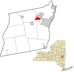
McKownville is a hamlet in the town of Guilderland, Albany County, New York, United States. It lies along the eastern border of the town with the city of Albany. McKownville is a heavily developed suburb of Albany and is home to many strip malls, shopping centers, and a portion of the University at Albany, SUNY and is bisected by U.S. Route 20. McKownville is named for John McKown and family, early settlers from the late 18th century.

<span class="mw-page-title-main">Hudson (CDP), Massachusetts</span> Census-designated place in Massachusetts, United States

Hudson is a census-designated place (CDP) comprising the densely developed central part of the town of Hudson in Middlesex County, Massachusetts, United States. The population of the CDP was 15,749 at the 2020 census, out of 20,092 in the entire town.

<span class="mw-page-title-main">Jefferson Valley, New York</span> Census-designated place in New York, United States

Jefferson Valley-Yorktown, commonly known as Jefferson Valley, is a census-designated place (CDP) located in the town of Yorktown in Westchester County, New York, United States. The population was 14,142 at the 2010 census. It is a hot spot for local shoppers, due to its Jefferson Valley Mall.

References

  1. "ArcGIS REST Services Directory". United States Census Bureau. Retrieved September 20, 2022.
  2. 1 2 "U.S. Census website". United States Census Bureau . Retrieved January 31, 2008.
  3. "US Board on Geographic Names". United States Geological Survey. October 25, 2007. Retrieved January 31, 2008.
  4. "Race, Hispanic or Latino, Age, and Housing Occupancy: 2010 Census Redistricting Data (Public Law 94-171) Summary File (QT-PL), Westmere CDP, New York". United States Census Bureau . Retrieved August 31, 2011.
  5. Alice Begley and Mary Ellen Johnson (1999). Guilderland, New York. Arcadia Publishing. pp. 22–28. ISBN   0-7385-0112-3 . Retrieved February 14, 2010.
  6. "Census of Population and Housing". Census.gov. Retrieved June 4, 2016.