
Albany County is a county in the state of New York, United States. Its northern border is formed by the Mohawk River, at its confluence with the Hudson River, which is to the east. As of the 2020 United States Census, the population was 314,848. The county seat and largest city is Albany, which is also the state capital of New York. As originally established by the English government in the colonial era, Albany County had an indefinite amount of land, but has had an area of 530 square miles (1,400 km2) since March 3, 1888. The county is named for the Duke of York and of Albany, who became James II of England. The county is part of the Capital District region of the state.

Watervliet is a city in northeastern Albany County, New York, United States. The population was 10,375 as of the 2020 census. Watervliet is north of Albany, the capital of the state, and is bordered on the north, west, and south by the town of Colonie. The city is also known as "the Arsenal City".
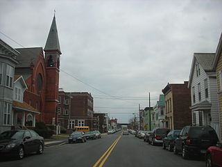
Green Island is a coterminous town-village in Albany County, New York, United States, some 8 miles (13 km) north of Albany. Green Island is one of only five such town-village amalgamations in New York. The population was 2,934 at the 2020 census, and the ZIP code is 12183. While the town of Green Island was once an island, it was connected to the mainland on the west side of the Hudson River in the 1960s.

Colonie is a town in Albany County, New York, United States. It is the most-populous suburb of Albany, and is the third-largest town in area in Albany County, occupying approximately 11% of the county. Several hamlets exist within the town. As of the 2020 census, the town had a total population of 85,590.

Niskayuna is a town in Schenectady County, New York, United States. The population was 23,278 at the 2020 census. The town is located in the southeast part of the county, east of the city of Schenectady, and is the easternmost town in the county.

Loudonville is a hamlet in the town of Colonie, in Albany County, New York, United States. Loudonville was a census-designated place (CDP) in the 1970, 1980, and 1990 US Census. It ceased to be a CDP in the 2000 Census, but regained its status in 2020.
Latham is a hamlet and census-designated place in Albany County, New York, United States. It is located along U.S. Route 9 in the town of Colonie, a dense suburb north of Albany. In addition, Interstate 87 and U.S. Route 7 also run through the town itself. As of the 2020 census, the population was 13,680. Latham was a census-designated place in the 1970, 1980, and 1990 US Censuses, but ceased to be in the 2000 Census, then became a CDP again in 2020.
Boght Corners is a hamlet in the town of Colonie in northern Albany County, New York, United States, that straddles U.S. Route 9. The corners that give the hamlet its name are found at the intersection of Route 9 and Boght Road, near the Boght Community Fire District's station. The community is served by the North Colonie Central School District. Boght Hills Elementary School is located within the hamlet.
New York State Route 155 (NY 155) is a 16.85-mile-long (27.12 km) state highway located entirely within Albany County in the Capital District of New York. The western terminus of the route is at NY 85A in Voorheesville. The eastern terminus is at NY 32 in Watervliet. NY 155 mainly serves as a connection to the Albany International Airport from the major roads it connects to.
Dunsbach Ferry is a hamlet of the town of Colonie, in Albany County, New York, United States. The hamlet sits to the east of, and below, the Thaddeus Kosciusko Bridge, where Interstate 87 (I-87) crosses the Mohawk River. There are numerous private and public docks and landings between the Twin Bridges and the Colonie Town Park. Dunsbach Ferry was once an important river crossing and a stop on the Schenectady and Troy Railroad (T&S), later a branch of the New York Central Railroad. The ZIP code is 12047 (Cohoes).
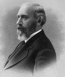
Robert Hewson Pruyn was an American lawyer, militia general, diplomat, and politician from Albany, New York. He was most notable for his service as Speaker of the New York State Assembly, Adjutant General of New York, and United States Minister Resident to Japan.
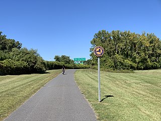
The Mohawk-Hudson Bike-Hike Trail (MHBHT) is a 97-mile (156 km) trail in New York's Mohawk Valley and Capital District regions. It is also the easternmost segment of the Erie Canalway Trail, as well as a portion of the Empire State Trail.
Newtonville is a hamlet in the town of Colonie in Albany County, New York, United States. Located along U.S. Route 9, the hamlet is just south of Latham and north of Loudonville. Colonie Town Hall is located in the hamlet of Newtonville.
Watervliet was a town that at its height encompassed most of present-day Albany County and most of the current town of Niskayuna in neighboring Schenectady County, in the state of New York, United States. Just prior to its dissolution, the town encompassed the current towns of Colonie and Green Island and the city of Watervliet.
Mohawk Mall was an enclosed shopping mall in the town of Niskayuna, New York, on a 50-acre (200,000 m2) parcel located at the corner of State Street and Balltown Road. It was managed by Genesee Management. It had three courts with groups of fountains and seating areas. The mall was first opened in 1970 and mostly demolished in 2000, with its last remaining section demolished in 2002. The property has been redeveloped into Mohawk Commons, a lifestyle center.
Lisha Kill is a hamlet in the town of Colonie, Albany County, New York, United States. Lisha Kill lies on New York Route 5 in the western section of the town. The hamlet received its name from the creek of the same name, Lisha Kill, kill being Dutch for creek or stream. The stream is also referred to as Lisha's Kill and received its name from a local legend about a Native American woman who is buried along its banks.

Niska Isle, despite its name, is not an island, but a peninsula in the town of Niskayuna, New York. Niska Isle is along the Mohawk River's south shore, with a back bay and swamp that surrounds it to the south.
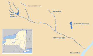
Patroon Creek is a stream in Albany County, New York, United States and is a tributary of the Hudson River which flows south to New York Harbor and the Atlantic Ocean. The creek's source is Rensselaer Lake in the western section of the city of Albany. Patroon Creek received its name from the patroon of Rensselaerswyck.

North Albany is a neighborhood in the city of Albany, New York. North Albany was settled in the mid-17th century by the Patroon of Rensselaerswyck and his tenants and later became a hamlet in the town of Watervliet. Due to the Erie Canal being constructed in 1825, North Albany saw immense growth, with the Albany Lumber District and an influx of Irish immigrants lending the area the name of Limerick. Home to many historic warehouses and row houses, North Albany continues to be an important industrial neighborhood. Recent efforts have begun to gentrify the neighborhood by adapting heavy industry/warehouse use to artistic and entertainment venues, such as a German beer garden, an amusement park, live music venues, and arts and crafts marketplaces.

The Sprouts of the Mohawk River are the multiple channels of the Mohawk River as it flows into the Hudson River creating a delta in the US state of New York. Most of the sprouts lie within Albany County, with the northern ones in Saratoga County, and the sprouts enter the Hudson at the boundary with Rensselaer County. The islands formed by the sprouts are, from north to south–Peebles Island, Polrump Island, Bock Island, Goat Island, Second Island, Van Schaick Island, Simmons Island. and formerly Green Island. The sprout separating Green Island from the rest of Albany County was filled in with the creation of Interstate 787 and NY Route 787.


